Grieta Negra
| Rating: | |||||||||||||||||||||||||||||||
|---|---|---|---|---|---|---|---|---|---|---|---|---|---|---|---|---|---|---|---|---|---|---|---|---|---|---|---|---|---|---|---|
|
| |||||||||||||||||||||||||||||||
| | Difficulty:3B I (v3a2 I) Raps:1-5, max ↨39ft
Red Tape:No permit required Shuttle:None Vehicle:Passenger Rock type:Volcanic, limestone | ||||||||||||||||||||||||||||||
| Location: | |||||||||||||||||||||||||||||||
| Condition Reports: | 30 Dec 2021
"Water gently flowing. Temperature is COLD - only a few degrees above freezing. At least one bolt has been removed. Lots of insects inside, although th |
||||||||||||||||||||||||||||||
| Best season: | Any
|
||||||||||||||||||||||||||||||
| Regions: | |||||||||||||||||||||||||||||||

Introduction
Grieta Negra is a short, shallow stream that goes under stable rockfall of huge boulders. Most of the route is dim or dark, and a headlight is essential.
Rappels can be generally be downclimbed. There are several tight squeezes too, all of which are avoidable. Any time of year, there's likely a trickle of water. Wading should generally be less than thigh-deep. In decent flow, or very cold days, a wetsuit is advised.
It's debated if this route counts as a canyoneering route. Pretty much all obstacles can be bypassed, as there are easy exits from the 'canyon' every few meters, and a hiking trail parallels the canyon, only 5 meters away on the eastern side. Escapes are nearly continuous.
Still, if in the area it makes for some fun. Much better is nearby Paraíso Escondido Canyon. Doing Grieta Negra first, and then heading directly to Paraíso Escondido, is a fun day.
Approach
Desde el estacionamiento seguir la única vereda descendente, paralela al arroyo, hasta encontrar los primeros grandes bloques que obstruyen el cauce, y localizar el hueco apropiado para bajar buscando la plaqueta.
There are several parking options. The closest is given on the map, and shown below.

From the parking area, cross the road, head 30 meters down a small path. It intersects with a larger trail. Turn right here. It quickly opens into a grassy area. Cross the grassy area, which brings you along a stream immediately, which will be on your left. Follow the trail down along the stream fro 5-10 minutes. There will be a variety of entrances to choose from on your left, all of which look like a void, but none of which drop more than a few meters. All 'entrances' can be easily downclimbed.


Descent
El barranco consiste en su mayor parte en una estrecha garganta cubierta y obstruida por enormes bloques colapsados, con muchos puntos en que la oscuridad es total y se requiere linterna. Hay varios rapeles pequeños (el mayor de 12 m), destrepes y pasos angostos entre los bloques, incluyendo un casi sifón.
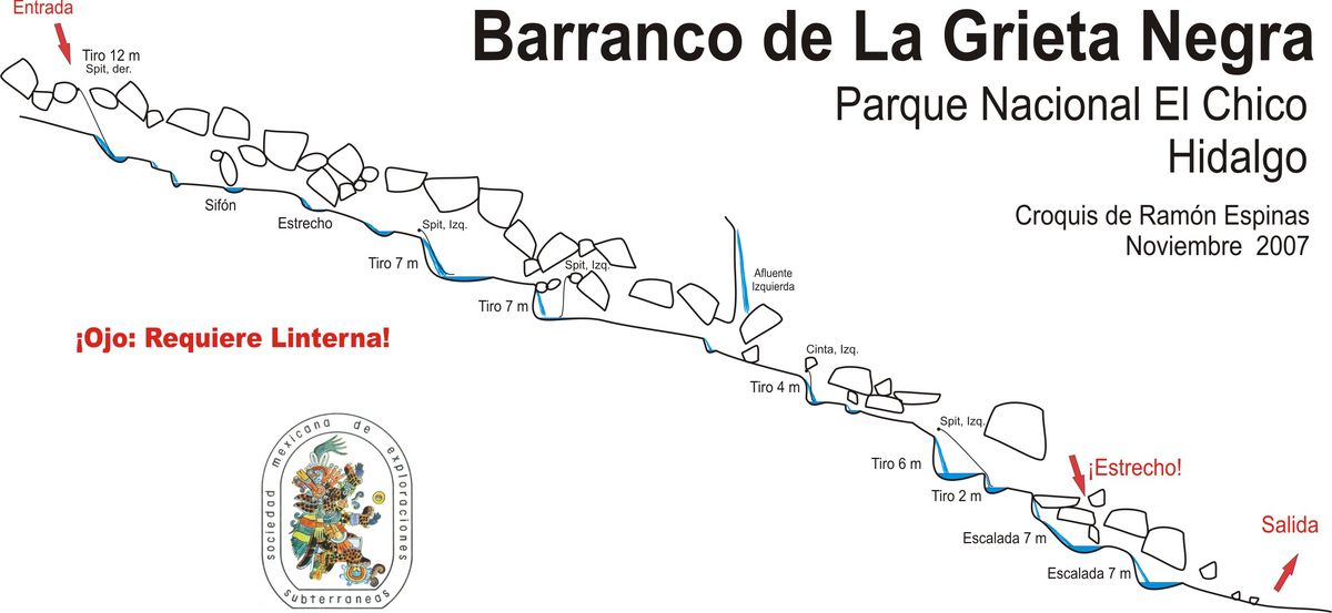
Pick an entrance and slide into the boulder chaos! Just follow the tiny stream inside. There are a number of small downclimbs. To avoid the cold water, you may be stemming at times. There is at least one tight squeeze where most people will want to remove their helmet. All obstacles can be bypassed by exiting the canyon on canyon-right and then re-entering below. Escapes are numerous.
Bring at least a handline. Some canyoneers may want to rappel. As of 2021, at least one set of bolts has been removed, and another anchor is a bolt/hanger with no quicklink.
Headlight is mandatory. Whoever did this route without a headlamp must have nocturnal vision.


Exit
Al salir del barranco, buscar la vereda ascendente por la derecha, que regresa al estacionamiento.
Exit the canyon by climbing up on canyon right. The stream trail is immediately right there. Follow the trail back up to your car.
Red tape
Beta sites
 Barranquismo.net : Grieta Negra
- Cañonismo.com : La Grieta Negra
Trip reports and media
Background
A pesar de su cercanía a los barrancos de Paraiso Escondido y de Las Brujas, explorados por escaladores locales desde 1948, no se conoce de ninguna exploración hasta noviembre de 2007, en que fue recorrido por miembros de la Sociedad Mexicana de Exploraciones Subterráneas (Ramón Espinasa, Sergio Nuño y Jesús García)