Heaps Canyon
| Rating: | ||||
|---|---|---|---|---|
|
| ||||
| | Difficulty:4B V R (v5a2 V) Raps:25, max ↨290ft
Red Tape:Permit required Shuttle:None Vehicle:Passenger | |||
| Location: | ||||
| Condition Reports: | 27 Jun 2026
"Heaps is in Hard (fun) Mode!. Potholes lower than Ive ever seen them! Get it while it’s good! Hook/aider helpful for a few keepers.. 4/3 wetsu |
|||
| Best season: | ||||
| Regions: | ||||

Introduction
This is one of the hardest canyons in Zion. Very long and cold but relatively easy if potholes are full, it can become extremely difficult in adverse conditions.
Tom Jones' preface to Heaps is a must-read for those unfamiliar with its difficulty.
Approach
Approach from Lava Point for a longer but less strenuous hike (requires a long shuttle) or from the Grotto for a shorter but steeper hike (no shuttle).
Both routes intersect at the same point where you now need to find a way down to Phantom Valley below.
Option A - The Knife Edge
This is the classic route that most take, as described by Tom Jones:
Work your way down the ridge, carefully following small social trails to avoid the worst of the brush. Progress on the ridge is soon blocked by a short cliff band. A small tree with slings above a dirt and gravel slope provides a possible rappel anchor, but a cleaner rappel can be found by stepping 10ft West, over a rock ridge and slinging a block (may require a long sling). Rappel 65' to the ground. Continue down the ridge, downclimbing on the left side when needed. Delicately climb an exposed, crumbling knife-edge ridge to a large tree on the right. Rap from a tree 210' to the high point of the ground.
Be aware, there are incorrectly placed anchors along this ridge. Some of which will put you in a challenging location to get all the way down to the valley floor.
From the bottom of the rappel, work your way down to the slickrock, then down the slickrock ridge to the watercourse of Phantom Valley.
Option B - The Bowl
Directly East of the Knife Edge lies a huge bowl shaped amphitheater providing an interesting alternative for getting down to Phantom Valley.
Follow KML "Bowl Approach" over to a large horizontal sandstone beam that lies over a gap at the edge of a cliff. From this beam, using ghosting methods, rappel 200' down to a large bench below. This rappel turns free-hanging halfway down.
Directly in front of where you land is a huge tree at the cliff edge. Walk around the DCR side of the tree and rig your rope with a toggle off the front-most limb. Rappel 300' down a clean sloping wall to the floor below. (Avoid the brushy cutaways in the wall on DCR as you rappel, they will swallow you if you get off course. )
Follow slick rock down a short ways to find a 2 bolt unlinked anchor slightly off center DCL. Rappel 220’ to canyon floor. (A 200’ rope will work here with a short downclimb)
Follow slot canyon down and out. At the end you will reach a final 30' rappel off a single bolt DCR that spits you out of the slot into Phantom Valley.
Phantom Valley
Hike down Phantom Valley sidestepping a few small difficulties about 45 minutes to a niche where the canyon dramatically narrows up, marked by some big trees. This is the suit-up spot.
Descent
Phantom Valley Narrows
After a brief downclimb, short walk and refreshing swim, the real fun begins with a rappel through a series of beautiful pools. The first rappel is the longest in the canyon before the end, at 65 feet. After a few more rappels and swims, a few pothole problems and a swim under an arch, the canyon opens up briefly (the short, gravelly corridor) before closing in for another rappel-pool-pothole section. When full, this section is easy and fun. When the water is a little lower, as many as eight challenging pothole escapes may be required.
The canyon then opens up and works its way through a section with canyons coming in on both sides. Where a major canyon (Gunsight) comes in from the north is called The Crossroads. When people bivy, they often bivy here. There is sometimes nice flat sand.
Escape Route If necessary, from the bivy site it is possible to escape to the south through Isaac Canyon. Hike up the canyon to the south with a few spots of scrambling to a pass, then down the other side with several rappels. A final 300 foot rappel ends in the Court of the Patriarchs. There is no water on this route.
Crossroads The Crossroads continues. From the bivy spot, traverse right past a long pothole and rappel off a tree (or swim the pothole). A few minutes of hiking takes you to the Long Sandy Corridor. At the end of the Corridor, the canyon turns sharply left and plunges into darkness.
Terminal Narrows
The next section of narrows is long and intense. It is at least half again longer than the Phantom Valley section, with an interesting variety of problems. It also tends to be colder, and at times has really long swims. Near the end, there are potential bivy spots high and left above the streamcourse during most conditions. Strenuous climbing, pack tosses, ingenuity and, as a last resort, drilling and hooking may be required to pass the numerous difficulties. Many hours later, the intense narrows relent and the huge, smooth face of Lady Mountain can be seen on the right. A flat sandy corridor leads to a flat rock and a plunging slot on the left. The flat rock is often used to remove dry and wet suits and prepare for the final rappel sequence.
Bird Perch Final Rappel Sequence
At the end of the final hallway, on the RIGHT SIDE, climb 30 feet (5.4? chimney) to the top of a lump. Walk over the lump and downclimb the crack 30 feet to a ledge with a small tree.
R1 - Rappel 60' down the crack to an exposed sloped ledge at a large tree. Be careful not to release any blocks on the way down and on the ledge, as there may be hikers below visiting the Upper Emerald Pool.
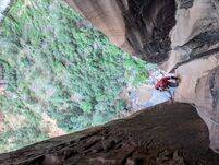
R2 - From the large tree, rappel 145' down a vertical wall to a small ledge set back in the corner, the “Bird Perch”. There is some loose rock on this rap too. Do NOT underestimate this rappel: it is vertical to overhanging the entire length.
R3 - From the Bird Perch, rappel 280' freehanging to the talus below
Alternate Watercourse Direct Finish
Instead of the Bird Perch finish you can stay in the watercourse and do a three rappel sequence. These rappels are inside a 10 foot side slot for the most part. This route cannot be used when there is any water flow. Leaving webbing on any of the anchors is highly undesirable. Don't Do It.
R1-60ft, plenty of room at the bottom. Please ghost this rappel off any of several possible anchors. Leaving slings here might entice clueless parties to go this way.
R2-80ft, off two unlinked bolts. Do not rig webbing on these bolts; keeping a low profile helps prevent the clueless from going this way. R2 lands on a sloping ledge and can accommodate perhaps four people. Bolts are on the left hand wall (LDC).
R3-360ft, from two unlinked bolts starts on a vertical wall and becomes free hanging about 100 feet down.
Exit
The last rappel ends at Upper Emerald Pools. Hike down the popular trail to the Lodge.
Red tape
Permits
Permits are required with a group-size limit of 6 people.
The permit system is complicated and is no longer administered by the park service. However, it is advisable to start at the park's webpage for canyoneering permit information when looking for permits and details about how they are obtained and other regulations and timeframes. Zion NP Canyoneering Permits: https://www.nps.gov/zion/planyourvisit/canyoneeringpermits.htm
Vehicle (Yellow) Passes
If you are starting Heaps or Imlay from the main Zion Canyon floor and hiking up the West Rim Trail, the park WILL issue you a vehicle pass. This is because these canyons require an early start—well before the in-canyon shuttles begin operating for the day—and you’ll need a permit to drive up Zion Canyon and leave a vehicle at the trailhead.
If you are starting from Lava Point, however, the park WILL NOT issue a vehicle pass. Even though you’ll be relying on the in-canyon shuttle to return at the end of the day, the Park’s reasoning is that since you can reach Lava Point on your own schedule, you should be able to start early enough to complete the canyon and catch the last shuttle without needing to leave a vehicle in Zion Canyon.
It's possible that some rangers better understand the implications of the policy and may be willing to issue vehicle passes for those doing the top-down route. Rangers do have some discretion, but the above information is based on the official policy and email correspondence with the Zion Wilderness Desk.
Beta sites
 BluuGnome.com : Heaps Canyon
- CanyoneeringUSA.com : via Phantom; exit watercourse
- Climb-Utah.com : Heaps Canyon
- CanyonChronicles.com : Heaps Canyon
 Zion Canyoneering Book by Tom Jones : Heaps via Phantom
- ZionCanyoneering.com : Heaps Canyon
- SummitPost.org : Heaps Canyon
Trip reports and media
- Dennis Turville on Canyon Tales : Heaps Canyon (via Gunsight), September 23-25, 1981
- Dennis Turville on Canyon Tales : Desscent info for Heaps Canyon (via Gunsight), September 23-25, 1981
- Bo Beck on Canyon Tales : A First Trip in Heaps, June 1993 (via Gunsight)
- Ram on Canyon Tales : Escape from Heaps
- Dave Black on Canyon Tales : A Shitty Trip in heaps
- Randi Poer on Canyon Tales : Heaps ... Revisited!
- Luca Chiarabini - Heaps
- Candition.com : Heaps
June 9, 2016: Group of 5 including two pro guides. 13 hours car-to-car from the Grotto. Water levels not full but not super low. Some pothole escape techniques were needed on a couple. Lots of fun stuff inc. pack tosses, pack anchors, floating anchor, guided rappel, etc. The group we passed did not have these skills and likely took over 15 hours and were expending a lot of energy.
September 3, 2016: http://amazingslots.blogspot.com/2016/09/heaps-canyon.html