High Creek
| Rating: | |||||||||||||||||||||||||||||||
|---|---|---|---|---|---|---|---|---|---|---|---|---|---|---|---|---|---|---|---|---|---|---|---|---|---|---|---|---|---|---|---|
| | Difficulty:3A III (v3a1 III) Raps:4-7, max ↨120ft
Red Tape:Permit required Shuttle:None Vehicle:Passenger | ||||||||||||||||||||||||||||||
| Location: | |||||||||||||||||||||||||||||||
| Condition Reports: | 6 Jun 2021
"No flow in most of High Creek and a tiny trickle near the bottom. Added webbing at R1, and put rope around R2 tree directly. What I assumed to be R3 a |
||||||||||||||||||||||||||||||
| Best season: | anytime
|
||||||||||||||||||||||||||||||
| Regions: | |||||||||||||||||||||||||||||||
Introduction[edit]
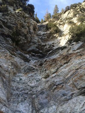
I lost all my notes for this canyon so note that this beta is off my hazy memory. The canyon itself doesn't have much to offer, we did 4 rappels. There is a lot of down climbing and the canyon resembles a large gully. A lot of boulders and loose rocks to negotiate. Some large rock columns on either side of the canyon loose ready to come down.
Approach[edit]
You park at the same parking lot for Big Falls (Southern California) at the Vivian Creek trail head. This trail requires a permit that can be obtained here. Your parked vehicle will also require an Adventure Pass or equivalent. You take the Vivian Creek trail past the half way camp site. Shortly after, the trail makes a switchback west, before doing so you leave the trail and continue heading east. Pick the path of least resistance find a suitable drop in into High Creek. Every option looked precarious as the soil is not stable.
Descent[edit]
Once at the bottom, you will come to the beginning of the technical section almost immediately. The first rappel was 80' if memory serves me right. I don't recall the rest. One thing that comes to mind was a rappel that we anchored off a dying bush LDC. As I was building the anchor, I found very old black webbing, so this route has been done but not documented. There will be a substantial amount of down climbing throughout.
June 2021 description
R1: 50' - boulder
A long low-angle downclimb follows that could be rappelled.
R2: 50' - tree DCL
R3: 120' - tree DCL
R4: 40' - boulder
Exit[edit]
High Creek meets with Mill Creek. Follow Mill Creek downstream until you reach your vehicle. Keep an eye out for the location you crossed Mill Creek on your way up at the beginning, so that the last stretch is on the same road you took up.
Red tape[edit]
Permit is required for the Vivian Creek trail and an Adventure Pass for your vehicle.
Wilderness Permit Online Reservation:
https://sgwa.org/wilderness-permits/
Beta sites[edit]
Trip reports and media[edit]
- - February 16, 2014 by Christian Lupercio
