Hinkle Tinkle Creek
| Rating: | |||||||||||||||||||||||||||||||
|---|---|---|---|---|---|---|---|---|---|---|---|---|---|---|---|---|---|---|---|---|---|---|---|---|---|---|---|---|---|---|---|
| | Raps:6-9, max ↨90ft
Red Tape:No permit required Shuttle:Optional 2.2mi Vehicle:High Clearance | ||||||||||||||||||||||||||||||
| Start: | |||||||||||||||||||||||||||||||
| Parking: | |||||||||||||||||||||||||||||||
| Shuttle: | |||||||||||||||||||||||||||||||
| Condition Reports: | 3 Jun 2023
"It looks like locals may visit some of the trail-side falls occasionally, but, otherwise, no signs of other visitors were encountered, so this may be |
||||||||||||||||||||||||||||||
| Best season: | Apr-May
|
||||||||||||||||||||||||||||||
| Regions: | |||||||||||||||||||||||||||||||
Introduction[edit]
Hinkle Tinkle is merry, burbling, friendly creek likely named back in the 1950's when you could get away with this sort of thing. The creek drains the eastern side of Butter Peak (on the south end of the Tatoosh Range) just above Packwood, WA. Despite it's laughter-inducing name, Hinkle Tinkle is quite the good little canyon descent with great access. It's an ideal creek for beginners & practice, or when everything else in the neighborhood is flowing just too high to contemplate. It's quite a pretty creek with photogenic falls and colorful bedrock.
- Hinkle has a watershed of 0.56mi^2 with it's highest point being north of Butter Peak at about 5300ft elevation. We're suspicious that Hinkle is largely snow-fed and may dry up / reduce to a trickle in the summer months. It's probably best visited in April and May after the road is open.
- Note that the creek passes out of the Tatoosh Wilderness at about 2400ft elevation.
Approach[edit]
From the Tatoosh South parking area, follow Trail #161 west for about 1mi. At about 0.7mi, the trail reaches a switchback just above the creek. This is a good place to check the flow before committing to the canyon. If the flow looks good, continue on up one more switchback and drop in the next time the trail nears the creek. A short user trail makes this job easy. You should drop in just adjacent to where a smaller tributary from Butter Peak enters.
Descent[edit]
DCR - down canyon right; DCL - down canyon left.
- Downclimb 6ft.
- R1: 20ft from tree DCL.
- R2: 35ft from DCR.
- Below R2, downclimb a mini-slot between a boulder and the canyon wall DCR.
- R3: 15ft or bypass DCL.
- Number of downclimbs.
- Long 70ft curving ramp. Rappel or downclimb DCL.
- R4: 50ft from tree DCR to platform; R5 comes immediately.
- R5: 30ft from tree DCR.
- R6: 15ft nuisance rappel from log DCL.
- 10ft drop, bypass DCR.
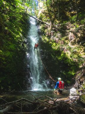
- R7: 90ft from dead snag DCL.
Exit[edit]
From the bottom of the big falls, follow the creek downstream to the road. It may be easier to exit the creek DCR and parallel it on a gentle downhill through largely open forest to the road. Once on the road, turn left and walk back to your shuttle car. Alternatively, exit the creek and thrash northeasterly back up to the trail (+230ft elevation gain).
Red tape[edit]
Note that FR 5290 is gated at the Gifford Pinchot boundary during the winter for wildlife (just outside of High Valley) and is not open until April 1st. The creek can still be accessed, but it might be a ridiculously long hike or bushwhack in.
Beta sites[edit]
Trip reports and media[edit]
Background[edit]
First descended by Kevin Clark, Wade Hewitt, Ashley Driscoll, and Trey Schutrumpf in June 2023.
There appear to be more drops on the creek downstream, although about half of them are on private property. It might be possible to run the first few on public land, then bushwhack out DCL/east about 0.5mi to reach FR 5290.


