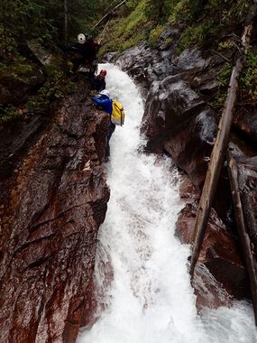
Ice Lake Creek (Lower)
| Rating: | |||||||||||||||||||||||||||||||
|---|---|---|---|---|---|---|---|---|---|---|---|---|---|---|---|---|---|---|---|---|---|---|---|---|---|---|---|---|---|---|---|
| | Raps:3, possible jumps, max ↨100ft
Red Tape:No permit required Shuttle:None Vehicle:Passenger Rock type:Cutler Sandstone | ||||||||||||||||||||||||||||||
| Location: | |||||||||||||||||||||||||||||||
| Condition Reports: | |||||||||||||||||||||||||||||||
| Best season: | Aug-Sep
|
||||||||||||||||||||||||||||||
| Regions: | |||||||||||||||||||||||||||||||
Introduction[edit]
Lower Ice Lake Creek is a good addition to Middle Ice Lake Creek.
The Confluence of Ice Lake Creek and Clear Creek produces Big Water, and is a great add-on after descending either Clear Creek or Lower Ice Lake Creek.
Approach[edit]
To start Lower Ice Lake Creek, either continue downstream during a descent of Middle Ice Lake Creek or follow the same approach for Middle Ice Lake Creek and reverse the exit, aiming toward the house size boulder.
To access just the Confluence of Ice Lake Creek and Clear Creek without descending Lower Ice Lake Creek, consider hiking the trail and rappelling R9, the last rappel in Clear Creek.
Descent[edit]
This numbering is a continuation of Middle Ice Lake Creek:
R10: Tree, canyon right, 100ft rappel. You should be able to stand in the pool to get off rappel. A tributary comes in at the bottom of the rappel on canyon left and dumps into the same pool you land in.
R11: Tree, canyon right, 35ft rappel.
R12: Tree, canyon left, 12ft rappel.
Shortly downstream, Clear Creek magnificently flows in from canyon left. The Confluence of Ice Lake Creek and Clear Creek follows, where there are no more rappels but you may need to set up a handline on some of the downclimbs in the flow. To remain in the watercourse is difficult for most. The size of the flow and the unseen nature of many slots and V's gives this section an "R" rating. Partner assist. Near the end of the technical canyon, a couple hundred feet before the bridge, you are rewarded by a wide and fairly deep circulating pool. There are several perches and differing heights from which to jump. Always test water depth prior to jumping.
