Iron Fork (North and South)
| Rating: | ||||||||||||
|---|---|---|---|---|---|---|---|---|---|---|---|---|
| | Raps:0-3, max ↨75ft
Red Tape:No permit required Shuttle:Required 45 min | |||||||||||
| Location: | ||||||||||||
| Condition Reports: | 23 Oct 2022
"Started from Crystal Lake just as dawn was breaking and got a great view over the valley on the approach which took 1:45. The canyon was at first scre |
|||||||||||
| Best season: | ||||||||||||
| Regions: | ||||||||||||
Introduction[edit]
This page will cover both North and South forks of Iron Fork in the San Gabriel Mountains. This canyon is easily broken down into three parts:
North Iron Fork has no technical challenges, just creek walking and some easy downclimbing. This was explored via a tributary canyon dropping in off the east side of Copter Ridge and depositing the team about halfway down the north fork, below the barren upper section.
South Iron Fork is accessed from the fire road along the ridge just north of South Mount Hawkins. There are 3 easy and rather pretty rappels in the canyon, followed by about 2 miles of hiking along a wide open canyon.
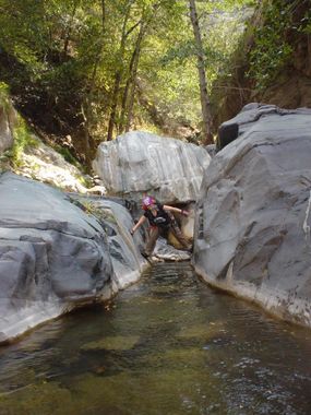
Where they converge into Iron Fork is the best part of the canyon. From here until East Fork, you get plenty of fun jumps, slides, and swims in beautiful clear water. Once while descending this, Amanda and myself (Taco) surprised a group of about a dozen Bighorn Sheep hanging out along a section just after a swim. This is one of the most fun areas I've been through in the San Gabes.
Approach[edit]
Park at the Crystal Lake parking lot, just north of Adam's Crystal Lake General Store and Cafe. For the North Fork, you can hike up north to Windy Gap, then along the PCT to the top of Mt Hawkins. Descend down Copter Ridge and descend via Wasp Gulch (unmarked), which is the major canyon coming off Copter Ridge's east side reaching about halfway down North Fork. There are probably still several Yellow Jacket nests in here so be careful.
For the South Fork, hike north from the parking lot to the fire road that reaches the summit of South Mount Hawkins. Take this up to the saddle just under 1/4mi north of the summit. From here, we descended slightly north down the ridges below.
Descent[edit]
Both forks are very similar with exception going to the 3 rappels in South Fork. These are located east and slightly north of the summit of South Mt Hawkins on a map. There are no anchor challenges or difficult sections in the canyon, and it is thus technically very easy. The lower section has many pools and slides as well as several sections where you can just float on your back for a little bit and relax. It is wise to plan to spend the warmest part of the day in this section.
Exit[edit]
Hike out to Heaton Flat for the car shuttle. A couple hours hike south along the East Fork.
Red tape[edit]
If you descend this canyon, please keep it as clean as possible. Please help remove any trash and unsafe rigging in the lower section of the canyon. This may involve packing out trash ropes and stuff like that, so plan accordingly.
