Jaguar Canyon
| Rating: | |||||||||||||||||||||||||||||||
|---|---|---|---|---|---|---|---|---|---|---|---|---|---|---|---|---|---|---|---|---|---|---|---|---|---|---|---|---|---|---|---|
| | Difficulty:3A III PG (v4a1 III) Raps:3-7, max ↨150ft
Red Tape:No permit required Shuttle:Required 20 min Vehicle:Passenger Rock type:Limestone | ||||||||||||||||||||||||||||||
| Location: | |||||||||||||||||||||||||||||||
| Condition Reports: | 30 May 2021
"Didnt have the Chorreadero approach kml so ended up a good 20 mins upstream of the start of said cave. water levels were high and chance of afternoon |
||||||||||||||||||||||||||||||
| Best season: | May-Oct
|
||||||||||||||||||||||||||||||
| Regions: | |||||||||||||||||||||||||||||||
Introduction[edit]
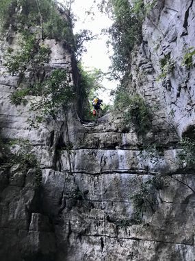
Although not a spectacular canyon itself, Jaguar is a great option to do the day after Chorreadero because it is dry and makes for a light day. In Chorreadero you will spend hours swimming in the water and come out like a prune so it is nice to plan a dry day afterwards. The highlight of Jaguar is the 3rd rappel, a 410 foot multi-pitch rappel. Otherwise, it is unremarkable except for the tremendous volume of trash particularly in the beginning half. The term trashwacking was thus born.
Approach[edit]
Park the exit vehicle at 16.75490,-92.9716. Drive a few short miles to a narrow pull-out on the left above a steep hillside at either the trash wall approach (16.7625, -92.9583) or the standard Chorreadero approach (16.76108, -92.95248).
Trash wall approach[edit]
On the west side of the narrow pull-out is a use trail that makes a sharp descent to the drainage for Chorreadero. Note the entrance for Chorreadero, then cross the drainage at the cave mouth.-92.95958.
Standard approach (recommended)[edit]
At the white gate, take the well-traveled trail toward the drainage via the GPS route shown for Chorreadero. The cave mouth is a few minutes downstream.
Both approaches[edit]
At the cave mouth, scramble up a small ravine RDC that starts on the right (up-canyon) side of the rock wall that marks the entrance to Chorreadero. The very faint and overgrown use trail becomes visible again near the top of this ravine and veers left. Take it to the first rappel at 16.76263, -92.95958.
Descent[edit]
- R1: Tree, 70 feet. Optional rebelay off bolts about 10 feet down. The transition from the first to second rappel does not have much space. It's recommended for all but the LAPAR to rappel off the tree. LAPAR should consider the rebelay due to possible pull issues.
- R2: Bolts Left, 60 feet.
- R3: 410 foot multi-pitch:
- First pitch is 30 feet from bolts left (can be downclimbed with skill and in dry conditions)
- Second pitch is from bolts with chain LDC (before the obvious drop off; keep an eye out for them on your way down pitch 1). It's 150 feet to a small ledge that can fit 3 people.
- Third pitch is 230 feet from 2 bolts. If you don't have a 230'+ rope, it may be able to be split into two: 130' to a large ledge with trees, fourth pitch is 100 feet from one of several trees.
- R4: Bolts Middle on the edge of the drop, 100 feet.
Exit[edit]
Hike down the drainage to the bathrooms at the bottom of Chorreadero. From the bathrooms to the parking lot is a 3 minute walk.
Red tape[edit]
As of May 2021, leaving your car unprotected on the side of the road at start of the approach seems pretty safe. The pullout was shared with other cars. To leave your car at the exit was 200 pesos per person (not per car), which is a lot of money for the area. Prices may change depending on who is manning the parking lot.
