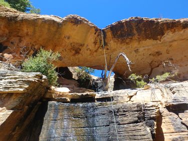
Jehovah 300 Natural Bridge (Sedona)
| Rating: | |||||||||||||||||||||||||||||||
|---|---|---|---|---|---|---|---|---|---|---|---|---|---|---|---|---|---|---|---|---|---|---|---|---|---|---|---|---|---|---|---|
| | Difficulty:3A III (v3a1 III) Raps:3, max ↨300ft
Red Tape:No permit required Shuttle:None Vehicle:Passenger Rock type:Sandstone | ||||||||||||||||||||||||||||||
| Location: | |||||||||||||||||||||||||||||||
| Condition Reports: | 11 May 2025
"Time reflects combination with Baby Buddah, waiting out winds, and pull issue (fiddle paracord snapped) on R3. All in all a short route.. R1 very |
||||||||||||||||||||||||||||||
| Best season: | Winter Spring Summer Fall
|
||||||||||||||||||||||||||||||
| Regions: | |||||||||||||||||||||||||||||||
Introduction[edit]
A classic Sedona hike to a very scenic overlook, followed by a short and challenging approach to a natural arch and scenic rappel sequence. protective layer recommended. followed by a descent back down into Mormon Canyon. We wanted to keep the theme of Mormon Canyon going so we went with Jehovah 300. I spotted this natural bridge on satellite about a year ago directly in the watercourse in the lower white rock section of the drainage. When we reached the bridge it became apparent it may be very possible that it has never been visited due to the very difficult nature of reaching the area. No signs of any anchors and no known info online of the natural bridge. Finding a natural bridge in itself gave this route a 4 star rating, otherwise I would say 3 stars if it wasn't for the bridge. Thankfully no ruins were encountered and disturbed on this route as well.
Approach[edit]
Begin at Brins Mesa trail head, work your way to the top of the mesa. Once you have reached the top of the mesa, take small social trail to the right heading in the direction (North) of Brins Overlook.
The trail follows the ridge with stunning views of Wilson Mountains South face. The More direct approach cuts across the flat mesa head west of the overlook. For the more scenic approach continue in the social trail to Brins Mesa Overlook. Once you top out on the mound scramble the Chunky red rock to the view point where you will have direct views of the 300' drop.
After a short break start cutting back southwest on the trail you came in on. If you follow the red rock cliff face left (WEST) of Jehova you will see a few small alcoves, and a prominent sandstone nose.
The approach gully starts just left or west of the nose, with a small rest ledge on the right within the first 100' of vertical. Tip toe over loose rock up the steep gully keeping a safe distance. Once the rock starts changing from red to light cream sandstone you have reached the top of the approach.
Continue North towards Wilson Mountain over the first drainage. A short walk over flat terrain will land you right on the Jehova Arch and r1.
Descent[edit]
R1: Natural bridge rappel. 70' over bridge. Small tree LDC. Anchor set 4/5/21. Please be mindful of vegetation growing on and around arch. Rapp over bridge staying clear of cacti in center.
R2: 300' off of large tree RDC. Mostly on wall, with a few small sections of free hang.
R3: 25' off pinch in boulder pile.
Exit[edit]
After last rapp gear down and head down the drainage, into main mormon wash. Follow the wash away from Wilson mountain and toward the fin. As the hillside on the right flattens out and the red rock cliffs of Brins ridge come into view on your right, turn off right and connect with main trail. Turn left onto the main trail and back to your vehicle.
Red tape[edit]
A Red Rock pass is required to park in the area for $5 per vehicle, per day - federal interagency passes are also accepted.
Beta sites[edit]
 sedonacanyoneering.com : Jehovah 300
Trip reports and media[edit]
https://www.facebook.com/media/set/?set=a.4204393839581024&type=3 https://youtu.be/HBOAwBeO4ww
https://m.facebook.com/story.php?story_fbid=10101793237030792&id=38100945
Background[edit]
First descent by Jay Wisocki, Todd Holmes and Erek Burek on March 28, 2021.
