Jerrara
| Rating: | |||||||||||||||||||||||||||||||
|---|---|---|---|---|---|---|---|---|---|---|---|---|---|---|---|---|---|---|---|---|---|---|---|---|---|---|---|---|---|---|---|
|
| |||||||||||||||||||||||||||||||
| | Difficulty:4B IV (v4a2 IV) Raps:9, max ↨197ft
Red Tape:No permit required Shuttle:None Vehicle:Passenger | ||||||||||||||||||||||||||||||
| Start: | |||||||||||||||||||||||||||||||
| Parking: | |||||||||||||||||||||||||||||||
| Condition Reports: | |||||||||||||||||||||||||||||||
| Best season: | Oct-Apr
|
||||||||||||||||||||||||||||||
| Regions: | |||||||||||||||||||||||||||||||

Introduction
Water Levels
Use the 215014 Bungonia Creek at Bungonia river gauge as a "proxy gauge" for Jerrara Canyon. Please understand it does NOT measure the catchment for Jerrara Creek, rather the neighbouring Bungonia Creek. Jerrara Creek is simply in the same geographical area, with a similar catchment size (approximately 60% that of Bungonia Creek at the gauge).
Accordingly, it is VERY POSSIBLE for Jerrara Canyon to have a different water level and conditions compared to Bungonia Main Canyon. Jerrara Canyon is notably more constrained than Bungonia Main Canyon, is less escapable, and has more exposure to flow and hydraulic hazards. The water quality in Jerrara Creek is often poorer than that in Bungonia Creek.
- <5 ML/d: a2 to a3, straightforward
- 5-10 ML/d: a3 to a4, some strong flows, some rigging in wet areas
- >10ML/d: Check Jerrara Falls for two ribbons (see below)
(As at April 2023 there's not a lot of data for gauge flows to aquatic rating.)
The catchment of Bungonia Creek at the Bungonia gauge is 164km2, as stated by WaterNSW. As a result after significant rain it can absolutely pump. It is considered a very good indicator of water in Bungonia Main Canyon, because it is geographically located immediately upstream of the canyon start at approximately -34.81958, 149.98852.
Water level reference photos
If in doubt, visually check the flow over Jerrara Falls at Jerrara Lookout (end of Adams Lookout Road, on the left) before committing to the canyon.

Avoid. Anchors will be in flow on main waterfall pitch, and VERY difficult to find, rig and manage. Wait until water is flowing only on the true left of the falls. Low flow on true right is manageable, but becomes increasingly difficult.

Typical low flow conditions. Note water is only flowing on true left.
Approach
Refer to the location map on the NPWS Bungonia National Park brochure

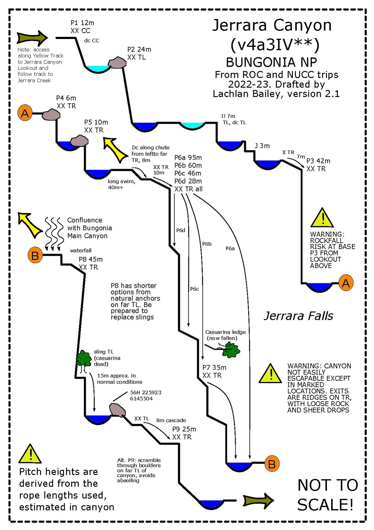
Follow the "Yellow Route" to the Jerrara Canyon lookout. Proceed westwards from the lookout along a defined track. The track finds a gulley, then descends down to Jerrara Creek.
Descent
Exit
Exit to the canyon is via the "Red Track" up Bretons Creek:
After the final abseil, follow Bungonia Creek downstream. At first progress is slow through the boulders and pools. After a long, narrowish pool, walk on the right bank to find vague paths along the valley floor. The canyon twists right, then sharp left. Find the Red Track true right. On the NPWS map, this is where the Red Track descends to Bungonia Creek, to the west of the marked "Slot Canyon". Proceed up the Red Track from here. Do not follow the Red Track along Bungonia Creek through the Slot Canyon (unless you want a very long day). The Slot Canyon is unmissable, a 15m slot through 150m+ sheer walls of limestone. It is spectacular and does not require any equipment to negotiate. If you continue downstream through the Slot Canyon, you can return via either the eastern arm of the Red Track, or the White Track from the junction with the Shoalhaven River. Approximate timings for a reasonably fit party in normal flow are: - Last pitch Bungonia Main to Bretons Creek: 1h - Bretons Creek to David Reid Carpark: 1h - Bretons Creek to David Reid Carpark via Slot Canyon and Red Track: 3-4h - Bretons Creek to David Reid Carpark via Slot Canyon and White Track: 4-5h
Note that there is reasonably okay and reliable water in Bretons Creek at the bottom of the Red Track (where you exit) issuing from the main Efflux of the caves. Be aware it does flow along the route of the Red Track, so there is a possibility of contamination.
The scramble up the ridge between Jerrara Creek and Bungonia Creek is extremely dangerous. It’s friable rotten shaley stuff with scrub and a sheer drop onto Jerrara Falls. The bushs are too weak and poorly rooted to build anchors, and the rock is too rotten for natural pro. And the whole time you are ascending a steep ridge above the waterfall with nothing to arrest a fall if you lose it.
Red tape
None
Beta sites
Trip reports and media
 YouTube.com : Richard Pattison, Jerrara Creek Canyon movie