A good beginner canyon close to Blackheath that can be done year-round thanks to negligible water flow and abseil anchors situated out of the flow. 7 abseils with only 2 mandatory. Canyon now extends to include Beauchamp Falls.
Quality
The canyon is rated 4 out of 10 on the Brennan Quality Scale.
David Noble rates the canyon 2 out of 5 for quality and Easy-Medium for difficulty.
Approach
By car
Parking spot located on Old Point Pilcher Trail at -33.664359, 150.324937 accessed via Point Pilcher Road, Medlow Bath
By foot
Walk north east along fire trail, which turns north
At -33.659410, 150.327579 there is a yellow sign warning of canyon dangers on a foot track off Old Point Pilcher Trail. Follow this track towards the start of the canyon at -33.659171, 150.329443
Older track notes describe turning right at "a star picket" that is no longer there. Others reference “a large live tree with a couple of holes burnt by fire in the trunk”. This description is also now out of date due to the 2019-2020 Bushfires.
Map
Map showing route in and out of Juggerls canyon
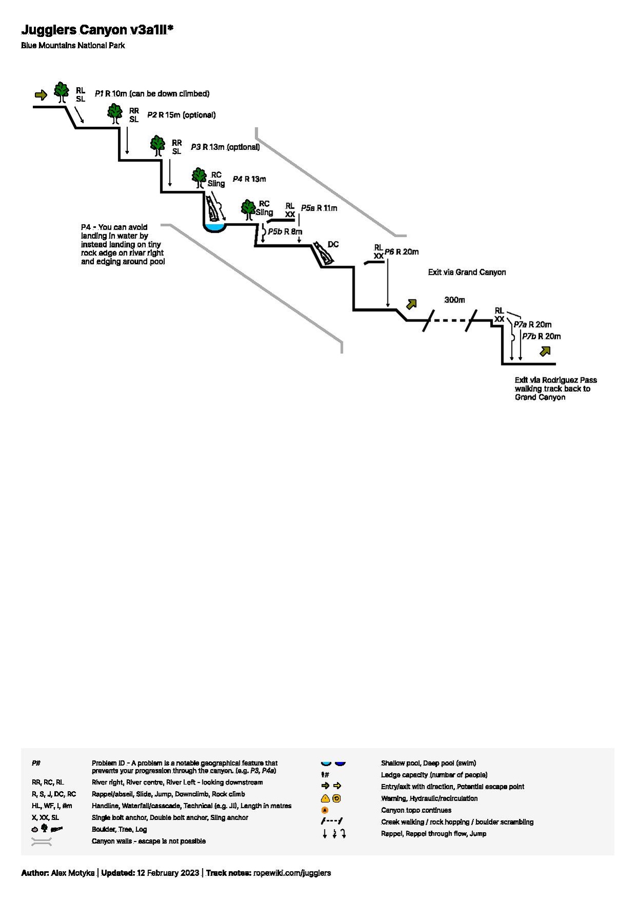
Descent
Simple and straightforward canyon with up to 7 abseils.
Wetsuits are optional
All but 2 abseils are optional and can be scrambled around/down
Distances between abseils are not large (no more than 100m excluding last abseil)
Route is well worn and easy to follow
Canyon does not have any significant water flow and can be done year round as a “dry” canyon
The pool at base of R4 can be avoided by edging along some very small ledges on the river right
6m hand over hand climb down between R5 and R6
Exit
At the bottom of Beauchamp Falls (R7) head upwards on river left (about 20m to the right of Beauchamp Falls) to find an old, unmaintained track just below the cliffs. Follow the cliff path back to the top of Beauchamp Falls, and upward.
Keeping river left, after about 150m the path will meet the larger Rodriguez Pass Walking Trail. Follow this maintained path until it intersects with the Grand Canyon Walking Trail (signpost).
Head upstream along the Grand Canyon Walking Trail until you reach the Old Point Pilcher Walking Track turn off, on the left when walking upstream at approx -33.657267, 150.324350. There is a yellow warning sign marking the Old Point Pilcher Route. The Pilcher track turns off the main Grand Canyon trail at the point where the Grand Canyon trail leaves the river to climb up the cliffs (the same place as the Grand Canyon canyon trip exit). Find the Pilcher trail near to the river as the Grand Canyon trail leaves the river. If you follow the Grand [ Canyon trail up the steps out of the river, you have gone too far. If you don't see the sign and well constructed steps, you're on the wrong route.
Proceed up through the cliffs and along Old Point Pilcher Walking Track on a well-cleared path. Pass the canyon entry path turnoff, and return to the car park.


 YouTube.com : Richard Pattison, Jugglers Canyon movie