Kaiser Creek
| Rating: | |||||||||||||||||||||||||||||||
|---|---|---|---|---|---|---|---|---|---|---|---|---|---|---|---|---|---|---|---|---|---|---|---|---|---|---|---|---|---|---|---|
| | Raps:10-13 rappels, max ↨180ft
Red Tape:No permit required Shuttle:Optional 8 min Vehicle:High Clearance | ||||||||||||||||||||||||||||||
| Start: | |||||||||||||||||||||||||||||||
| Parking: | |||||||||||||||||||||||||||||||
| Shuttle: | |||||||||||||||||||||||||||||||
| Condition Reports: | 19 Jul 2021
"I thought the beta was largely difficult to follow and left out a lot of details while being wordy on insignificant details. One important update is t |
||||||||||||||||||||||||||||||
| Best season: | July to Oct
|
||||||||||||||||||||||||||||||
| Regions: | |||||||||||||||||||||||||||||||
Introduction[edit]
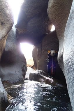
Probably the most impressive aspect of Kaiser Creek is how narrow of slots it cuts into the granite. This allows for some beautiful sections, and also even some fun stemming down climbs. Next is the weird rabbit holes and hidden passages that you can find beneath boulders and behind large slabs of rock that have fallen off into the canyon. These also form lots of sieves! Along with that there are lots of great waterfalls, rappels, and jumps like you would expect in a canyon in the Sierras.
Overall it makes for an awesome adventure when flows are low and reasonable (guessing 2-3 cfs?), and probably a death trap if it got much higher. There are lots of escape points, and the walls only remain high for sections, but if you can't imagine holding yourself up with all of the water in the canyon dumping on your head, think twice.
The best checkpoint for waterflow is at the pool where you start the descent, as shown on the map. You may still descend the canyon at high flow, just be prepared to bypass a lot of the falls.
Approach[edit]
After driving past Shaver Lake, turn left on Huntington Lake Rd down to the community of Big Creek. Past Big Creek, you'll hit another intersection with Stump Springs Rd on the left (not sure if there is a sign). Take the left and drive around 15 miles, looking for a dirt road through a burn area less than half a mile before Westfall Creek (which is signed). Drive down this road around a mile to a 180 degree turn on top of a ridge. Park here. You can also drop another car off another mile down the road at it's end if you want to save effort on the hike back up. It would be good to save a GPS point for the return trip.
From about this point hike west down to a gully, and then straight down to the creek.
Descent[edit]
Shortly down canyon you'll come up on the first rappel. It's short, and drops down under a chockstone into a sort of cave, then opens up into a shallow gorge.
After the gorge closes in, a fun jump over another sort of cave follows.
Further down the canyon gets choked in with boulders and slabs that have fallen in which make for exciting climbing and a pretty awesome section, but with little in the way of rappels. Eventually one sliding drop demands a rappel, and not long after the canyon opens up and at least momentarily changes character.
Large drops into some deep potholes follow. The first two of which make for great jumps. But this puts you into a spot with pretty much no anchor options. While we made jokes about some jumping options below here, it would be sketchy at best. Some bolts would probably add some fun to the route here, as the current route is to rappel off a tree past the jumps down from the left. Rappel shortly down to some other trees on a small ledge, then all the way down to a big pool which I want to say is around 180 feet total.
From here down another decent sized rappel with some potential rope pull issues exist. The next drop does not need to be rappelled. Look for the other route, you'll like it.
More rabbit holes, at least one short rappel follow until you get down to a very pretty right hand turn and the canyon opens up. A shortcut from here is up on the right along a slab. Downstream is another fun spot to jump, though you may want to scope out the landing. As it starts to slot back up, be careful. Things are about to get a little odd.
A short drop into a slot can be jumped, but it might require a different maneuver to set the next rappel, which is back upstream from the jump around a natural arch. This rappel drops down into a swirling pothole backed up by a giant boulder. The water all disappears into a seive somewhere below your feet. Best to watch your step as you take off rappel, and stay close to the downcanyon left wall to get to the left side of the boulder where you can climb out. In higher flow the sieve may be more dangerous so the other option is to rappel half way down the waterfall and pull yourself into and over the crack on the right. Send your best rock climber first and set up a meat guided rappel for those who aren't as nimble. From there down is relatively simple through a beautiful section of canyon to where it opens up.
One last gorge to go, and it's an awesome one. We were running short on time, and spotted a sieve that looked nastier than the previous one upstream, so decided to rappel in from some trees on the left below it. This worked out nicely, and gave us good views of the small section we missed. Going down the watercourse above would probably be awesome too, but could call for more bolts.
Below this rappel is a narrow section where it is not too difficult to stem over a waterfall which you almost certainly want to stay out of. If this made someone uncomfortable, an anchor could be set off of a kind of natural arch up on the right.
Nice hike from here out of the canyon. The lake is just downstream.
Exit[edit]
Move to the ridge on your left, and start hiking up! This is about some of the best cross country sierras hiking you could hope for. Occasional minor brush, and some sand, but that's about it! You'll want to head up the ridge, angling slightly right to hit the dirt road. Shouldn't have to walk into anything unpleasant. That's really all I can say. A GPS would be a good idea, don't pass the road on the right side of it. That would suck.
Red tape[edit]
Canyon is inside burn area of 2020 Creek Fire. Expect impacts to road, canyon, and surrounding area. Before going, review any relevant Sierra NF alerts and closure orders.
Beta sites[edit]
Trip reports and media[edit]
July 17, 2019

