Kalang Falls Canyon
| Rating: | |||||||||||||||||||||||||||||||
|---|---|---|---|---|---|---|---|---|---|---|---|---|---|---|---|---|---|---|---|---|---|---|---|---|---|---|---|---|---|---|---|
|
| |||||||||||||||||||||||||||||||
| | Difficulty:4B III (v4a2 III) Raps:14, max ↨180ft
Red Tape:No permit required Shuttle:None Vehicle:Passenger | ||||||||||||||||||||||||||||||
| Start: | |||||||||||||||||||||||||||||||
| Parking: | |||||||||||||||||||||||||||||||
| Condition Reports: | |||||||||||||||||||||||||||||||
| Best season: | Oct-Apr (avg for this region)
|
||||||||||||||||||||||||||||||
| Regions: | |||||||||||||||||||||||||||||||

Introduction
Kalang Wet follows the river and waterfalls, with anchors placed to maximise interaction with the flow. The canyon is runnable in medium flow, although some of the anchors place the abseiler in the full force of the falling water. In medium and high flows, the descent is a relentless series of waterfalls that will give the more experienced canyoner a fun and challenging trip. In high flow there is always the opt-out option to take the dry line for any of the abseils, using the old anchors away from the river. Kalang provides a possible fallback option for the experienced aquatic canyoner when the water in Kanangra Main and Danae Brook is too high.
Wetsuits are recommend.
If you're looking for the dry line notes refer to the abseil list at the bottom of the descent section below, and OZultimate's Kalang Falls track notes
Water Levels
- The catchment is ~4 km²
River gauges
Refer Kanangra_Main for gauge levels and grading. The gauge level can be taken down about 200 ML for Kalang, although above 1000 ML/d some of the abseils will be very challenging (but there's always the dry line bail-out).
Rainfall
Rain gauges can provide useful historical data for how much rain has fallen over a given period of time. There are no publicly listed online rain gauges or weather stations located at Kanangra. Rainfall for Kanangra reported by the Bureau of Meteorology is using data collected from sites over 40 km away from Kanangra and can be very unreliable proxies for rainfall at Kanangra.
The closest rain gauges for Kanangra include:
- INSWPORT16 via Weather Underground - approximately 22 km West
- Mount Boyce via Bureau of Meteorology - approximately 44 km North North East
- High Range via Bureau of Meteorology - approximately 40 km South South East
Approach
Park at Kanangra Walls. Take the tourist path to the view site. Just beyond the lookout, follow the signposted tourist path to Kalang Falls.
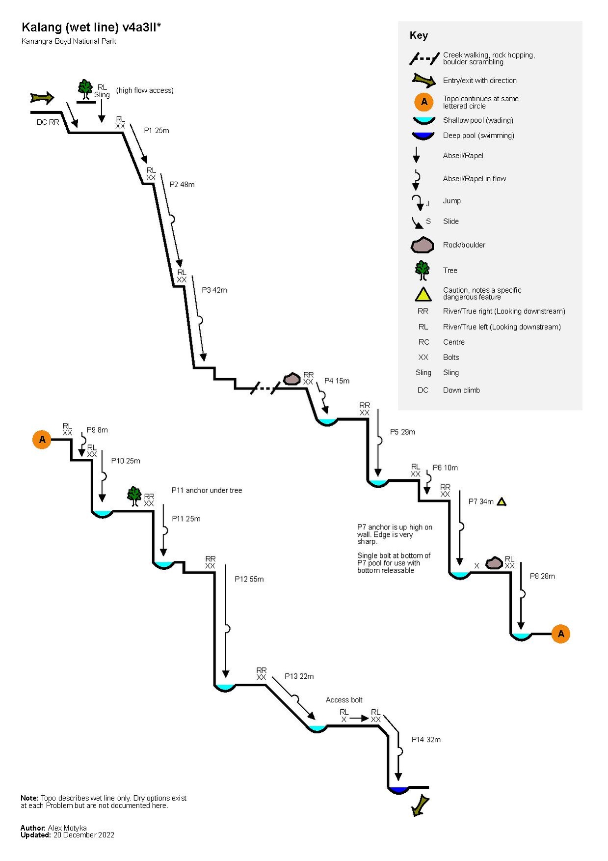
Descent
Wet line
| Number | Metres | Location | Note |
|---|---|---|---|
| Follow Kalang Falls path to river, cross to RL before left bend, cross to RR after same bend, scramble down once, cross river. High water, stay high RL, cut corner, abseil down from tree. Look for bolts RL. | |||
| 1 | 25m | RL | |
| 2 | 48m | RL | |
| 3 | 42m | RL | |
| Short walk past cascades. Traverse out RL, scramble down, rejoin river, cross to RR, scramble down, go into river | |||
| 4 | 15m | RR | Downstream side of big boulder |
| 5 | 29m | RR | 60m rope is good |
| 6 | 10m | RL | Follow flow to find next anchor |
| 7 | 34m | RR | Up high. Be very careful of the sharps on the rocks 1-2m from the anchor where the rope rubs. Bolt at bottom RR to set up bottom releasable. |
| 8 | 28m | RL | Downstream side of boulder |
| 9 | 8m | RL | Up high |
| 10 | 25m | RL | |
| Follow riverbed rightside to edge then look for anchor at left | |||
| 11 | 25m | RR | Under tree |
| 12 | 55m | RR | At spillover. Emergency bolts about 20m down RL (abseiler's right) |
| 13 | 22m | RR | Backward walk |
| 14 | 32m | RL | Down the chute up high (tallest person first). High water access anchor single bolt RL before the chute |
File:Kalang Falls Combined Abseils quick reference.pdf
Some of the abseils have sharp rocks. Manage your rope carefully.
Some of the abseils experience strong falling water when the water is up. Stay within your SRT rigging and abseiling abilities.
Dry Line
| Number | Metres | Location | Note |
|---|---|---|---|
| 0 | 15m | RR | Handline if required |
| 1 | 38m | RR | From tree |
| 2 | 40m | Bolts at edge to right | |
| 3 | 27m | RL | Traverse out left, then down. White tree, on edge, very loose approach |
| 4 | 45m | RL | Bolt or tree |
| 5 | 12m | RL | |
| 6 | 18m | RL | |
| 7 | 29m | RL | Large tree |
| 8 | 26m | RL | Bolts next to big waterfall |
| 9 | 27m | RL | Bolts on block, exposed |
| 10 | 40m | RL | Tree |
File:Kalang Falls Dry Abseils quick reference.pdf
Exit
Follow the track on Open Street Map, e.g. in Gaia, Pocket Earth or OutdoorActive. To describe: At the confluence of Kalang and Kanangra Creek, find the clear slab RR. Walk/scramble straight up from here, up Manslaughter Ridge. Veer very slightly left while ascending, but not too far that you are above the gully on the left. Head for the top.
Red tape
Beta sites
- https://ozultimate.com/canyoning/track_notes/kalang.htm Describes the dry line. Note that you should not use Murdering Gully as described on OZultimate - it is now overgrown and close to impassable.
Trip reports and media
 Wild Elly : Kalang Falls May 2022
- YouTube.com : Richard Pattison, Kalang Falls Canyon movie. To note that this is the dry line, not the canyon described on this page.
Background
First descent by Col Oloman and Gerry O'Byrne, circa 1961. (https://www.subw.org.au/archives/press-on-regardless/canyons-recalled/)
Kalang Falls canyon features in Dick Smith's 1966 canyoning video. Over time, the route was relocated away from the river. The line down the river was re-opened in 2019.