Lewis Creek
| Rating: | |||||||||||||||||||||||||||||||
|---|---|---|---|---|---|---|---|---|---|---|---|---|---|---|---|---|---|---|---|---|---|---|---|---|---|---|---|---|---|---|---|
| | Raps:3-6, max ↨120ft
Red Tape:No permit required Shuttle:None Vehicle:Passenger | ||||||||||||||||||||||||||||||
| Location: | |||||||||||||||||||||||||||||||
| Condition Reports: | 22 Jul 2024
"This is a great canyon with fun little slides and some great waterfall rappels. We dropped in a little later than the sneak approach (which looks comp |
||||||||||||||||||||||||||||||
| Best season: | Aug-Oct
|
||||||||||||||||||||||||||||||
| Regions: | |||||||||||||||||||||||||||||||
Introduction[edit]
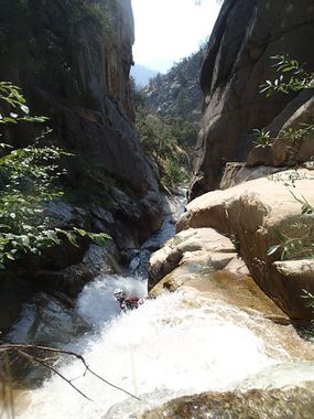
Lewis Creek is a short canyon in Kings Canyon National Park. The lower section involves a fun gorge with 3-5 rappels (water dependent) and should appeal to most canyoneers. The upper section, while less exciting, offers some fun water slides for those who want to spend the extra time.
Lewis Creek has a large drainage area, and is therefore not a great bet for early season. There is one section ~5-6 feet wide that could get dicey.
Approach[edit]
Park at Lewis Creek TH, and hike up Lewis Creek Trail.
After making it up all the switch backs, and then crossing through a bit of a draw, you should be able to make your way into the canyon cutting off the trail at ~5520 feet of elevation by dropping steeply down 400 feet of elevation.
Alternatively, continue up the trail and descend to the confluence of Comb and Lewis Creek once you get just above it. This immediately gives you some fun little slides. There is mostly stream walking below here, but it's pretty, relatively easy, and offers the occasional little gorge with another slide in there.
Confluence sneak: there's an easy sneak with very little bushwhacking if you go up trail for ~5-10 minutes. The scrub becomes obviously less thick and on the topo you will see the contour is less steep. You will see a confluence ABOVE where you enter; don't go into this drainage but this sneak will bring you in right below this drainage. Follow the gradual ridge down, first through brush and then into trees. Pick the most open path and follow the slope down and go to the left (towards the creek) as you walk. It takes ~5-10 minutes to descend this way.
Approximate start (leave trail ~5780 ft elevation) 36.81364, -118.68078
Enter Lewis (approximate) 36.81436, -118.68375
Descent[edit]
After the confluence, there were several small slides, but scout carefully. Take mostly the low angle slides and ride them with some caution, as with the cobbles that fill Lewis Creek, pools are often not deep.
R1: RDC; tree. ~60 feet into a nice water fall. This can be climbed around, but if flowing, it's a nice rappel.
R2: Middle water course; boulder. ~ 40 feet. Rappel this fall (RDC) or into the drier crack (LDC).
Original rappels
R3: LDC from a small tree growing from a ledge. ~160 feet; 2 stage. Rappel down a wide, flat wall ~30 feet on the first stage. Climb out RDC and continue the rappel through the water course; set length for the final little pool/pour off to rappel off into the creek below. It is possible to have someone sit at the lip between stage 1 & 2 and zipline packs if needed. (The first stage might be the original ~25 ft jump if you can climb down to a lower ledge; when flowing, this could be a risky climb into the water course. The jump would be ~30 feet, and would require precision. This pool was not very deep.)
R4: RDC cairn. ~50 feet. Next is a low angled rappel through a narrow slot. The cairn allows entrance to the water ~1/2 down the chute. Set length to rap off the end and swim out in the hallway.
R5: LDC boulder. ~130 feet. An ideal anchor for this rappel currently does not exist. Back up this anchor! This is another 2 staged rappel that travels from the center (stage 1) to RDC (stage 2).
As you continue to creek walk, look for a low angled channel with a large log over the creek. This is a final slide. Be careful to not hit your head on the log; the slide should shoot you under it. This is the final element of the canyon before the exit.
Exit[edit]
Below this rappel you walk down the creek until the gorge opens up. You'll see it get brushy below. From here, hike out, angle up and to the left, and you should easily find the trail.
