Lucas Creek (Lower)
Jump to navigation
Jump to search
Also known as: Lower Lucas Creek.
| Rating: | ||||||||
|---|---|---|---|---|---|---|---|---|
| | Difficulty:3A II (v3a1 II) Raps:2, max ↨60ft
Red Tape:No permit required Shuttle: Vehicle:Passenger | |||||||
| Location: | ||||||||
| Condition Reports: | ||||||||
| Best season: | ||||||||
| Regions: | ||||||||
GPS data automatically extracted from brennen.caltech.edu, please visit their site for more detailed information.
Introduction[edit]
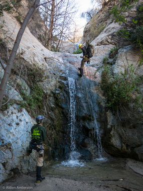
The Lower portion of Lucas Creek from below the Angeles Crest Highway down into Big Tujunga Creek. There are 2 short waterfalls of 25' and 20' at the end of the canyon that tend to be flowing in the Spring. To avoid most of the the bushwhack and poison oak in the upper non-technical section it is possible to drop in via a "sneak route" George Gulch, which also adds two worthwhile rappels of 60' and 95' and joins lower Lucas shortly above the two waterfalls.
Approach[edit]
Descent[edit]
Exit[edit]
Red tape[edit]
Beta sites[edit]
 Chris Brennen's Adventure Hikes (St Gabriels) : Lower Lucas Creek
