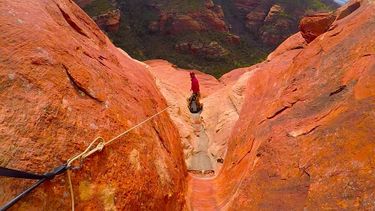
Magic
| Rating: | |||||||||||||||||||||||||||||||
|---|---|---|---|---|---|---|---|---|---|---|---|---|---|---|---|---|---|---|---|---|---|---|---|---|---|---|---|---|---|---|---|
| | Difficulty:3A II (v3a1 II) Raps:3, max ↨175ft
Red Tape:No permit required Shuttle: Rock type:sandstone | ||||||||||||||||||||||||||||||
| Location: | |||||||||||||||||||||||||||||||
| Condition Reports: | 23 Feb 2025
"Time reflects Magic and Windtalker. Magic was okay but not a great bang for the buck, really favor some of the others in heartwell. |
||||||||||||||||||||||||||||||
| Best season: | Year round
|
||||||||||||||||||||||||||||||
| Regions: | |||||||||||||||||||||||||||||||
Introduction[edit]
Magic Canyon is beautiful, with a massive giant horseshoe of sandstone that you drop into on rap 2, as well as slotted water grooves that you will hike in. Both the bigger raps are free hanging and incredible.
Approach[edit]
Park at Taylor Tank. Start at social trail to the left of the pond. Follow social trail and kml track into Hartwell canyon.
Hike up Hartwell until the second major side canyon on the right. Hike up this past the bottom of the Windtalker and Magic final raps. Take this gully after Magic final rap uphill following cairns until they end, and then following the watercourse and slickrock to the top and over to Magic.
Note: You will pass Windtalker en route to Magic on the slickrock section up top. Continue to Magic, the next significant water course/ V-notch for the start.
Descent[edit]
All rappels are mostly free hanging.
R1: 175' off of bolts LDC. Two ledges.
R2: 30' off tree LDC. 15' free hanging.
R3: 170' off of bolts LDC. 140' free hanging.
Exit[edit]
Follow side canyon RDC through bushy drainage to same wash you came in on. Exit on same social trail returning to Taylor Tank and your vehicle. Please stick to the route and kml track being mindful of sensitive vegetation, and archeological sites.
Red tape[edit]
Beta sites[edit]
 sedonacanyoneering.com : Magic
Trip reports and media[edit]
Background[edit]
Please preserve arche sites. First Descent by Garrett Bennett and Ron Paradis in February of 2021.
