Magic Box Canyon
| Rating: | |||||||||||||||||||||||||||||||
|---|---|---|---|---|---|---|---|---|---|---|---|---|---|---|---|---|---|---|---|---|---|---|---|---|---|---|---|---|---|---|---|
| | Raps:16 - 22, max ↨98ft
Red Tape:No permit required Shuttle: Watercraft:Yes | ||||||||||||||||||||||||||||||
| Location: | |||||||||||||||||||||||||||||||
| Condition Reports: | 30 Aug 2025
"Great day with a friendly flow in a beautiful canyon. It felt like the lower side of the moderate-low today. Water wasnt super cold, but 5/4 wetsuit |
||||||||||||||||||||||||||||||
| Best season: | Aug-Sept
|
||||||||||||||||||||||||||||||
| Regions: | |||||||||||||||||||||||||||||||
Introduction[edit]
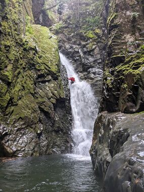
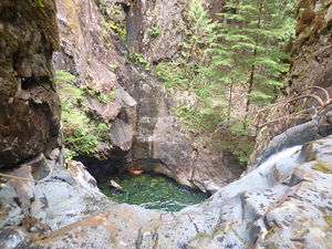
Magic Box Canyon (officially Box Canyon Creek) is a big, scenic canyon that features rapid-fire rappels and seemingly endless deep, beautiful pools. While the movement and technical requirements of this canyon at moderate flow are beginner-friendly, the scale and commitment are not. It demands a high level of team efficiency with a 2+ hour approach, 20+ drops, slippery terrain, prolonged exposure to cold water, and a 1.5 hour exit. For their efforts, teams are rewarded with fun rappels in friendly flow, an exciting slide, several good jumps, and stunning scenery.
Box Canyon Creek (not to be confused with Box Creek, a tributary of Monmouth Creek just 20km to the NE) is located near Howe Sound within Sunshine Coast Regional District, British Columbia — approximately 24km SW of Squamish and 22km NNW of Horseshoe Bay. The drainage basin is on the east side of Box Canyon Peak (1379m), and the creek flows east to its confluence with McNab Creek.
This canyon uses many natural anchors such as logs, root balls, trees, and rock pinches. Teams should come prepared with plenty of webbing and quick links, and the first team through in a season should bring bolts. Much of the canyon’s walls are sheer, and when log jams are washed away, few anchor options remain. Due to the remoteness and wilderness character of this canyon, teams should be prepared to problem-solve.
Approach[edit]
While roads do exist to reach Magic Box, they are not open/accessible to the public.
Water crossing[edit]
Most parties will need to cross Howe Sound. Here are some options:
- Water taxi
- from Squamish: 20min trip. Contact Squamish Marine Services.
- from Horseshoe Bay: 40min scenic trip, winding around Gambier Island and Anvil Island. Contact Mercury Transport (confirmed 3 Sep 2023), Sunshine Coast Water Taxi, or Cormorant Marine.
- Sea kayak
- Put in at Porteau Cove and head directly west for 11km, skirting around the eastern edge of Anvil Island. Note that there is vessel traffic, and the sea can get very rough when the winds pick up. Not recommended for anyone lacking skills and experience in proper sea kayaking.
Road walk[edit]
There are many large animals that inhabit this area: bears, cougars, elk, and wolves. Take care, and ideally travel with a group.
- From the McNab Creek dock, follow the flat McNab FSR 10209 01 road heading north to the bridge over Box Canyon Creek. This is the waterflow checkpoint and where you will exit the creek after the descent. (2.4km)
- Proceed past the powerhouse and substation (staying left at the fork), then turn left onto Box Canyon FSR 10209 02 to begin your ascent. (1km)
- Box Canyon FSR 10209 02 quickly turns south, then switches back north, then south again as it climbs up to 560m elevation. At this point, the road gradually bends West. Proceed past a small structure (easily missed) and a large clearing on the left to where the road meets the forest on the left side. (4.2km)
Bushwhack[edit]
Enter the forest, quickly losing elevation as you descend the steep and mostly open forest. Cliffs are present on both sides, so use caution in choosing your route. Placing a rope around a tree or downed log near the bottom can be useful as a handline. (220m, -80m elev.)
Alternate Bushwhack (unconfirmed)[edit]
This is an unconfirmed, but likely much less steep option, with the tradeoff of an additional 300m of stream walking.
- Continue on the flat road. (240m)
- Enter the forest, and bushwhack to the creek. (100m, -30m elev.)
- Stream walk. (300m, -40m elev.)
Descent[edit]
R1 - 6m/20ft DCL webbing around boulder, or downclimb from canyon left to right (needs two bolts for convenience/high water)
R2 - 14m/45ft DCL two unlinked bolts
Stream walk 300m/1,000ft
R3 - 26m/85ft DCR webbing around fallen log 6m/20ft back. This is not a slide. This rappel follows an angled chute into a large, cold, deep infinity pool that’s about 30m/100ft long. A bolt is installed at the bottom ledge of the chute DCR to help protect access to the R4 anchor at the pour-over.
R4 - 15m/50ft DCR unlinked bolt
Carefully traverse over or around an unstable log jam.
R5 - 15m/30ft DCL webbing around tree
R6/J1 - 8m/25ft human anchor or jump 5m/15ft into a large, deep pool. Clearing a jagged ledge is not very difficult, but the launch is slippery, and clearing the ledge is mandatory.
R7/S1 “Decapitation Slide” - 13m/40ft DCL two unlinked bolts. Sadly in 2024 the log has slipt into the pool blocking the bottom of the slide. It's now a rappel.
R8/J2 - 5m/15ft human anchor, or climb up DCL to jump 7m/20ft
R9/J3 - 8m/25ft DCR two unlinked bolts, or 8m/25ft technical jump into 2.5m/8ft deep pool with boulders on either side 1m/3ft below the water. Landing zone is 1.3m/4ft wide.
Travel 60m/200ft through a scenic corridor to a short but impassable waterfall.
J4 - 3m/8ft traverse DCR on easy scramble terrain to a flat launch. Jump to the center of the pool, avoiding a log in the center, and boulders on the right.
J5 - 5m/15ft DCL, or downclimb DCR to 3m/8ft jump
R10 - 14m/45ft DCR two unlinked bolts on a mossy outcrop. Complete as two-stage rappel, or rappel 8m/25ft and then jump into the large, deep pool.
R11 - 17m/55ft webbing around log. Two-stage rappel - 5m/15ft into pool followed by 12m/40ft vertical pitch.
R12 “The Grotto” - 23m/75ft DCL two unlinked bolts. Vertical pitch into a massive grotto with 150m/500ft walls.
R13 - 6m/20ft DCL single bolt, down short drop as you exit The Grotto.
R14 “The Magic Crack” rebelay sequence. This is the technical crux of the canyon.
- 30m/100ft DCL webbing around tree. Scramble up DCL 15m/50ft to reach the tree which is situation just downstream of the pour-over. Optionally, send a confident climber to place a fixed line to the anchor tree to aid progression for the rest of the group. Beware of loose rock on the descent, and traverse downstream (rappeler's right) to reach the rebelay station.
- 20m/60ft DCL two unlinked bolts with ring hangers. The rebelay is on a smooth, mostly vertical wall with no ledge to stand on. Descend into the crack and swim the long, deep pool.
- On the first descent, rather than scrambling up DCL, the team rappelled off a log into the pool created by a large, house-sized boulder, and climbed up DCR under the club-shaped log (webbing remains on that log). In 2021, the space below the log has been filled in, and moving a team up and over the log would have been extremely challenging. Additionally, the FD team’s 2nd pitch in the crack was from a jammed root ball that has since been washed away.
- In order to descend in the watercourse, well-thought out, sustainable anchor stations would be required.
R15 - 23m/75ft DCL unlinked bolts. Rappel in fun, friendly flow around a corner. Earn points by going down first and taking pictures of your friends as they descend possibly the most photogenic waterfall of the canyon.
R16 “Log Deviation” - 8m/25ft DCR webbing around log. Rappel into a big deep pool. In 2019 and 2021, the end of a log could be used as a deviation for a cleaner rappel and to avoid rope abrasion.
R17 “Crooked Falls” - 12m/35ft webbing around log. Rappel down a slippery slab. The water makes a distinctive 90 degree turn creating a sideways rooster tail.
R18 - 7m/20ft DCL webbing around tree 5m/15ft up
R19 - 10m/30ft webbing around a pinch in the watercourse
R20 - 26m/85ft DCR unlinked bolts. Out of the flow.
R21/J6 - 10m/30ft DCL webbing around boulder, or 8m/25ft jump
R22 - 12m/35ft DCL tree, or downclimb and partner capture (needs two bolts for convenience/high water)
Exit[edit]
Stream walk[edit]
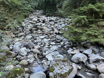
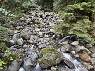
The final rappel is followed by a long stream walk with lots of boulder hopping, downclimbing, and a few pools. When you see the power lines overhead, you're about 5-10 minutes from the bridge. Stay in the watercourse all the way to the bridge for a clean exit up cement blocks DCL. Most groups will take about 45-75 minutes depending on energy level. (675m, -125m elev.)
Road walk[edit]
From the bridge, turn right on McNab FSR 10209 01 and proceed south to the McNab Creek dock. (2.4km)
Red tape[edit]
The McNab Creek dock and the area along McNab FSR 10209 01 going north is private land all the way to Box Canyon FSR 10209 02. See ParcelMap BC for parcel details and boundaries.
Beta sites[edit]
Trip reports and media[edit]
Background[edit]
Scouting and first descent[edit]
This location was scouted by Michael Henson and Clare Stenham-Brown in 2019. The first descent was made on September 5th, 2019 by a group including Michael, Clare, Andrew Humphreys, Becca Polglase, Brent Roth, Kevin Steffa and Ben Thomas.
Cell service[edit]
Cellular phone service is available at the McNab Creek dock (Verizon subscriber confirmed 3 Sep 2023).
Geology[edit]
Many different rock types are present within the canyon, dating to the low to mid-Cretacious (145~100 Mya). The upper part of the creek is primarily quartz dioritic intrusive rocks (MKqd), and the lower part is marine sedimentary and volcanic rocks of the Gambier Group (lKGsv). Some impressive folding and vertical beds can be observed. A structural geologist may take keen interest in this locale.
Box Canyon Hydroelectric Project[edit]
The Box Canyon Hydroelectric Project is among the most hydraulically complex of any run-of-river hydro project in North America, if not the world. It includes a main intake on Box Canyon Creek and intakes on two of its tributaries, all just upstream of the descent route. How this might impact flows during canyoning season is unknown to canyoners at present.


