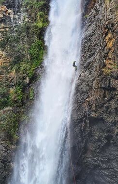
Manning Gorge (Upper)
| Rating: | |||||||||||||||||||||||||||||||
|---|---|---|---|---|---|---|---|---|---|---|---|---|---|---|---|---|---|---|---|---|---|---|---|---|---|---|---|---|---|---|---|
| | Raps:4, max ↨203ft
Red Tape: Shuttle:None Vehicle:4WD Rock type:Basalt | ||||||||||||||||||||||||||||||
| Start: | |||||||||||||||||||||||||||||||
| Parking: | |||||||||||||||||||||||||||||||
| Condition Reports: | |||||||||||||||||||||||||||||||
| Best season: | Oct-Apr (avg for this region)
|
||||||||||||||||||||||||||||||
| Regions: | |||||||||||||||||||||||||||||||
Introduction[edit]
Manning River Gorge is an excellent trip in the Barrington Tops area. There are 4 abseils, with the most impressive being the 62 metre Manning Falls, plus a nice little canyon section at the Black Hole and a number of slides.
Gauge: River Gauge: 208029 Manning @ Leslies Bridge
- < 80 ML/d: a3
- > 80 ML/d: a4
Approach[edit]
Proceed to the parking place noted in the summary (which may not be reachable by vehicle, depending on the vehicle and condition of the road). Leading steeply down the ridge is an old logging trail. Follow this until it levels out. on the right is another old logging trail at MGA659788 dropping steeply off the ridge towards the river. Follow this trail down until near the bottom where you can drop off to your left and scramble steeply down to the river.
Descent[edit]
| Rap | M | L/R | Description |
|---|---|---|---|
| From the entry point scramble , swim and climb downstream a short distance and you will come to a set of cascades dropping into the Black Hole. | |||
| R1 | 40m | TL | Bolts on sloping ledge by sling around big detached rock. Descend on TR till you reach a small cove on the right immediately before the next waterfall. There is an access/redirect bolt TR for higher water |
| R2 | 10m | TR | Bolts high up on the wall. Single access bolt to reach them. Use only the bolts that do not spin, currently 2 need to be grinded out. |
| Swim through short canyon section, followed by various slides | |||
| R3 | 60m | TL | Bolts on the edge of the vegetation. A redirect for high flow 12m down on small ledge. Very wet abseil, be sure to manage bags with the flow. Into large pool. Rope pull easier from far side. |
| Exit pool on TL, careful of spillover. On high flow, scramble down TL well away from river on rock. | |||
| R4a | 18m | TL | Sling around tree, away from river into the pool after the 2 lower waterfalls. |
| On low flow it is possible to abseil the two lower successive waterfalls. Cross the spillover and: | |||
| R4b | 12m | TR | Single bolt, on vertical wall |
| R5b | 12m | TR | Single bolt, on vertical wall around corner into pool. |
| About 500 metres of swimming, scrambling and rock hopping downstream until Kangaroo Creek comes in on your left. |
Exit[edit]
Follow the steep spur between Kangaroo Creek and the Manning River up, keeping close to where the spur drops steeply into Kangaroo Creek on your right, keep following the spur and you will come back to where you started. (There is a massive landslide on the Southeast side of the spur now)
Red tape[edit]
Beta sites[edit]
Trip reports and media[edit]
Background[edit]
First Descent - Laurie Alderton Chris Alderton, Steve Cooper Heather Reid


