Marten Creek (Alpine Lakes)
| Rating: | |||||||||||||||||||||||||||||||
|---|---|---|---|---|---|---|---|---|---|---|---|---|---|---|---|---|---|---|---|---|---|---|---|---|---|---|---|---|---|---|---|
| | Raps:6, max ↨164ft
Red Tape:No permit required Shuttle: Vehicle:Passenger Rock type:Granite | ||||||||||||||||||||||||||||||
| Location: | |||||||||||||||||||||||||||||||
| Condition Reports: | 14 Sep 2018
"Biked up to the intersection between Marten and Taylor trails. Rainy and wet, so we moved kind of slow. Canyon was excellent, with a long bit of bould |
||||||||||||||||||||||||||||||
| Best season: | July-Sept
|
||||||||||||||||||||||||||||||
| Regions: | |||||||||||||||||||||||||||||||
Introduction[edit]
Don't confuse with Marten Creek (North Cascades).
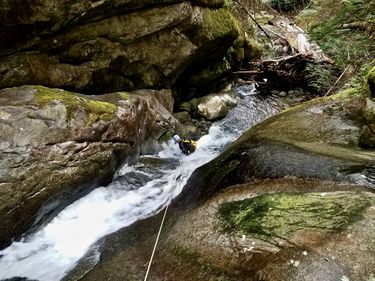
Marten Creek is located within Mt. Baker-Snoqualmie National Forest and begins in the Alpine Lakes Wilderness in the Middle Fork Snoqualmie River watershed. It is a tributary to the Taylor River and is sourced by Marten Lake. The interesting features of this canyon occur in an upper section, dominated by low-angle granite slabs and blocky waterfalls, and a lower section, with steep curving slides. These are separated by a long boulder-hopping section with lots of fallen wood.
Marten Creek is characterized by an upper section immediately following the outlet of Marten Lake, where the stream flows over expansive granite slabs likely carved by alpine glaciers in this valley. Around R2, the stream begins to follow a valley carved by river erosion. This valley conspicuously follows a single, nearly vertical set of joints (planar cracks) in the granite bedrock for most of the way between R3 and R4. This creates some spectacular vertical and overhanging walls that are veiled by misting trickles of water in late summer.
While the canyon has little in the way of technical challenge, its fascinating geologic history, spectacular views of the Taylor River valley, and fun slides in the lower section make it a great adventure.
Caution: The upper slabs are covered in moss and other fragile vegetation that could easily fall victim to excessive trampling. Please be careful to leave as little trace as possible and respect the wilderness character of this canyon.
This Marten Creek is a tributary to the Taylor River in Mt. Baker-Snoqualmie National Forest and should not be confused with the Marten Creek that is a tributary to the South Fork Stillaguamish, in Mt. Baker National Forest.
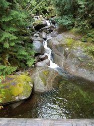
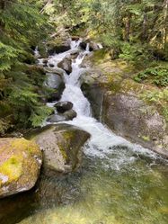
Waterflow reference picture is taken at the bridge where the Taylor River Trail crosses Marten Creek.
Approach[edit]
Take exit 34 from I-90 and take 468th Ave SE north. Turn right onto SE Middle Fork Rd (NF 5600) and take all the way to the Snoqualmie Lake/Taylor River Trailhead. You will need a Northwest Forest Pass to park at the trailhead.
Hike (or bike) the Snoqualmie Lake/Taylor River Trail 3 mi (5 km) to Marten Creek. Take a look at the creek on the bridge before heading back up the trail (the way you came) to the Marten Creek Trail, which heads uphill west of the creek. Take the trail 1 mi up to Marten Lake. Enter the creek just downstream of the lake.
The Taylor River trail is open to mountain bikes and is easy-moderate singletrack depending on recent washouts.
Descent[edit]
Note: The upper section of the creek is in the Alpine Lakes Wilderness. The water from the lake can be warm, and the flow is lower than in the lower reaches of the creek. The rappels in this section of the creek can be done with retrievable anchors, leaving no trace in this highly protected area. There is a lot of moss on the granite slabs that could be damaged by repeated wear. Please be cautious when descending this section.
The creek begins on low-angle granite slabs. The rock is fairly grippy and most sections can be downclimbed.
R1: 15-30m depending on choice of anchor. - Used retrievable anchor on tree on R.
A tributary comes in on DCL at bottom of rappel, running off the same slab as this drop.
R2: 30m - Used retrievable anchor on tree on L.
A tributary comes in DCL as a waterfall just downstream of the drop.
R3: 20m - Used retrievable anchor on tree on R.
Walk through a long section of boulders, exiting the Alpine Lakes Wilderness.
R4: 20-30m depending on choice of anchor. - Used webbing wrapped around a boulder pinched on R and rappelled through flow. Fun rappel-slide. Pool is deep and a short jump can be had if desired by climbing up the left side of the pool.
R5: 30m - Used webbing wrapped around small alder on L.
R6: 50m - Used retrievable anchor on large alder on L. Fun rappel-slide.
Exit[edit]
After reaching the bridge across Marten Creek on the Taylor River Trail, hike or bike back to the trailhead following the same route used on the approach.
Red tape[edit]
A Northwest Forest Pass or similar federal lands pass may be required at the newly created (as of September 2018) Taylor River trailhead.


