Mary Jane Canyon
| Rating: | ||||||||
|---|---|---|---|---|---|---|---|---|
|
| ||||||||
| | Difficulty:3A III (v3a1 III) Raps:10, max ↨120ft
Red Tape:No permit required Shuttle: Vehicle:Passenger | |||||||
| Location: | ||||||||
| Condition Reports: | 15 Feb 2025
"Total time 1:20. Extremely brushy approach made for slow going. Canyon was pretty clogged too until the final multi-step sequence. I downclimbed every |
|||||||
| Best season: | ||||||||
| Regions: | ||||||||

Introduction
There are two approaches to this canyon. The simplest and easiest is to park your car next to the bridge and just do the lowest four rappels, exiting where you started. The other, described on Brennen's page, is the longer with considerably more bushwhacking and route-finding for one or two more rappels, and requires a car shuttle. From the top, there is a pretty intense bushwhack as you drop-in, down a steep slope with poison oak and thorny vines, a really bad combo. It is perhaps one of the worst sections of poison oak in the area. This is only in the upper, non-technical section and once through this is a pleasant canyon relatively brush-free with nice rappels. If you do the lower section only, you can hike up-canyon to a gorgeous waterfall, and what we used to call the "King Kong tree", which may not still be there.
For the upper, I would HIGHLY recommend NOT dropping in straight down the steep slope and into the canyon, but instead taking the ridge DCR (34.2761, -118.1927) and then drop into the canyon after this thorny, poison web of evil. I haven't done the ridge approach, but from in the canyon this looks like the way to go. It will require some navigation skill.
After doing the canyon several times, I feel the lower is the better option. It may be possible to bushwack up above the first rappel from the bottom too, but it hasn't been done yet.
Approach
Descent
Exit
Red tape
There are "No Parking" signs at the natural parking area by the gate, which has been blocked with mounds of dirt. Parking enforcement is lax, but if you don't want to risk it, drive a hundred feet or so up the road to where there are no such signs.
Beta sites
 Chris Brennen's Adventure Hikes (St Gabriels) : Mary Jane Canyon
- Super Amazing Map : Mary Jane Canyon
Trip Reports and Media
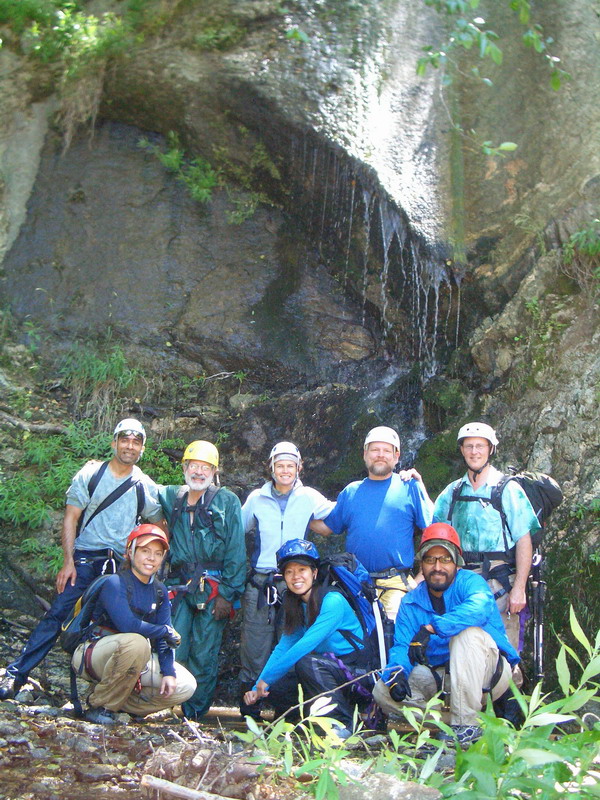
 2005 Rendezvous Crowd at Mary Jane
ropewiki.com/images/e/ee/Mj000017.JPG
this is the correct picture
2005 Rendezvous Crowd at Mary Jane
ropewiki.com/images/e/ee/Mj000017.JPG
this is the correct picture
Background
First descent of the lower canyon was on 4/24/2005 by Jane Fontana, Mark Fitzsimmons, Ken King, Dave Campen, and Dave L. Smith Jr. It was done the second time on June 23, 2005 as a rendezvous canyon. We called it Mary Jane because of the remnants of an illegal pot grow on the plateau, and because it was Jane's idea. First canyoneering descent of the upper section was on Dec.9, 2006, by Ken King, Mark Fitzsimmons, Jane Fontana, Matt Maxon, Nivalda Rodrigues-Pinguet, James Valdovinos, Jim Fayollat and Chris Brennen. This canyon burned in the 2009 Station Fire and the bushwhack at the head of the canyon is now full of poison oak and thorny vines.