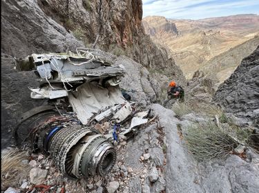
Mayday Canyon
| Rating: | |||||||||||||||||||||||||||||||
|---|---|---|---|---|---|---|---|---|---|---|---|---|---|---|---|---|---|---|---|---|---|---|---|---|---|---|---|---|---|---|---|
| | Difficulty:3A IV (v3a1 IV) Raps:7-10, max ↨110ft
Red Tape:No permit required Shuttle:None Vehicle:Passenger | ||||||||||||||||||||||||||||||
| Location: | |||||||||||||||||||||||||||||||
| Condition Reports: | 21 Dec 2024
"The approach indeed require route finding, but its not as terrible as people describe it to be. We went in with a scavenger hunt mentality and were |
||||||||||||||||||||||||||||||
| Best season: | Oct-Apr (avg for this region)
|
||||||||||||||||||||||||||||||
| Regions: | |||||||||||||||||||||||||||||||
Introduction[edit]
This canyon is less impressive than its neighbor Portal Canyon, but the wreckage of an A-10 Thunderbolt that crashed in 2001 make it a unique and worthwhile experience for those who might find visiting the wreckage interesting. The approach for this canyon is both grueling and dangerous because of the steep ridge climb with loose rocks that can be kicked down both onto other members of the approaching team, or onto another group already in the canyon. Appropriate caution should be taken.
Mayday Canyon is within the the Federally designated Paiute Wilderness Area.' Please abide by the laws of Wilderness Areas. That means it is illegal use motorized equipment (I'm looking at you power drill).
Approach[edit]
From the Virgin River Gorge Campground (Cedar Pocket), it is necessary to drive south on I-15 all the way out of the Gorge in order to turn around and head north. Heading north on I-15 through the Gorge, watch for a small (40ft) hill on the right side of the road 2 miles after entering the Gorge. Pull of the road to park in a large dirt and gravel area just past the hill.
Although this canyon is rated A, it is necessary to cross the Virgin River twice: once to approach the canyon, and once to return to your vehicles. Make sure that the flow is not too strong before attempting these crossings. Because the rest of the trip is usually entirely dry, it is highly recommended to take steps to have dry shoes and socks for use after crossing the river. Crossing the river in bare feet may be possible, or it may be useful to bring an alternate pair of shoes to cross the river in, and then leave on the opposite bank of the river in the bushes during the canyon.
Begin hiking up the wash -- you will return back down this wash at the end of the canyon. About 0.8 miles past the river, the canyon starts to narrow in the section labeled Bonus Canyon. There is a 40' 5.3 climb to continue up canyon in the water course, or you may turn left to bypass this section of the approach; the bypass route is marked on the KML. Turn right at the three-way intersection between the last rappel of Portal Canyon, the exit of Mayday canyon, and a third drainage heading to the right and head up this third drainage. Shortly after this point, turn left to head steeply up hill toward the crest of the ridge and then continue up hill along the path of least resistance.
After approximately 900ft of elevation gain on a 36% grade, you will reach an Unexploded Ordinance sign that may be fallen down. After another 150ft of elevation gain at the same grade, pieces of wreckage will start to appear and the climb will become steeper. At this point, rock fall becomes a serious issue and everyone in your group should review rock fall procedures beforehand. The grade also increases to nearly 60% making the next 500ft of elevation gain more of a scramble than a hike. This 500ft of gain contains numerous pieces of wreckage, however, and your group may want to take this section slowly for both safety and exploration reasons.
Shortly after the wreckage starts to become less common, turn left to contour toward a small ridge on the far side of a drainage adjacent to Mayday Canyon. On the far side of this ridge, descend carefully to the floor of Mayday Canyon keeping rockfall issues in mind.
Descent[edit]
Exit[edit]
Mayday Canyon merges with the other drainages, including Portal Canyon near its exit. Simply follow this large drainage back the way you came back to the river and your vehicle. If you bypassed the drop in Bonus Canyon on the approach, you should instead descend through Bonus Canyon on the exit rather than taking the bypass back.
Red tape[edit]
Beta sites[edit]
 Las Vegas Slots Book by Rick Ianiello : Mayday Canyon
Trip reports and media[edit]
Background[edit]
Here is some history on the A-10 Thunderbolt crash. A recommended read before descending this canyon. http://www.lasvegassun.com/news/2001/sep/05/downed-pilot-was-getting-experience-in-a-10-fighte/
A little more info from a geocashing site: http://www.geocaching.com/geocache/GCGC55_warthog-down?guid=f275258d-e54d-47ff-90f6-61a36b3e5271
