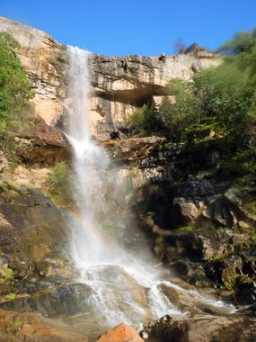
Mill Creek (Lower, Sierra National Forest)
| Rating: | |||||||||||||||||||||||||||||||
|---|---|---|---|---|---|---|---|---|---|---|---|---|---|---|---|---|---|---|---|---|---|---|---|---|---|---|---|---|---|---|---|
| | Raps:5-10, max ↨180ft
Red Tape:No permit required Shuttle:Required 25 min Vehicle:Passenger | ||||||||||||||||||||||||||||||
| Start: | |||||||||||||||||||||||||||||||
| Parking: | |||||||||||||||||||||||||||||||
| Shuttle: | |||||||||||||||||||||||||||||||
| Condition Reports: | 27 May 2019
"Flow fairly high and water was fairly cold, combined with poor weather: 50s, overcast and off-and-on rain, made for pretty poor day. The poison oak ha |
||||||||||||||||||||||||||||||
| Best season: | BEST in Spring
|
||||||||||||||||||||||||||||||
| Regions: | |||||||||||||||||||||||||||||||
Introduction[edit]
Mill Creek is a longer creek with a fraction of the flow of the nearby Jose_Creek. Mill Creek is likely best descended when flow in Jose Creek is too high to be safely descended.
Approach[edit]
Park the approach vehicle at the Mill Creek bridge on "Old Railroad Grade Rd". There is space for one, possibly two, cars off the road on the south side of the creek. The road to this point is very rutted.
Descent[edit]
Start by climbing/sliding down the slope under the bridge. Rap 1 is about 100 yds down from the bridge.
Rap 1 is a 120ft waterfall with many tree anchors (and dead brush) 10-20ft back from the edge.
The first of several long bushwhacking sections follows Rap 1.
Rap 2 is the second of two large-ish waterfall stages, the first of which is easily downclimbed. Rap 2 has many tree options DCR for a 30ft rappel, or can be bypassed further DCR.
Rap 3 is 60ft at the next big waterfall, anchors include a solid pair of chock stones under a flake DCC. This is also likely bypassable DCL in drier conditions.
Rap 4 is at a multi-stage waterfall with two logs in the two major narrow fall stages. Rap down one stage and then down a second short drop, about 70ft in total. The second stage may be downclimbed with a careful partner assist DCL in lower water conditions.
Rap 6 is 100ft from a shrub/tree DCC to a wider landing in the waterfall series.
Rap 7 is 90ft from a tree DCR (an extended anchor was left here because the tree anchor is up a steep slope).
Rap 8 is a 170' multi-stage waterfall with an initial free rappel of about 100ft. This is probably the most amazing waterfall in the canyon. Bolts DCR of main waterfall. First descent rigged to a mazanita tree DCL and avoided the main flow, but rappeled through trees. This rap could likely be broken up into two stages by landing and rerigging off a tree DCL (easier) or DCR (harder).
Rap 9 is 70ft from a chock rock DCL.
Exit[edit]
After the last rap, continue down Mill Creek until it joins Jose Creek. Enjoy the view of the waterfalls in the technical section of Upper Jose Creek. Follow Jose Creek down to Million Dollar Rd, climb up to the road, and hike left down the road 750ft through the gate to your exit vehicle.
Red tape[edit]
Canyon is inside burn area of 2020 Creek Fire. Expect impacts to road, canyon, and surrounding area. Before going, review any relevant Sierra NF alerts and closure orders. See also Sierra NF road conditions.
Beta sites[edit]
Trip reports and media[edit]
Background[edit]
From the exit bridge across Jose Creek, one can see several waterfalls up a canyon. These waterfalls are part of the technical section of Mill Creek; the technical section of Jose Creek is not visible from the bridge, as it the canyon bends up to the right (south) looking upstream.
