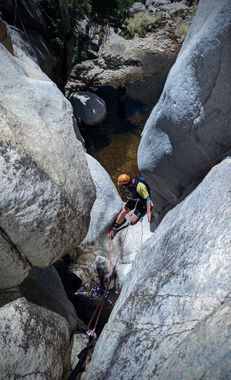
Montrose Canyon
| Rating: | |||||||||||||||||||||||||||||||
|---|---|---|---|---|---|---|---|---|---|---|---|---|---|---|---|---|---|---|---|---|---|---|---|---|---|---|---|---|---|---|---|
| | Difficulty:3B II (v3a2 II) Raps:4, max ↨60ft
Red Tape: Shuttle:None Vehicle:Passenger | ||||||||||||||||||||||||||||||
| Location: | |||||||||||||||||||||||||||||||
| Condition Reports: | 19 Jan 2026
"Quite an unremarkable canyon for the Catalinas, some sweet rock in sections but the pay to play ratio is a bit off for the lack of unique landscape. S |
||||||||||||||||||||||||||||||
| Best season: | Spring
|
||||||||||||||||||||||||||||||
| Regions: | |||||||||||||||||||||||||||||||
Introduction[edit]
Like Upper Romero Canyon, but - less. The approach hike is shorter with less elevation gain; there is some decent scenery, and although the canyon doesn't have as much appeal as Romero it's quite fun with good waterflow.
Drive to Catalina State Park via SR77 (Oracle Road) and drive all the way to the end at Romero Canyon trailhead. The park fee is currently $10 per single passenger vehicle, $20 per multipassenger vehicle.
Approach[edit]
Cross the wash and head up the trail turning left immediately thereafter at the first trail junction with the Birding Trail, then at the .6 mile mark stay right at a second junction with Canyon Loop Trail following signs for Romero Canyon Trail as you go to continue up the mountain to the east. After a total of 2.5 miles; at a ridge before Romero Canyon pools, depart from the trail to the right to make your way down the brushy slope to the canyon bottom.
Descent[edit]
Accessibility of some of the anchors in this canyon may change with water levels and flow conditions - be prepared to construct anchors if flow is high.
Some minor pools can be avoided after entering the canyon; after some boulder hopping you will reach the first rap.
R1: 60 feet from a pinch point in the watercourse.
R2: 50 feet from another good pinch point canyon left, or from a pinch in the watercourse on the right.
R3: 25 feet from a pinch point into a deep pool.
R4: 35 feet from a knot chock in a crack on the right.
Continue down canyon through more pools until you reach a fairly obvious spur trail on canyon right that leads up the the main Romero Canyon trail.
Exit[edit]
Follow the well traveled Romero Canyon trail the remaining one mile back to the parking area.
