Moonflower Canyon
| Rating: | |||||||||||||||||||||||||||||||
|---|---|---|---|---|---|---|---|---|---|---|---|---|---|---|---|---|---|---|---|---|---|---|---|---|---|---|---|---|---|---|---|
| | Difficulty:3A II (v3a1 II) Raps:1-2, max ↨220ft
Red Tape:No permit required Shuttle:None Vehicle:Passenger Rock type:Sandstone | ||||||||||||||||||||||||||||||
| Location: | |||||||||||||||||||||||||||||||
| Condition Reports: | 22 Mar 2025
"All bolts and anchors were present and in good condition, including the first bolt, to avoid the first pothole. Both rappels were exactly the length o |
||||||||||||||||||||||||||||||
| Best season: | Fall, Summer, Spring
|
||||||||||||||||||||||||||||||
| Regions: | |||||||||||||||||||||||||||||||
Introduction[edit]
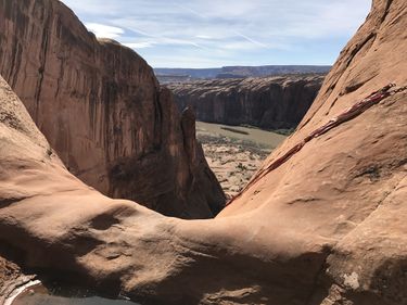
How many Grade I canyons do you find two 200 foot rappels, one with a 185 foot free-hang overlooking the Colorado River reflecting the cliffs behind it and the other about an 80 foot free-hang, on the approach stunning views to the East of the La Sals, the entire town of Moab laid out below you with the buttes of Arches NP to the north, and an easy approach and even easier exit.
Approach[edit]
Descent[edit]
See condition reports for important information regarding rappel lengths. Note that during an initial descent by the Moab guidebook author pre-dating the bolts, a marginal deadman anchor was used at the final lip, with some excitement as the 200-foot-rope tails were 2 feet off the ground and the drop unknown. The current bolt anchors may be positioned differently such that a longer rope or extension is warranted.
Exit[edit]
There is a descent trail to the left after the 200 ft rappel.
Red tape[edit]
Canyoneering book recommends not rappelling into Moonflower Canyon after the 200ft rappel since you'd be rappelling onto campsites. Indeed I found no slings in this area and walked off instead. This might no longer be an issue as the campsites are being relocated Spring 2017.
Beta sites[edit]
 Climb-Utah.com : Moonflower Canyon - Moab
 Moab Canyoneering Book by Derek A. Wolfe : Moonflower Canyon
 RoadTripRyan.com : Moonflower Canyon
 Climb-Utah.com : Moonflower Canyon - Moab
