Mormon Canyon (Upper)
| Rating: | |||||||||||||||||||||||||||||||
|---|---|---|---|---|---|---|---|---|---|---|---|---|---|---|---|---|---|---|---|---|---|---|---|---|---|---|---|---|---|---|---|
| | Difficulty:3A III (v3a1 III) Raps:2_4, max ↨310ft
Red Tape:No permit required Shuttle:Optional 15min Vehicle:Passenger Rock type:Sandstone | ||||||||||||||||||||||||||||||
| Location: | |||||||||||||||||||||||||||||||
| Condition Reports: | 14 Sep 2025
"An excellent day through Mormon Canyon. We took the North Wilson trail approach, and deviated somewhat from the published route by dropping into Mormo |
||||||||||||||||||||||||||||||
| Best season: | Mar-May;Nov
|
||||||||||||||||||||||||||||||
| Regions: | |||||||||||||||||||||||||||||||
Introduction[edit]
Upper Mormon Canyon is atop Mt. Wilson in Sedona, AZ and drops onto Brins Mesa. The canyon hosts four rappels, two of which are optional. Map above shows 3 options for approach; 2 shuttles (Wilson Mtn & North Wilson) and also a loop using Rainbow Ridge. More information about the Rainbow Ridge approach can be found on Sedona Canyoneering (https://www.sedonacanyoneering.com/mormon-monster).
APPROACH
Hike to the top of Mt. Wilson via the Wilson Mountain or North Wilson Trail, having left a shuttle car off of Park Ridge Drive in Sedona at the Brins TH. The main drainage is Upper Mormon that flows off of Mt. Wilson heading West and dropping onto Brins Mesa. Take the northern most drainage/feeder as it is cleaner to access the main drainage this way versus the small drainage located more so to the south or the one to the east of R0. Head down this drainage into the main canyon.
Descent[edit]
Rappel 0 (80' - Optional): This rappel is skipped if you follow the recommended route on Sedona Canyoneering (https://www.sedonacanyoneering.com/mormon-monster). Starting from the northern most feeder drainage, optional rap about 80 feet (a slightly brushy rap and optional, but we used a retrievable sling and it saved us a bunch of way more brushyness as to walk around this drop...) into the main drainage atop Mt. Wilson. From there head down canyon through intermittent slot that has a few down-climbs that are basic and can by bypassed.
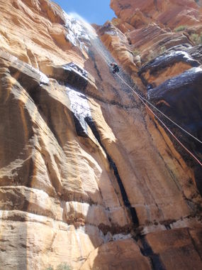
Rappel 1 (310'): Arriving at the big drop, there are now 2 solid bolts above and behind the keeper pool close to the edge. The new bolt location makes the edge transition easy, which is appreciated if your nerves are janglin' from the 310' exposure. Edge protection is a good idea but not required if you inspect between rappelers and potentially reset rope as needed. The top 10-15' of the rappel are vertical, with the remaining 300' free-hanging into the beautiful red rock bowl. Typically this rappel is in a fair flow/waterfall from March through April or whenever there is a warm day with snowmelt coming off of Wilson. When that is happening its a beautiful addition to the rappel. A 100m pull-cord did the trick using a fiddlestick. Pull will be even more difficult in wet conditions.
Rappel 2 (120' Optional): Once through the Monster rap, downclimb steep slabs for 100'; feet staying on the right side of the red rock bowl, or rap this slab about 120' from a pine tree located near the top center of the slab if icy or concerned about this downclimb/scramble. End the rap before the lip feeding into a hard to avoid pool.
Rappel 3 (125'): One more mandatory 125' rappel awaits. You can use a deadman anchor and rap the watercourse direct, or use an anchor off of the large pine tree to canyon left of the watercourse. If using the pine tree as an anchor, be mindful of brush along the rappel and some stout locust at the bottom which will easily tangle your rope and rappelers. Trailing your rope here is a good idea. There are also 2 bolts RDC at this location. Getting to them is easy but a no-fall zone, which qualifies as "slightly sketchy". The tree remains an option for those that don't want to deal with that.
Exit[edit]
Follow Mormon Canyon watercourse a good distance for one of the easiest watercourse exits in Sedona. After that, meet up with Brins Mesa Trail, and a short jaunt to the Brin's Mesa trailhead.
Red tape[edit]
Red Rocks pass required for parking at exit trailhead and at start trailhead. $5 per day with pay station at exit or start. Annual National Park Pass will also work.
Beta sites[edit]
 sedonacanyoneering.com : Mormon Monster
 Super Amazing Map : Mormon Canyon - Upper
 HikeArizona.com : Mormon Canyon
 OnRopeCanyoneering.com : Mormon Canyon
Trip reports and media[edit]
Background[edit]
This canyon was first descended by Garrett Bennett and Eric Jansen of Sedona, AZ in March of 2011. During that descent there was no trace of anchors or anchor material nor any other signs that we were able to ascertain of any descent. The canyon was done clean using only natural anchors and bolts were not placed anywhere (including the big rap). We had no issues and used retrievable edge pro to prevent core shots. Being able to adapt in canyons in this way is critical. It was eventually poorly bolted by an unknown party and then properly rebolted by locals. As canyoneering these routes has become so popular this was the best thing to do no doubt.
