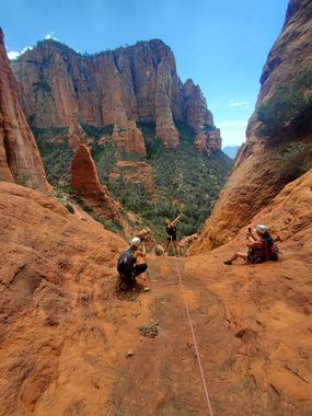
Mormon Spires Canyon
| Rating: | |||||||||||||||||||||||||||||||
|---|---|---|---|---|---|---|---|---|---|---|---|---|---|---|---|---|---|---|---|---|---|---|---|---|---|---|---|---|---|---|---|
| | Difficulty:3A III (v4a1 III) Raps:4, max ↨200ft
Red Tape:No permit required Shuttle:Optional 15min Vehicle:Passenger Rock type:Sandstone | ||||||||||||||||||||||||||||||
| Location: | |||||||||||||||||||||||||||||||
| Condition Reports: | 6 Dec 2024
"R3 Replaced to a single loop of black webbing around the boulder, please maintain. R4 will does not quite need replacing but is tied with two short pi |
||||||||||||||||||||||||||||||
| Best season: | Winter Spring Fall
|
||||||||||||||||||||||||||||||
| Regions: | |||||||||||||||||||||||||||||||
Introduction[edit]
A Beautiful canyon featuring big drops in quick succession with large spires of rock in the background!
Using the rainbow ridge approach this route can be done as a loop from Brins Mesa trailhead.
Approach[edit]
Hike up Brins Mesa Trail. Once atop the ridge, turn right, following ridge and the social trail along Brins Mesa.
Before getting to the red rock, turn off trail and bushwhack down into slick rock drainage below.
Continue up other side, hiking up steep slippery gully to the top.
From here Follow KML and rainbow ridge approach, bushwhacking over to Jehovah 300 arch.
From there, bushwhack some more traversing East over to the next drainage and R1.
Descent[edit]
R1: 200' tree LDC to large ledge.
R2: 70' large Juniper tree RDC.
R3: 185' boulder set 30’ back
R4: 90' Juniper tree RDC into possible pool which could be avoided by stopping short on first ledge.
Exit[edit]
Follow lower Mormon Canyon drainage (which is mostly brush free) to a point where you can get back up to Brins Mesa Trail (see GPS file)
Red tape[edit]
Red Rocks pass required for parking at exit trailhead and at start trailhead. $5 per day with pay station at exit or start. Annual National Park Pass will also work.
Beta sites[edit]
 sedonacanyoneering.com : Mormon Spires
Trip reports and media[edit]
https://www.facebook.com/media/set/?set=a.3062714227082330&type=3 https://youtu.be/UKvbnnBWc4o
Background[edit]
First Descent by Dinna Marquez, Josh Marks and Jay Wisocki
Rainbow Ridge Sneak approach via Brins Mesa makes this route a loop along with Upper Mormon, and Jehova 300. Sneak approach discovered by Eric Moorcroft.
Kml updated by Emoorcroft 2020.
