Mosaic Canyon (South-Southwest Fork)
| Rating: | |||||||||||||||||||||||||||||||
|---|---|---|---|---|---|---|---|---|---|---|---|---|---|---|---|---|---|---|---|---|---|---|---|---|---|---|---|---|---|---|---|
| | Difficulty:4A IV (v4a1 IV) Raps:11, max ↨250ft
Red Tape:No permit required Shuttle: | ||||||||||||||||||||||||||||||
| Location: | |||||||||||||||||||||||||||||||
| Condition Reports: | 19 Feb 2017
"Approach is long and lowers my opinion of this canyon quite a bit. Perhaps this holds true for all of the Mosaic forks.. We were a possible second |
||||||||||||||||||||||||||||||
| Best season: | Nov-Mar (avg for this region)
|
||||||||||||||||||||||||||||||
| Regions: | |||||||||||||||||||||||||||||||
Introduction[edit]
First descents by Scott Swaney.
Mosaic Canyon South-Southwest Fork
First descent December 26, 2011.
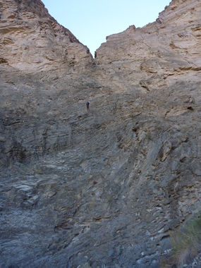
NOTE: joins with SSW fork and see report - MOSAIC from the west side - This was a hike-up also along the ridge for over 3000 vertical feet and then we dropped into the new canyon fork. There we encountered a massive vertical drop in the canyon of almost 600' in three rappels in rapid succession. The longest drop was 250'. A very spectacular portion of the canyon. Lower down the canyon we came across another big drop, but only completed a portion of it as a rappel. Very limited anchor material and approaching darkness dictated that we downclimb a steep gully to finish the descent. This proved to be a very worthy canyon and came as a surprise to us as to its quality. This canyon had a total of 11 new rappels.
Mosaic Canyon Southwest Fork
First descent March 16, 2013.
Second day, Saturday, we completely another new fork of Mosaic Canyon, above Stovepipe Wells. We had a climb of over 3000' to get there. A group of us had done a new fork a few months ago, and this was another fork that had not been completed. The new fork we did eventually ran into the fork done earlier down canyon. We also added another rappel that had not been done the 1st time, in the lower part of the canyon. It completed a 440 foot vertical wall done in two 220' rappels. The 2nd rap was done on a new knot block anchor not seen, or found, the first time. There wasn't much anchor material to work with at that ledge halfway down that 440' drop. Now a much better route. Straight down that big canyon wall.
PHOTO: ON THE 250' RAPPEL OUT OF THE NOTCH
Approach[edit]
Descent[edit]
Exit[edit]
Red tape[edit]
Beta sites[edit]
 Super Amazing Map : Mosaic Canyon - SSW Fork
Trip reports and media[edit]
TWO REPORTS FOR THIS CANYON:
First Descent trip 12-26-11:
Another ascent trip 3-16-13:
Background[edit]
Originally explored by Scott Swaney and team on 12-26-11 - SEE TRIP REPORT ABOVE for canyoneers
