Needle Rock Narrows
| Rating: | |||||||||||||||||||||||||||||||
|---|---|---|---|---|---|---|---|---|---|---|---|---|---|---|---|---|---|---|---|---|---|---|---|---|---|---|---|---|---|---|---|
| | Difficulty:2A I (v1a1 I) Raps:0
Red Tape:Permit required Shuttle:None Vehicle:Passenger | ||||||||||||||||||||||||||||||
| Location: | |||||||||||||||||||||||||||||||
| Condition Reports: | 13 Mar 2025
"Did not realize this was a listed route, we did the google earth gamble and found this little gem. We drove up the wash in a 4Runner and parked at the |
||||||||||||||||||||||||||||||
| Best season: | winter, spring, fall
|
||||||||||||||||||||||||||||||
| Regions: | |||||||||||||||||||||||||||||||
Introduction[edit]
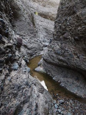
A quick, but interesting and scenic section of non-technical conglomerate narrows near the Verde River. Easy, almost zero exposure bridging and climbing moves add some fun and will keep your feet dry if the slot is holding water.
How you get there depends a bit on where in Phoenix you are coming from. Navigate to the Needle Rock Beach Recreational area at 33.772111, -111.664977; drive all the way down Needle Rock Road to park at a sandy parking lot at the end of the road.
Approach[edit]
From the parking area, hike up Camp Creek wash which is also 4x4 trail 413 - or of course you can drive right up to the canyon if you have the proper vehicle. Hike northwest for 1 mile on this sandy, gravel road to enter the canyon from the bottom. Locating the correct wash to begin to hike up is the only trick, the wash leading to the narrows is a nice, clear gravel driveway of a wash with very little brush with and a floor the same shade of tan and orange as the road - as opposed to the gray rocks in the washes of a few dead ends in the area.
Descent[edit]
Explore the narrows climbing around and over the shallow pools as you go until the canyon opens up at a confluence of the upper branches.
Exit[edit]
Return the way you came.
Red tape[edit]
A Tonto pass ($6 per day) is required for use of this area - day use only.
