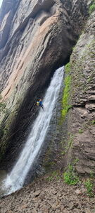
Ninety Degree Creek
| Rating: | |||||||||||||||||||||||||||||||
|---|---|---|---|---|---|---|---|---|---|---|---|---|---|---|---|---|---|---|---|---|---|---|---|---|---|---|---|---|---|---|---|
| | Raps:2-3, max ↨45ft
Red Tape:No permit required Shuttle:None Vehicle:Passenger Rock type:Volcanic Tuff | ||||||||||||||||||||||||||||||
| Start: | |||||||||||||||||||||||||||||||
| Parking: | |||||||||||||||||||||||||||||||
| Condition Reports: | |||||||||||||||||||||||||||||||
| Best season: | Jun-Sept, BEST Jun-Jul
|
||||||||||||||||||||||||||||||
| Regions: | |||||||||||||||||||||||||||||||
Introduction[edit]
Ninety Degree Creek is a tributary to Williams Creek and is named for its short drainage that turns a sharp 90 degrees at each waterfall. This beta includes a loop adding in a few waterfalls in Williams Creek, the main drainage.
These are technically two canyons, but Williams Creek is so short it is added here as an alternate approach, which simply makes the loop more interesting.
Approach[edit]
Drive: 23 miles on Piedra Road to the North from Highway 160 on the West side of Pagosa Springs. Piedra Road turns into FS 600 then 631. Follow the subtle right turn onto FS 636 to the Middle Fork Piedra River. Park at the end of the road at the Williams Creek Trailhead. This is the same trailhead as Winston Creek.
Williams Creek Approach:
Hike: the Williams Creek Trail for one mile, depart the trail and climb down a scree slope to Williams Creek below. Descend Williams Creek.
Ninety Degree Creek Approach:
Hike: south along the East side of Williams Creek following game trails that start to gain a little elevation. A junction from an old trail is marked on the GPS map. Continue up the hill to the northeast, but it is possible to circle around the back side of the hill and save a bit of elevation by not topping out.
Approaching just Ninety Degree Creek can be done by reversing the exit trail.
Descent[edit]
Williams R1: 125' for a 30' drop from a rock pinch in Canyon Center
Williams DC: 15'
Williams DC: 10'
Walk downstream to the bottom of Ninety Degree Creek and hike to the top
Climb over the first chute waterfall to an anchor for R1
Ninety Degree R1: 40' from a tree on Canyon Right
Ninety Degree R2: 80' for a 45' drop from a rock or log at the bottom of R1
Ninety Degree DC: a long low angle chute after R2
Exit[edit]
Hike fishing trails for one mile down Williams Creek to the Trailhead.
Red tape[edit]
Beta sites[edit]
Trip reports and media[edit]
12 July 2024: First known descent. Ira Lewis, Eric Moorcroft, Kegn Moorcroft, Wayne Herrick, Carl Bern, Scott Smith


