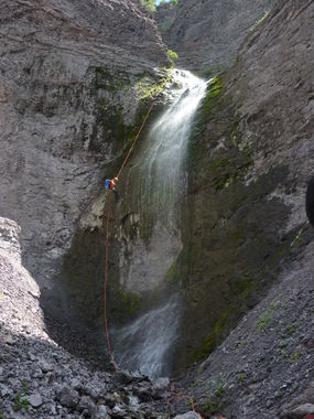
Oben Creek
| Rating: | |||||||||||||||||||||||||||||||
|---|---|---|---|---|---|---|---|---|---|---|---|---|---|---|---|---|---|---|---|---|---|---|---|---|---|---|---|---|---|---|---|
| | Raps:7, max ↨140ft
Red Tape:No permit required Shuttle:None Vehicle:4WD - High Clearance | ||||||||||||||||||||||||||||||
| Location: | |||||||||||||||||||||||||||||||
| Condition Reports: | |||||||||||||||||||||||||||||||
| Best season: | Jun-Oct
|
||||||||||||||||||||||||||||||
| Regions: | |||||||||||||||||||||||||||||||
Introduction[edit]
Portions of this canyon lie within the Uncompahgre (formally Big Blue) Wilderness area. Please practice leave-no-trace techniques to keep this canyon pristine.
Although the longest rappel is 100 feet, you will want more than 100 feet on the pull side to facilitate the rope pull. Can be done with a 200 foot rope is webbing is attached to the pull. Also, this rope length is reliant on a root anchor.
Note that the largest drop is a confirmed nesting site for the black swift, a rare bird in Colorado that only lives near (and often within) misty waterfalls. The Audubon Society, Forest Service and the Colorado Division of Wildlife has expressed concern for the welfare of the black swift, so much so that a planned, city-sponsored via ferrata in the Box Canyon in Ouray was scrapped to protect the bird and its habitat (that is also why no canyoning is done there). They are also concerned with the impact of canyoning to this species. In fact, the CDoW lists the black swift as a "Species of Greatest Conservation Need" in Colorado, and the Forest Service lists it as a "Sensitive Species" within Region 2 (which includes Colorado). The rappel line will take you close to some nests. Watch where you place your feet, and try to steer clear of any small holes or cavities behind the waterfall. Failing to do so could mean the closure of not just this canyon, but most other San Juan canyons - please have respect for this beautiful, waterfall-dwelling bird!
This waterfall is a confirmed nesting site for the Black Swift, listed as a Species of Special Concern by the U.S. Forest Service and U.S. Fish and Wildlife Service. The swifts migrate from Brazil annually to occupy this site from late May until late September, raising a single chick. The swifts are susceptible to disturbance from human activities near their nests, including noise and movement, direct disturbance or destruction of their nests, and trampling of vegetation. Canyoneering/climbing at this waterfall during the Black Swift nesting season (late May - late September/first frost) is likely to cause direct damage to nests, eggs, and young, and disturb adult swifts enough to cause them to abandon their nest and offspring. Click here for more information on the Black Swift.
