Paraiso Escondido
| Rating: | |||||||||||||||||||||||||||||||
|---|---|---|---|---|---|---|---|---|---|---|---|---|---|---|---|---|---|---|---|---|---|---|---|---|---|---|---|---|---|---|---|
|
| |||||||||||||||||||||||||||||||
| | Raps:4-5, max ↨72ft
Red Tape:No permit required Shuttle:None Vehicle:Passenger Rock type:Volcanic | ||||||||||||||||||||||||||||||
| Location: | |||||||||||||||||||||||||||||||
| Condition Reports: | 30 Dec 2021
"Flowing perfect level. Pools all filled. No hydraulic hazards. First anchor has been removed, but this rappel can easily be bypassed on right to do th |
||||||||||||||||||||||||||||||
| Best season: | Any
|
||||||||||||||||||||||||||||||
| Regions: | |||||||||||||||||||||||||||||||

Introduction
One of the best canyons in the area! Paraíso Escondido, not commonly done due to a lack of local canyoneers, is an incredible slot with mossy green walls, crystalline water, and fun bolted rappels. Every canyoneer will like this one. Be ready for very cold water, especially in winter.
The rating reflects conditions in most of the year. During the rainy season, this canyon likely experiences high flows and use of the pasamanos (travesia) would become necessary, making this a substantially more difficult trip.
Approach
Desde el estacionamiento seguir la vereda principal río abajo hasta el mirador de Las Brujas, de donde a campo traviesa se baja hacia el arroyo El Gallo, que se alcanza en la entrada del barranco
This route does not require a car shuttle.
From the parking area, cross the road and take the short trail down through the woods. It quickly intersects with a larger trail. Turn right. This larger trail brings you to a meadow.


Go left at the grassy meadow, across a small creek. Follow the trail using the GPS track. It will go up over a hill, down, and then suddenly open in an area with massive views.


From the open area, head downhill on the left (western) side, using the GPS. The trail becomes easier to follow in the trees. It's only a few minutes downhill to the stream that goes into the canyon.


Follow the stream down for just 20 meters, then follow a path on the right side of the stream, under a huge boulder, and through some reeds. A faint trail through barely 10 meters of reeds will bring you to the first rappel
Descent
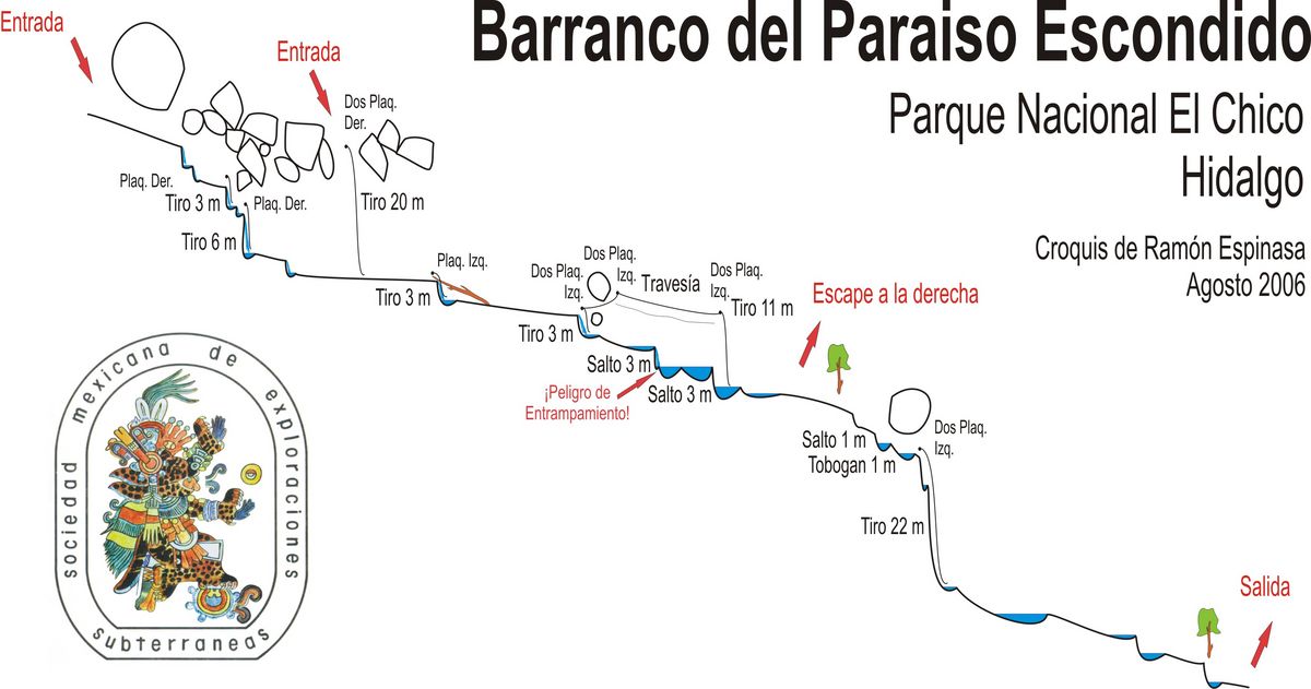
Descenso muy deportivo (en época de lluvias, con agua) que incluye 6 rapeles, el mayor de 22 metros, 3 saltos y 1 tobogán.
During the dry season, there is no need to use the pasamanos ("travesía") and this canyon would better be rated 3B with no R.
Notably, this canyon requires a wetsuit. Especially in winter, the water is frigid. 5mm is uncomfortable and it the bare minimum. Booties, gloves, and even a hood are strongly advised in winter. The is no escape in the first section...
The canyon used to begin with a few small rappels, as seen on the canyon profile. These bolts have been removed. Now, you must enter at the 20 meter rappel, which has two bolts. Someone spray-painted 'Prohibido hacer rapel' (Rappeling prohibited) here. The rappel goes over a sharp edge through a pinch point, so be careful with pulling your rope.


You're now in the canyon. Dark, cold and beautiful. Continue down canyon. There is quickly a small downclimb which true beginners may want to rappel off a bolt on canyon left.


After this there is a swim or two and then another rappel on canyon left. In high water, from this rappel you can do an R-rated traverse on canyon left to another set of bolts. Most likely, however, you're be able to stay in the water, down another small rappel.


There is a short swim, then another rappel into a cold pool. If desired, and you check first, this one can probably be jumped. The canyon then opens for about 10 meters, with an escape on the right.


Continue downstream. Immediately there is a downclimb, and then you can either climb up right to an anchor, or follow the water under a boulder to an anchor. This is the big rappel. The upper anchor makes it about 26 meters, and the lower anchor about 22 meters. You'll rappel along the waterfall and get splashed!


The canyon slots up again after the big rappel, with yet another cold swim, then you walk a few minutes until it ends. Exit on canyon right.
Exit
Al terminar el barranco, seguir la única vereda ascendente, marcada con manchas de pintura verde, de regreso hasta el estacionamiento.
At the obvious opening, with a large camping area on canyon-right, exit and follow the trail up. You want the gradually ascending trail going straight, not the steep trail that goes back up along the canyon.
The trail is easy to follow. There are a few curves and intersections and no signs. Follow the GPS track.

Red tape
Beta sites
 Barranquismo.net : Paraiso Escondido
- Cañonismo.com : Paraíso Escondido
Trip reports and media
Background
La apertura corrió a cargo de miembros del Club Deportivo y Social de Pachuca, en el lejano 1948. Como se trataba de escaladores, armaron varias travesías y tirolesas para evitar mojarse, aunque actualmente se baja por el interior del cauce. Croquis elaborado en 2006, por miembros de la Sociedad Mexicana de Exploraciones Subterráneas