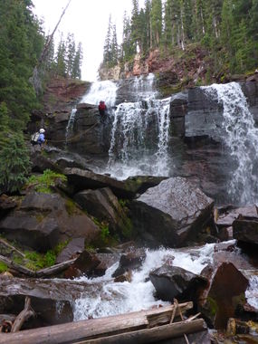
Porcupine Creek
| Rating: | |||||||||||||||||||||||||||||||
|---|---|---|---|---|---|---|---|---|---|---|---|---|---|---|---|---|---|---|---|---|---|---|---|---|---|---|---|---|---|---|---|
| | Raps:5, max ↨100ft
Red Tape:No permit required Shuttle:Optional 10 min Vehicle:High Clearance Rock type:Cutler Sandstone | ||||||||||||||||||||||||||||||
| Location: | |||||||||||||||||||||||||||||||
| Condition Reports: | 27 Jul 2025
"Nice easy canyon with great scenery. Definitely a bit slippery. Just slow things down a little and you should be fine. We replaced the anchor at R1. I |
||||||||||||||||||||||||||||||
| Best season: | July-Sep
|
||||||||||||||||||||||||||||||
| Regions: | |||||||||||||||||||||||||||||||
Introduction[edit]
This waterfall is a confirmed nesting site for the Black Swift, listed as a Species of Special Concern by the U.S. Forest Service and U.S. Fish and Wildlife Service. The swifts migrate from Brazil annually to occupy this site from late May until late September, raising a single chick. The swifts are susceptible to disturbance from human activities near their nests, including noise and movement, direct disturbance or destruction of their nests, and trampling of vegetation. Canyoneering/climbing at this waterfall during the Black Swift nesting season (late May - late September/first frost) is likely to cause direct damage to nests, eggs, and young, and disturb adult swifts enough to cause them to abandon their nest and offspring. Click here for more information on the Black Swift.
Approach[edit]
From Ouray Hot Springs Park, drive south on Highway 550 for 21.5 miles. There is a sign for South Mineral Campground on the right. Make a right and you will be on County Road 7. Drive 4.4 miles to South Mineral Campground and reset your odometer. After South Mineral Campground, high-clearance is required. Drive an additional 1.9 miles on CR7 and there is a small turn-out on the left, room for one car. Park here.
If you get to a Y in the road with a branch leading off to the right and to a mine, you have gone too far. Turn around here and backtrack for about 2/10 mile.
There is a very faint use-trail heading down to the creek. You can see a muddy trail about 2 feet wide leading up the other side. This is the Hardrock 100 Trail. It is barely visible unless you happen to come soon after the race itself. Take this trail. After crossing South Fork you will gain elevation rapidly for about one mile. Thereafter, the trail levels out a bit. Hike another mile or so. You will dip down slightly in elevation before heading up and crossing a small stream. This is not the intended watercourse. Cross the stream and continue on the trail for another 1/4 mile and you will hear the flow of Porcupine Creek ahead and on the left.
Descent[edit]
The drop-in is at the 11,000 foot level. Easier to don wetsuit and gear up trailside. There is a faint use-trail leading down about 100 feet to the watercourse. Make your way down the very slippery watercourse and after about 100 yards is the first rappel.
R1: Log, canyon left, 45ft rappel, short free-hang, After the first rappel is a pretty long downclimb, creeking section to the first big rappel. The creekbed is extremely slippery and is a test of one's will.
R2: Rock Pinch, mid-watercourse, 100ft rappel,
R3: Rock Pinch, mid-watercourse, 60ft rappel, In the middle section is another fairly long down-climb section that features the Hundred Cascades, one of the prettiest cascades anywhere in the San Juans, where hundreds of little cascades pour down.
R4: Tree, canyon left, 90ft rappel
R5: Tree, canyon left, 75ft rappel
Exit[edit]
Follow Porcupine Creek to the confluence with South Fork Mineral Creek. The bottom few hundred feet of Porcupine Creek get choked by thick Willows. You may have to get out of the watercourse and follow any game trails. Once you are within sight of South Fork, stay left and you can down-climb to South Fork right below a stunning cascade. A great place to change out of your wetsuit.
To get back to your car, make your way up the bank on the north side of South Fork and head up the alpine meadow to the dirt road you drove in on. From the road, it is only a 1/2 mile hike up to your car.
