Ranon
| Rating: | |||||||||||||||||||||||||||||||
|---|---|---|---|---|---|---|---|---|---|---|---|---|---|---|---|---|---|---|---|---|---|---|---|---|---|---|---|---|---|---|---|
|
| |||||||||||||||||||||||||||||||
| | Difficulty:3B (v3a2 IV) Raps:5, max ↨66ft
Red Tape:No permit required Shuttle:None Vehicle:Passenger Rock type:Sandstone | ||||||||||||||||||||||||||||||
| Start: | |||||||||||||||||||||||||||||||
| Parking: | |||||||||||||||||||||||||||||||
| Condition Reports: | 13 Jan 2026
"Approach was a bit of a bush bash through lite scrub.. Anchors appeared in fine condition. Ranon brook - ranon (wet side). Last drops into the cla |
||||||||||||||||||||||||||||||
| Best season: | Oct-Apr
|
||||||||||||||||||||||||||||||
| Regions: | |||||||||||||||||||||||||||||||

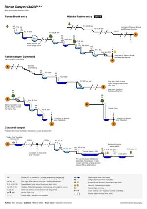
Introduction
Ranon Canyon is an impressive canyon with a series of lovely abseils that enter into the side of the better-known Claustral Canyon, just after the 3 "Blackhole of Calcutta" Claustral abseils. There are two entries into Ranon: Mistake Ravine or Ranon Brook.
- Mistake Ravine entrance and canyon segment is shorter and easier
- Ranon Brook entrance and canyon segment is a little longer but is higher quality and sportier, involving 5 small abseils before reaching the junction with Mistake Ravine
These notes should be read in conjunction with Claustral. Use the GPX from Claustral for the exit track.
Approach
Mistake Ravine (recommended entry for first-timers)
Park in the Claustral "parking lot". On the south side of the road, walk westwards uphill (away from Claustral) to the start of a section of roadside steel "Armco" crash barrier. Using the GPX track from this page: head south-south west to find a spur, and follow the spur down. Avoid the drainage lines. Just above the river, find a gap in the cliffline to enter.
Ranon Brook
If entering via Ranon Brook, the easiest option is to arrange a short car shuffle. Park one vehicle at the Claustral car park (as above) then drive west approximately 2km to a small parking area on your left, just past the 888 high point. If you only have one vehicle you will need to walk this section. Use the GPX route available to download above (hint: "Download KML / GPX links under the map). The foot pad (i.e. obscure path) that used to exist is effectively gone after bushfire regrowth. Following the GPX will help establish the track. Some 100m before entering the river while still on the poorly defined spur, be wary of a hidden cliff line. Keep right to work around it.
Descent
Canyon topo
Photos


Exit
Follow the exit track notes from Claustral.
Red tape
Beta sites
- https://ozultimate.com/canyoning/track_notes/ranon.htm
- https://canyoning.org.au/forum/viewtopic.php?f=24&t=217