Red Canyon (South Fork, Sedona)
| Rating: | |||||||||||||||||||||||||||||||
|---|---|---|---|---|---|---|---|---|---|---|---|---|---|---|---|---|---|---|---|---|---|---|---|---|---|---|---|---|---|---|---|
| | Difficulty:3A IV (v3a1 IV) Raps:4-6
Red Tape: Shuttle:Optional Vehicle:Passenger Rock type:Sandstone | ||||||||||||||||||||||||||||||
| Location: | |||||||||||||||||||||||||||||||
| Condition Reports: | |||||||||||||||||||||||||||||||
| Best season: | Winter Spring Summer Fall
|
||||||||||||||||||||||||||||||
| Regions: | |||||||||||||||||||||||||||||||
Introduction[edit]
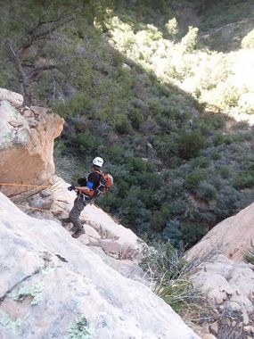
A very scenic hike up to the top of Bear Mountain followed by a very short approach to the head of the drainage where you will have to scramble and bushwack your way down steeply to the first drop.
Approach[edit]
Hike the entire length of Bear Mountain trail to the drop-in point.
Descent[edit]
I would bring a 200ft rope and pull. The start of this drainage is steep. After rappelling the first drop travel lets up a bit but still quite a bit of scrambling down to more drops before reaching the redrock section.
Exit[edit]
Take Red Canyon down and if you can help it take the fence line of the Palatki Ruins Property to the left and around to the road where either your shuttle awaits or do what we did and hitch hike back to the Bear Mountain T/H. We only had one car and easily got picked up so that was nice. We hiked straight through the Ruins property where a ranger was at the entry gate and was very curious as to where we came from with all the gear we had. He was great and we pointed out to him where we descended from as you can see the top of bear and some of the drainage from where we were standing, he was kind of speechless as to what we just did.
Red tape[edit]
Beta sites[edit]
Trip reports and media[edit]
https://www.facebook.com/media/set/?set=a.4322201327800274&type=3
Background[edit]
First Descent by Jay Wisocki and Dinna Marquez
