References:Sardine Creek-20170530224507

From ropewiki.com
Jump to navigation Jump to search
  • Sardine Creek-20170530224507 pic.jpg
  • Location: Sardine Creek
    Reported by: Brad Noren
    Date: 29 May 2017
    Comment: Sardine Creek at Hwy 22 at Extreme level. Doesn't look like much here.
    Waterflow: Extreme
    Very Low Low Moderate-Low Moderate Moderate-High High Very High Extreme
    0% - 40% 40% - 70% 70% - 90% 90% - 110% 110% - 130% 130% - 160% 160% - 200% >200%

    • Very Low: Water flow should not represent any danger (class B = a2).
    • Low: Not as fun, but should be safe even for beginners (class B/C = a3).
    • Moderate-Low: A bit low, still fun but not very challenging (class C1- = a4-).
    • Moderate: Challenging but not dangerous for intermediate canyoneers (class C1 = a4).
    • Moderate-High: A bit high, quite challenging but not too dangerous (class C1+ = a4+).
    • High: High water, only for experienced swift water canyoneers (class C2 = a5).
    • Very High: Dangerously high water, only for expert swift water canyoneers (class C3 = a6).
    • Extreme: Extremely dangerous high water, may be unsafe even for experts (class C4 = a7).

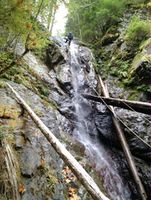
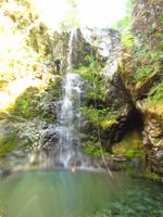
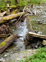
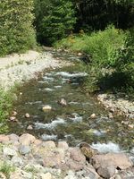
    Historical reference pictures used in Waterflow analysis


    (log in to submit reference picture)

    17 Oct 2015
    Very Low
    21 Aug 2016
    Low
    10 May 2015
    Moderate
    29 May 2017
    Extreme
    29 May 2017
    Extreme
    Sardine Creek-20151018042209 pic.jpg Sardine Creek-20170530043848 pic.jpg Sardine Creek-20150512003229 pic.jpg Sardine Creek-20170530224055 pic.jpg Sardine Creek-20170530224507 pic.jpg