Roaring Creek (Lower)
| Rating: | |||||||||||||||||||||||||||||||
|---|---|---|---|---|---|---|---|---|---|---|---|---|---|---|---|---|---|---|---|---|---|---|---|---|---|---|---|---|---|---|---|
| | Raps:7, max ↨60ft
Red Tape:No permit required Shuttle:None Vehicle:Passenger Rock type:Granite | ||||||||||||||||||||||||||||||
| Start: | |||||||||||||||||||||||||||||||
| Parking: | |||||||||||||||||||||||||||||||
| Condition Reports: | 3 Sep 2025
"Explored the canyon and the mine! The mine is quite cool and there are lots of places to explore. |
||||||||||||||||||||||||||||||
| Best season: | Jul-Sep (avg for this region)
|
||||||||||||||||||||||||||||||
| Regions: | |||||||||||||||||||||||||||||||
Introduction[edit]
A short & beautiful canyon which ends right at Ashlu Creek. An easy approach & mostly easy exit, along with interesting mines to explore makes this an appealing half day canyon suitable for newer canyoneers.
Can be paired with Roaring Creek (Upper) for a much longer day.
Approach[edit]
From the Squamish Valley Road turn onto the Ashlu A600 road and cross the bridge (49.91431, -123.29245).
Drive as far down Ashlu A600 road as possible. From the trailhead at the washed out road (49.93483, -123.39204) hike in 1.9km until reaching Roaring creek (at 49.94312, -123.41191).
Head down the creek, 10 minutes of creek walking should get you to R1.
Descent[edit]
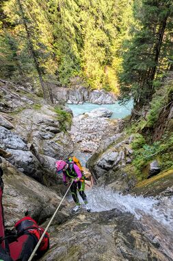
- R1 - 45ft, DCL, 2 bolts
- R2 - 45ft, DCR, 1 bolt
- R3 - 50ft, DCL, 1 bolt (one smashed bolt DCR).
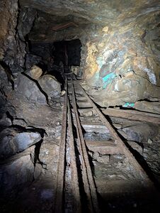
Mine access. Explore the tunnels which wrap around the back of the waterfall, as well as provide an early exit from the canyon.
- R4 - 35ft, DCL, 1 bolt, or down-climb in flow.
Short down-climb, additional bolt for higher flow would be nice.
River comes into sight.
- R5 - 25ft, DCL, 1 bolt on boulder.
- R6 - 50ft, DCL, 1 bolt. Long horizontal pitch down 2 drops to reach R7. Should be replaced with traverse line bolt closer to R7.
- R7 - 60ft, DCL, 2 bolts on face. There is a traverse line bolt on boulder DCC if needed.
Scramble down to the river.
Exit[edit]
From the river, scramble up the DCL slopes and pick your way through the forest up to mine trail. There is one steep cliff section, finding a reliable way through this would be an improvement.
Red tape[edit]
Beta sites[edit]
Trip reports and media[edit]
- Video exploring Ashlu Mine, showing the access road, bridge & mine connecting to the creek.
- Instagram photo of the R1-R3 section, 2019.
Background[edit]
This lower section was originally incorporated in the beta for the upper section. However since it's now been developed all the way to the river, and is different enough in character, it has been separated apart.
Ashlu mine[edit]
The Ashlu mine produced 6500 ounces of gold from 1935 to 1939 when it was shut down for the war. It was not seriously mined again until 1979 when a company came along and opened the mine up again. They built a 3 million dollar mill that is still there today. It only ran for four weeks then the whole operation went bankrupt. They had enlarged the portals to mine with scoop tram loaders. These machines drive on inclines and deliver right to the mill conveyor. It's possible to walk into this mine and get to a big chamber that opens up the raging creek. You can find your way down the levels and exit at one of the original small portals. All of the routes down follow the huge quartz vein. The mine is flooded below this point but you can still see into the depths a ways.
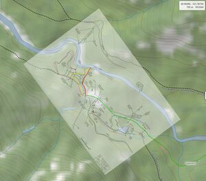
These documents capture a lot of the history of the mine, including maps: https://propertyfile.gov.bc.ca/reports/PF008106.pdf


