Rock Creek (Cowlitz County)
| Rating: | |||||||||||||||||||||||||||||||
|---|---|---|---|---|---|---|---|---|---|---|---|---|---|---|---|---|---|---|---|---|---|---|---|---|---|---|---|---|---|---|---|
| | Raps:2-3, max ↨150ft
Red Tape:No permit required Shuttle:None Vehicle:Passenger | ||||||||||||||||||||||||||||||
| Location: | |||||||||||||||||||||||||||||||
| Condition Reports: | 31 May 2021
"Canyoneers on ice! This is one of the most slippery creeks Ive visited in the Pacific NW. Even canyon-specific footwear comes up short here. Dropp |
||||||||||||||||||||||||||||||
| Best season: | May - July
|
||||||||||||||||||||||||||||||
| Regions: | |||||||||||||||||||||||||||||||
Introduction[edit]
A nice tributary of the Lewis River that flows into the north side of Lake Merwin. Rock has a few short drops and a great slide before reaching the big Rock Creek Falls. The original beta described heading north along the creek and dropping in via a tributary, but the most interesting section is located below the bridge. A better exit route was explored in 2021, although the pay-to-play is a little on the long side.
Approach[edit]
Park in an obvious pullout on the south side of Hwy 503 just east of the bridge over Rock Creek. There's room for several vehicles here.
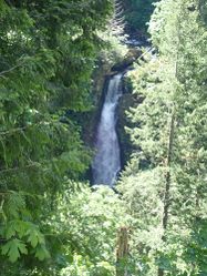
- The checkpoint is the large pullout on the west side of the bridge. There's an opening in the trees where you can look down on Rock Creek Falls.
Some user paths lead southwest down to the creek between R2 and R3, but you'll miss some nice canyon going that way. Instead, cross Hwy 503, and make your way down through the forest to drop in above just north the bridge. Use caution as it's steep and there are some cliff bands occasionally as you drop down through the trees. If lucky, you may find a way to get down without using a rope, but setting a hand line or rappelling may be a safer option.
Descent[edit]
- R1: 10ft.
- R2: 6ft rappel or handline. Just below is a short slide (or jump) into a deep pool.
- The Terraces. Nice area of bedrock with a long low-angle slide into a pool. Possible to repeat it. It appears locals hang out here during the summer. Possible to exit on user trails back to the parking area.
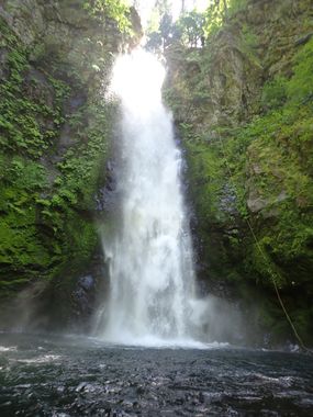
- R3: Rock Creek Falls. 150ft from a big tree DCL. In future, it might be nice to set a bolt station to allow one to run the flow direct. An unlinked anchor station would likely be required per high flow in winter and spring. As this area is visited frequently by locals, it's best to use unobtrusive anchors.
Exit[edit]
Sadly, the big falls is the end of the technical section. Continue downstream all the way to Lake Merwin. The going is slow and slippery. A couple of nice cascades (easily bypassed) signal you're nearing the bottom.
Be aware: the creek reaches the lake at the eastern end of the private community of Woodland Park. You're practically in someone's backyard. Immediately exit the creek DCL (east) and pick up a somewhat overgrown user trail (looked like people were crossing on a log in 2021) leading along the lakeshore. Follow this old trail east until about 45.98965, -122.4675 where a giant patch of blackberries blocks your way. Circle around this bramble thicket and pick up an old, nearly indistinct track leading east into the woods. The track, marked occasionally, with flagging, switchbacks a couple of times, then ascends on a rising traverse up to the powerlines at about 750ft elevation. The track is indistinct at first, but gets better for a good stretch, then gets worse again on nearing the top. At this point, just break off trail and head up wherever is easiest to pop out under the powerlines.
- Alternately, from the blackberry thicket, you might be able to ascend directly up the ridge through mostly open forest. This route has not been explored.
Follow the powerline access track northeast for a couple minutes to Hwy 503 (gated) and walk back along the wide shoulder to your car (~1min). Total distance from the lake back to your car is about 1mi with a gain of ~500ft elevation.
Red tape[edit]
Avoid the private community of Woodland Park and stay on the east side of the creek to exit. This is all on PacifiCorp land and is open to hikers.
Beta sites[edit]
 CanyoneeringNorthwest.com (archive.org) : Rock Creek (Cowlitz County; WA)
 Super Amazing Map : Rock Creek Canyon (Cowlitz County)
- Kayakers running the upper section of Rock Creek early season.
Trip reports and media[edit]
Background[edit]
Further Explorations[edit]
There appears to be another set of waterfalls upstream around 1400' elevation.

