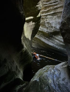
Shamrock Canyon
| Rating: | |||||||||||||||||||||||||||||||
|---|---|---|---|---|---|---|---|---|---|---|---|---|---|---|---|---|---|---|---|---|---|---|---|---|---|---|---|---|---|---|---|
| | Difficulty:3B III (v3a2 III) Raps:8, max ↨100ft
Red Tape:No permit required Shuttle:Optional 20min Vehicle:High Clearance Rock type:Sandstone | ||||||||||||||||||||||||||||||
| Start: | |||||||||||||||||||||||||||||||
| Parking: | |||||||||||||||||||||||||||||||
| Condition Reports: | 31 Aug 2025
"Great conditions today. The recent rains filled up what was potentially a keeper last week. The main keeper was filled to the top as well. The anch |
||||||||||||||||||||||||||||||
| Best season: | Late Spring to Early Autumn;BEST in Jun;Jul;Aug;Sep
|
||||||||||||||||||||||||||||||
| Regions: | |||||||||||||||||||||||||||||||
Introduction[edit]
A scenic, less commonly done WCC canyon with some nice sculpted narrow sections.
The "R" rating is for a deep keeper pothole that could be challenging to escape, but can be avoided while rappelling by carefully clinging to the corner on canyon right prior to entering the pothole.
Approach[edit]
Descent[edit]
R1: 20' anchor tree.
R2: 15’ anchor tree into pool.
R3: 15' tree back RDC or downclimb into pool.
R4: 40' bolt RDC into deep pool.
R5: 50’ bolt RDC or 100’ to continue out of the narrow section and down past potential keeper pothole.
R6: 50' arch in rock high RDC above keeper pothole, with some exposure to get on rappel to avoid keeper pothole. Only required if did 50' on last rap.
R7: 40' tree LDC. This rap can be bypassed on either side.
R8: 70' pinch point center of drainage.
Note: There is a handful of pools that parties may assume is the keeper pothole before actually reaching the real keeper. The keeper lies after rappelling off a precarious (but well placed) bolt on the right side of the canyon. This drop is also indicated by rappelling into a crack/slot perpendicular to the current direction of the canyon that is very pretty and striped from above. After rappelling into the crack there is a pool and then a elevator downclimb into the pool below. THIS is the keeper pothole. To avoid damaging the vegetation, you may access a better anchor by crossing out of the slot on the right side of the canyon ABOVE the elevator downclimb. Here parties will find another precarious anchor off an "arch" that will reduce vegetation impact.
Exit[edit]
Up Clover Creek: Shorter exit. Steep, but quick climb out (using Four Boulders exit).
Down West Clear Creek: Longer exit. Creek walk to the base of Tramway trail. Steep climb out via large southern drainage across canyon from trail.
Further Down West Clear Creek: Longest exit…creek walk along beautiful WCC all the way to Point Trail. Mostly following lightly defined social trails with a few shallow crossings. Hike up steep but good trail to shuttle vehicle (at Point TH). Time estimate: 2-4h. This exit is shown in the YouTube video below.
Red tape[edit]
Beta sites[edit]
 Super Amazing Map : Shamrock Canyon
 CanyonChronicles.com : Shamrock Canyon
 HikeArizona.com : Shamrock Canyon
 Arizona Technical Canyoneering Book by Todd Martin : Shamrock Canyon
Trip reports and media[edit]
- https://www.facebook.com/pat.winstanley.7/media_set?set=a.556172634441438.1073741852.100001461198708&type=3
 Candition.com :
