Shaver Cut (Upper Stevenson Creek)
| Rating: | |||||||||||||||||||||||||||||||
|---|---|---|---|---|---|---|---|---|---|---|---|---|---|---|---|---|---|---|---|---|---|---|---|---|---|---|---|---|---|---|---|
| | Raps:4-6, max ↨120ft
Red Tape:No permit required Shuttle:Optional 1hr Vehicle:Passenger Rock type:Granite | ||||||||||||||||||||||||||||||
| Start: | |||||||||||||||||||||||||||||||
| Parking: | |||||||||||||||||||||||||||||||
| Shuttle: | |||||||||||||||||||||||||||||||
| Condition Reports: | 14 Sep 2022
"From SCE:. SCE will be making releases to Stevenson Creek again starting tomorrow, 9/14. These releases may continue to the end of September but s |
||||||||||||||||||||||||||||||
| Best season: | June to December, BEST July to October
|
||||||||||||||||||||||||||||||
| Regions: | |||||||||||||||||||||||||||||||
Introduction[edit]
A short swift water canyon right next to the road. The canyon is only a hundred yards long or so if done as a loop, but it is challenging as it is a tricky V slot with very fast water. The flow is usually 5-7cfs. Online flow information is available.
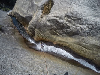
The creek has cut a V shaped sluice with several small waterfalls between the main dome and a steep granite slab on the left. Parts of the sluice can be bridged, but the sides are so slippery that it is impossible to stay out the water. When in the water it is very powerful and difficult to deal with.
Flow information is available from Southern Cal Edison at: [1] Stevenson Creek Below Shaver Lake
The canyon can optionally completed to the road below, making it probably the best fun for the effort in the area. Short, nearly level approach and exit bookend a really fun pothole slot section with really pushy water and a couple jumps and short low-angle slides later in the canyon, broken up by creek sections which are level, mostly open, completely lacking in poison oak (seriously, didn't see ANY), and feature blackberries at the right time of year.
Approach[edit]
Take Highway 168 from Fresno to Shaver Lake. Going around the lake, the road drops down to cross Stevenson Creek below Shaver Dam. There is a very large turnout parking area just before the road crosses the creek. An obvious granite dome rises above the creek. Short trails lead from the parking area to the dome. The left hand trail follows the creek then crosses at a small gauging weir. The trail leads to ledges at the base of the dome and climbing routes leading up from there. The creek has cut a V shaped sluice with several small waterfalls between the main dome and a steep granite slab on the left.
Descent[edit]
R1: 60', fast moving water be careful to not be swept off the edge of R2
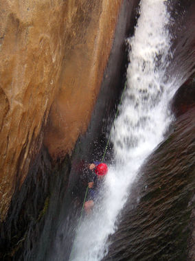
R2: 70', rappel to a redirection and use the redirection to stay out of the waterfall. The flow can have the effect of pulling you in towards the crack, and making it difficult to escape if one were to get stuck in the crack. This crack has been the site of a canyoneering fatality in 2014, after the canyoneer failed to reach the newer redirect, swung into the crack, was forced upside down, and quickly drowned. There may have been a foot entrapment. It is almost impossible to see or hear what is going on from the top or bottom. Rescue is improbable.
As of September 2016 a second bolt has been added to the redirect. This way the first party member down can set up a traverse for the rest of the group. This avoids an intimidating traversing rappel for the rest of the group members, and provides more rescue options if someone gets stuck in the crack. The rappel from here still puts you into the full force of the waterfall, and is quite intense, but gives you a better angle. Trying to avoid the waterflow altogether could result in a dangerous pendulum into the crack.
The bent-open hook (held on by a rusted quick link) is still there as of September 2016, please consider bringing a wrench to remove the unsafe hardware.
R3: 15’ down a boulder (or through a crack to the right of it). This could also be downclimbed.
R4 (optional): approx. 100’. A final open waterfall could be rappelled to add a little to the canyon.
Option: exit here for a loop back to your car, OR:
Continue down canyon from here to a narrow slot section with several potholes in a short series and pushy water. A tree was rigged to drop halfway into it, which we completed on rope to above the last pothole. We slid the last pothole. Hydraulics were notable but all potholes were escapable in ~6.5 cfs.
Below this there are a few good short slides, a couple jumps (check potholes!), and, if you're lucky, some tasty blackberries to get you through the longest creek walking section.
Exit[edit]
(The current map on ropewiki shows an exit to the left (south) at the bottom of the canyon. We tried this, and it was fairly unpleasant. The exit described below seems like a better idea (-Rick I):
The canyon opens up completely at the base of the dome. Scramble and hike to the right (east) around the base and back up to the road. Alternatively, one can do very exposed climbing up the backside of the dome through some very interesting terrain. From the top of the dome, downclimb the south side of the dome through a short tunnel and sloping ramps.
Red tape[edit]
Canyon is inside burn area of 2020 Creek Fire. Expect impacts to road, canyon, and surrounding area. Before going, review any relevant Sierra NF alerts and closure orders. See also Sierra NF road conditions.
Beta sites[edit]
Trip reports and media[edit]
- Trip Report from First Descent
- Article on Fatal Accident in 2014
- Bogley Discussion on Accident in 2014
Background[edit]
First descent by Paul Martzen and Tim Schiller in August 2005.
Despite being a short accessible canyon, this canyon is known to be dangerous, particularly due to the second waterfall (R2). There is a bolt placed out on the wall to redirect the rappel away from where the falls drop into a narrow crack with constrictions and entrapment features, but even with proper use (either as a redirect or as a rebelay), people have reported near misses on this feature, either by getting stuck behind the curtain in the local concavity, or by sticking their foot into a deep "ankle eating crack" towards the bottom, whose danger is compounded by a chockstone.
On July 5, 2014, Luis Ortiz drowned after getting stuck in this feature. During the body recovery, Edison shut down the flow, so that rescuers could safely access the slot.
From the initial report, "The Canyon: Shaver Cut. A rappel had a deviation anchor to avoid a waterfall that you could potentially get stuck in. The options for the deviation were a biner, rapide, and an old rusty hook. A member of our group used the hook to deviate his rappel. He then slipped, shock loaded the hook, the hook gave out and bent, and he pendulumed into the waterfall and got stuck, wedged between rocks. We tried to help from above and below to no avail. He drowned."

