Sheep Canyon (South Cascades)
| Rating: | |||||||||||||||||||||||||||||||
|---|---|---|---|---|---|---|---|---|---|---|---|---|---|---|---|---|---|---|---|---|---|---|---|---|---|---|---|---|---|---|---|
| | Raps:3-5, max ↨110ft
Red Tape:No permit required Shuttle:None Vehicle:Passenger | ||||||||||||||||||||||||||||||
| Start: | |||||||||||||||||||||||||||||||
| Parking: | |||||||||||||||||||||||||||||||
| Condition Reports: | 27 Aug 2022
"No other anchors were found, so this was probably a first descent. Rappels are nice, but the creek is a little overgrown which was surprising given it |
||||||||||||||||||||||||||||||
| Best season: | Jul-Aug
|
||||||||||||||||||||||||||||||
| Regions: | |||||||||||||||||||||||||||||||
Introduction[edit]
Baaaah! A tributary of the Toutle River that drains a small section of the western slopes of Mt. St. Helens. The canyon begins just below the bridge where the Toutle Trail crosses the creek. The area was scoured out by lahars (super-heated mudflows) in the 1980 eruption. Sheep Canyon has a moderate pay-to-play per the hike in and out. Despite the distance, the hiking is relatively mellow. Keep an eye out for elk in the area.
- Note that this creek drains an alpine area, so water levels may be significantly higher than others in the area on hot days. It's probably best to run in late summer.
Approach[edit]
From the Blue Lake trailhead, hike north on the Toutle Trail for ~3mi (800ft gain) to the bridge over Sheep Canyon. The trail crosses a low pass above Blue Lake, but the approach is relatively easy.
- There are numerous dispersed camping sites at and en route to the trailhead.
Descent[edit]
- R1: 15ft from small tree DCR.
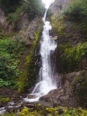
- R2: Sheep Canyon Falls - 110ft from tree high DCL. Beware loose rock.
- R3: 90ft from cairn anchor DCL. It is likely that the cairn will need to be rebuilt every year. (Or use another anchor.)
Walk downstream for 0.4mi. If the flow is high, it's possible to escape up the forested slopes DCL.
- R4: ~85ft done in two stages. The creek narrows up on the approach with a couple of minor drops before the main one. Stay DCR on a small ridge.
- R4a: Rappel 20ft from a tree down a loose gravelly slope to another tree (anchor for R4b) on the brink of the falls DCR. May be best to treat this as a rebelay.
- R4b: Rappel 65ft (?) into the narrows alongside the flow.
- R5: The Sheep Chute - ~90ft (?). The creek plunges down two consecutive chutes and can kick off a huge rooster-tail when flow on the creek is high. Stay out of the flow by rappelling a line DCR down along the edge of the water.
You can also bypass R4 and R5 by following elk trails along the rim DCR and rappelling back in below R5.
Exit[edit]
After the final waterfall, head downstream a short distance before crossing the creek one final time, and follow an elk trail up onto a bench above the creek. This is a good place to change out of wetsuits. From here, follow elk trails (numerous and divergent) south up the slopes about 500ft to the old Sheep Canyon trailhead. (If the road is ever repaired, one could park here, turning Sheep Canyon into a canyon one could run in a few hours.) From here, turn left/east and follow the old Sheep Canyon Trail about 0.5mi back to the original junction near the bridge. There are some nice old-growth trees along the way. Hike back the way you came to the Blue Lake trailhead. (Make sure you take the correct trail on the way back; it's easy to get confused. If you cross a creek and pass a large campsite, you are going the wrong way.)
Red tape[edit]
None.
Beta sites[edit]
Trip reports and media[edit]
Background[edit]
Sheep Canyon was first descended in August 2022 by Kevin Clark, Wade Hewitt, Ashley Driscoll, and Clint Clow.
