Spring Canyon (Lytle Creek Area)
| Rating: | ||||
|---|---|---|---|---|
| | Difficulty:3A II (v3a1 II) Raps:2, max ↨200ft
Red Tape:No permit required Shuttle: Vehicle:4WD | |||
| Location: | ||||
| Condition Reports: | 9 Jul 2023
"Time reflects running both Spring and Bonita. Bottom-up approach had some exposed climbing but there are probably easier ways of doing it. Existing an |
|||
| Best season: | ||||
| Regions: | ||||
Introduction[edit]
The route described here is as a loop, and while it takes the same length of time it bypasses a long featureless upper portion and a lengthy 4x4 shuttle. Brennen's route is on the map for reference. This route climbs a up steep, overgrown, and loose ridge but rewards with access to the only 2 rappels i n the canyon. This canyon is worth the effort while the flow is good.
Approach[edit]
Follow the same path upstream of the South Fork as if headed to Bonita Falls. You keep hiking past it until you comes across spring on your left. Make your way upstream for about 15 min and start looking on the right for a way up the ridge. The exact route will vary, as several columns were loose with little vegetation. Once at the ridge, stay on the east side of it finding the path of least resistance. You'll be able to hear water eventually, and catch glimpses of the falls so it is easy to plan ahead when to start heading down. The ridge is overgrown and one must be careful to negotiate slow and purposeful.
Descent[edit]
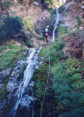
Once is the canyon, you are able to see both waterfalls and what essentially is the end of the technical section. It is very short but spectacular. First rappel is about 80' and anchored from a bush RDC. The second rappel is two stages but can be done with 200' of rope. Anchors are abundance with trees on both sides of the canyon.
Exit[edit]
After the second rappel, you can remove your harness and just hike back to your vehicle the same way, about 45min.
Red tape[edit]
There is a gate blocking access to the fire road to get to the head of the canyon which may or may not be open. It appears it can be closed at any time due to rain, snow or fire danger. You can call the Lytle Creek Ranger Station at 909-382-2851 and check the status of the gate.
Beta sites[edit]
 Chris Brennen's Adventure Hikes (St Gabriels) : Spring Canyon
 Super Amazing Map : Spring Canyon
Trip reports and media[edit]
Screencap Summary Gallery by Christian Lupercio
Background[edit]
First canyoneering descent in Sep.2003 by Bill Bees, Chris Jain, Dave Goldstein and Chris Brennen.
