Spruce Creek
| Rating: | |||||||||||||||||||||||||||||||
|---|---|---|---|---|---|---|---|---|---|---|---|---|---|---|---|---|---|---|---|---|---|---|---|---|---|---|---|---|---|---|---|
|
| |||||||||||||||||||||||||||||||
| | Raps:6, max ↨100ft
Red Tape:No permit required Shuttle:None Vehicle:4WD - High Clearance | ||||||||||||||||||||||||||||||
| Location: | |||||||||||||||||||||||||||||||
| Condition Reports: | 20 Aug 2017
"Decent took around 3.5 hours. We accidentally downclimbed two of the rappels before realizing that the canyon was just that open. Any of the rappels c |
||||||||||||||||||||||||||||||
| Best season: | Jun-Sep
|
||||||||||||||||||||||||||||||
| Regions: | |||||||||||||||||||||||||||||||

Introduction
Spruce Creek is a good introductory aquatic canyon within a day trip from the Denver area. The narrows are not deep or committing. Exits and anchor options are abundant. Many of the rappels have small steps and tiers, which make for good practice negotiating edges in flowing water. This could be a good low-commitment canyon to practice new techniques and get out with new partners. Spruce Creek is not a destination canyon, but some fun can be had in the right water levels.
The final rappel is Continental Falls, a short falls which is a popular hiking destination for Breckenridge hikers/tourists.
Old mining equipment can still be found in parts of the canyon hikers can't access or see from the rim.
Approach
Driving: Head South on Highway 9 from Breckenridge, Colorado. Drive nearly 2 miles to Spruce Creek Road on the right. Turn left at the next T intersection, immediately after the turn off from Hwy 9.
- The lower trailhead is in 0.9 miles from the T intersection. Park here with low clearance vehicles and begin hiking the trail on the East side of the parking lot, which adds 3-4 miles to the round trip.
- Park at the upper trailhead with a high clearance or 4wd vehicle. Continue further up Spruce Creek Road. In 0.3 miles, go left at a Y intersection and park as far as possible along the road.
On foot from the upper trailhead: Pick up the trail and pass at the old dam. When crossing the creek, assess the water level of Spruce Creek.
Hiking: When the trail reaches the Continental Falls Trail, go left to continue uphill to Lower Mohawk Lake. Once at the lake, suit up and head down the pour off carefully negotiating the willows.


Descent
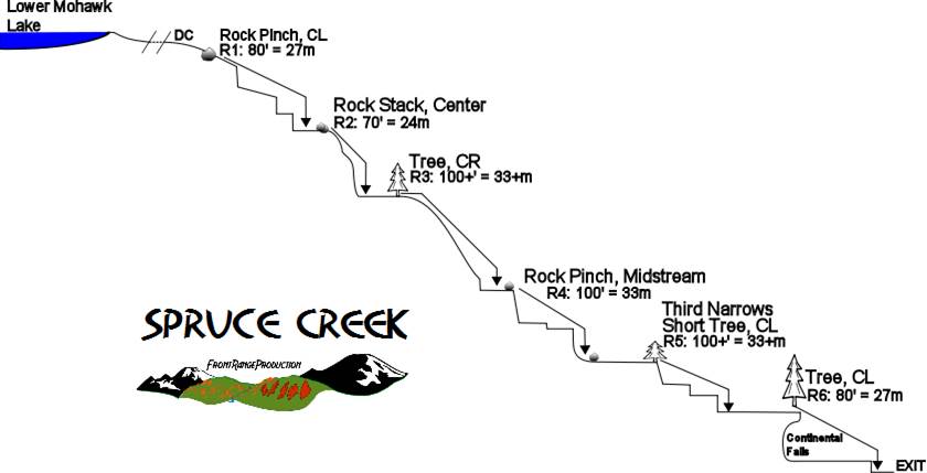


R1: 80' First Narrows from rock pinches on either Canyon Right or Canyon Left
R2: 70' from a rock stack in Canyon Center


R3: 120' from a tree on Canyon Right
R4: 100' from a rock pinch in Canyon Center


R5: 120' Second Narrows from a tree on Canyon Left
R6: 80' rope for 20' Continental Falls and following short falls/ Third Narrows from a tree on Canyon Right


Exit
Hike out after the last waterfall by means of the overlook spur trail, back to the main trail and back to the car.
Red tape
Beta sites
Trip reports and media
Background
The first canyoning descent of Spruce Creek was on Sunday, October 7, 2001, less than a month after 9/11. This was also the day that the US and UK began Operation Enduring Freedom, and was the first day of combat operations in Afghanistan in order to remove the Taliban and bring Osama bin Laden to justice. Several tourists asked the canyoners if they were, in fact, training for Afghanistan during their descent.