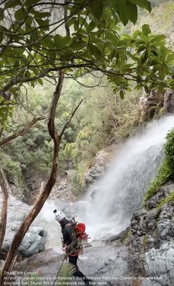
Thurat Rift
| Rating: | |||||||||||||||||||||||||||||||
|---|---|---|---|---|---|---|---|---|---|---|---|---|---|---|---|---|---|---|---|---|---|---|---|---|---|---|---|---|---|---|---|
|
| |||||||||||||||||||||||||||||||
| | Difficulty:4B (v4a2 IV) Raps:15, max ↨203ft
Red Tape:No permit required Shuttle:Required 10km Vehicle:Passenger Rock type:Quartzite | ||||||||||||||||||||||||||||||
| Start: | |||||||||||||||||||||||||||||||
| Parking: | |||||||||||||||||||||||||||||||
| Shuttle: | |||||||||||||||||||||||||||||||
| Condition Reports: | |||||||||||||||||||||||||||||||
| Best season: | Nov-Mar
|
||||||||||||||||||||||||||||||
| Regions: | |||||||||||||||||||||||||||||||

Introduction
Thurat Rift is a magnificent wilderness trip, following a fairly even descent down Thurat Rift Creek. It is the longest of the Kanangra canyons; parties need to move efficiently.
In summer on a warm day wetsuits are not needed.
The canyon is usually done as an overnight, with campsites as described below. A fast, efficient, and fit party can do the entire canyon and exit in a day. From Mount Barry (see exit) it is quite possible to walk out in the dark on the good path (but see the warning below).
The anchors in the canyon are set for interaction with the flow. The canyon is not suitable for a winter trip.
Water levels
Use the river gauge 212260 Kowmung River @ Cedar Ford to judge water levels in Kanangra. Refer to the Kanangra Main entry for indications of range. However, Thurat Rift is not often descended and as of 2023 there isn't sufficient history to map the Cedar Ford flows to Thurat Rift conditions.
- <250 ML/d: Low water, A2. No aquatic features. Abseiling in low to moderate flows.
Note: The Kowmung gauge does not measure the volume of water in Thurat Rift directly. It is a "proxy gauge" and has a catchment of 733 km² while the catchment above Thurat Rift is much smaller at approximately 2.7 km². To compare, the Kanangra Main catchment is 10 km².
The following route description requires a car shuffle; it uses the "easiest" possible exit from the canyon end.
Approach
Download the gpx/kml from the map above. Load onto your preferred navigation device.
Leave a car/bicycle/running shoes at the Kanangra Walls parking lot. Park at the King Pin firetrail on the Kanangra Walls road.
Follow the King Pin firetrail to Mount Thurat. Follow the ridge along Thurat Tops to the intersection of Thurat Ridge and Burra Gunama Ridge. Follow Burra Gunama Ridge then drop directly south into the creek, as per GPX. Walk about 150m downstream through beautiful riverine forest to the first waterfall.
Descent
| # | Anchor | M | Notes |
|---|---|---|---|
| 1 | RL, tree | 47 | Down side waterfall. |
| 2 | RL, tree | 20 | Down middle waterfall |
| 3 | RR, bolts | 20 | Bolts well up right. |
| 4 | RR, bolts | 20 | Double drop |
| 5 | RR, bolts | 10 | |
| 6 | RL, bolts | 15 | Down cascades |
| 500m creek walk | |||
| 7 | RR, bolts | 15 | Bolts over edge on right. Might need access line. |
| 8 | RR, bolts | 30 | Bolts over edge on right. Use P6 abseil line for access. |
| 9 | RR, tree | 62 | Note: the intermediate 40m anchor RL is washed away |
| 10 | RL, bolts | 55 | Bolts far left over edge. Might need access line. |
| 11 | RL, bolts | 40 | Nice waterfall. |
| 12 | RL, bolts | 10 | |
| 13 | RL, bolts | 10 | |
| 14 | RL, bolts | 15 | Or walk off side after 8m |
| 15 | RL, bolts | 55 | Bolts over edge. Might need access line. Stay on rope all the way to the bottom. |
| Creek walk | |||
| 16 | RR, rope | 10 | |
| 17 | RR, rope | 5 | |
| Long creek walk. | |||
| 18 | RL, tape | 20 | Optional. In low water can traverse RR. Can climb around in trees up RR |
Exit
After the last abseil, walk down to Kanangra Creek, then strike upstream (westwards).
There is a campsite between the last two abseils at -33.949301,150.1318701 that can accommodate 6-8 people. There are multiple unmade campsites in Kanangra Creek shortly after joining the creek and striking upstream.
Ascend the spur leading to Mt Berry. Do not "shortcut" onto the spur too early, as there is a cliffline on the eastern flank; note how the GPX track ascends. Attempt to stay on the spur as much as possible. As at summer 23/24 the ascent is bushed, but passable. From the ridge summit, return to Kanangra Walls on the well-worn path. Follow the path closely on your OSM mapping app.
Warning: if crossing Kanangra Walls at night, exercise extreme caution and perfect map reading, following the path exactly as per OSM. Canyoners have walked off the edge in the dark.
Red tape
None.
Beta sites
Trip reports and media
Richard Pattison, Thurat Rift movie. Noting that many of the anchors have since been repositioned into the flow, and are very different to this video.