Tiny Santa Anita Canyon
| Rating: | ||||||||
|---|---|---|---|---|---|---|---|---|
| | Difficulty:3A III (v3a1 III) Raps:max ↨140ft
Red Tape:No permit required Shuttle:Required 10 min Vehicle:Passenger Rock type:Granite | |||||||
| Location: | ||||||||
| Condition Reports: | 12 Jan 2020
"Cesar: We had to do a lot of clearing all the way down the canyon as it was evident by the brush and webbing that the canyon had not been visited in |
|||||||
| Best season: | ||||||||
| Regions: | ||||||||
Introduction[edit]
TSA (Tiny Santa Anita) is a normally dry tributary to LSA (Little Santa Anita) dropping some 2000 vertical feet from the ridge on the East side of LSA.
Approach[edit]
Park one vehicle at Mt Wilson Park (LSA parking) and take your shuttle vehicle to Chantry Flat. Chantry Flat parking fills quickly in the morning, however there is private parking ($20 on weekends) that opens at 8AM. The Forest Service parking is subject to the Adventure Pass, or Federal Land Pass. Hike up the gated road to the Helipad (elevation 2440) and at the South end of the building is the ridge trail that climbs steeply up the ridge back to the road way above. Head South (still uphill for a bit) to the South end transmitter building (3230 feet elevation) on the South West corner of the fence around the building, head into the brush through a small gap and follow the cut path down into the very top of the canyon.
Descent[edit]
Follow the top of the canyon (ravine) down 1000 vertical feet, most always in the drainage center, but sometimes on right or left around dead fall. Most of this 1000 feet is steep dirt, fine gravel, and or a bit of scree. There are a few easy and short down-climbs. There is no poison oak in the higher parts, just a couple brushes at a side drainage DCL and a few vines at the narrow S bend of the canyon. At about 2200 feet elevation you come to
- R1 ~140 feet (2 stage 50, then 100 feet) anchored from a bush DCL with old blue webbing.
- R2 ~50 feet is well below R1 anchored with webbing off stacked boulders DCL.
- R3 and R4, short low angle rappels that can be ghosted off of nearby bushes.
- R5 ~140 feet webbing anchor off a bush up high DCR and goes down a long steep slab with a deep chimney DCL.
- R6 ~40 feet webbing anchor off a boulder DCL.
- R7 ~100 feet webbing anchor off a big rock DCR, over a slab, into a wide chimney DCL (2 stage).
- Hike down past a fig tree against the right wall and a few poison oak vines on the left wall.
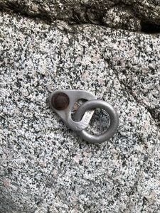
- R8 ~50 feet webbing off a bush 10 feet up DCR, or a single old bolt with ring hanger low DCL.
Hike 150 feet horizontally with a short down-climb and you are in LSA
Exit[edit]
Follow LSA down stream to the catch basin, hike up the road DCR, climb over the spiked fence on the right side against the sloping concrete. Be careful not to get your clothes, harness, or backpack caught on the spikes; or worse impaled! Hike down the neighborhood street back to Mt Wilson Park (LSA parking).
Red tape[edit]
Parking on the Forest Service property at Chantry Flats requires an Adventure Pass
Beta sites[edit]
Background[edit]
Ask Anderson since his link is broken. All I can say is we found very old webbing anchors and one very old bolt Jan 2020:

