Titanium Chalupa
| Rating: | |||||||||||||||||||||||||||||||
|---|---|---|---|---|---|---|---|---|---|---|---|---|---|---|---|---|---|---|---|---|---|---|---|---|---|---|---|---|---|---|---|
| | Difficulty:3A IV (v3a1 IV) Raps:7, max ↨300ft
Red Tape: Shuttle:None Vehicle:4WD - High Clearance Rock type:Granite | ||||||||||||||||||||||||||||||
| Location: | |||||||||||||||||||||||||||||||
| Condition Reports: | 29 Dec 2019
"First Descent. We were surprised by the pothole full of water, as well as the last two rappels which came after a long wash walk segment. We didnt se |
||||||||||||||||||||||||||||||
| Best season: | Nov-Apr
|
||||||||||||||||||||||||||||||
| Regions: | |||||||||||||||||||||||||||||||
Introduction[edit]
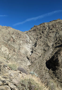
Titanium Chalupa is a unique full-day canyon in the eastern outskirts of the Santa Rosa Wilderness. A polished granite hallway leads to a prominent, broken headwall, followed by several smaller rappels. The section of long rappels near the top affords views of nearby Plutonium Nopales Canyon. A short walk through the wash below features some interesting exposed bedrock and two more rappels before the confluence with (nontechnical) Agua Alta Canyon.
Approach[edit]
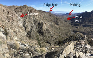
A high-clearance 4x4 vehicle is all but mandatory to reach the closest legal parking area for this canyon. The 'gatekeeper' obstacle is a steep ditch entry and exit at the start of the 4x4 approach track. From Avenue 66, turn left onto Van Buren and head south on a dirt road between plots of date palms until you reach an intersection at approximately 33.55497, -116.198465. Turn right on the dirt road, pass two locked gates, and enter the wash via the aforementioned ditch crossing. Follow a faint jeep trail 4.6 miles through the wash towards Martinez Canyon and park just before the signed wilderness boundary at 33.51410, -116.23190.
The approach hike begins gradually but should not be underestimated, especially in hot weather. Expect full sun exposure on the approach, and significant, occasionally exposed, boulder hopping for the final 600 vertical feet of elevation gain. On a clear day, beautiful views of the Salton Sea to the east reward your efforts.
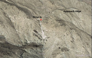
From the parking area, head northwest along the remains of a 4x4 track. At approximately 33.52395, -116.26356, the tire tracks give way to washouts. Continue up the wash for approximately a quarter of a mile, then bear north up a small drainage until you reach a saddle at approximately 33.53062, -116.27751. Here the ascent begins in earnest. Choose the path of least resistance up the steep slope to the northwest, passing a false summit, until you gain the ridge. Follow the ridge to its confluence with the obvious drainage that parallels it to the north, and enter the Titanium Chalupa drainage across the small saddle immediately to the west.
The upper portion of the drainage above the drop-in does not appear to hold anything of technical interest.
Descent[edit]
- R1 80' from a slung boulder canyon left. It is possible to downclimb this rappel over broken rock to the far right of the drop.
- R2 100' from dual slung boulders canyon center to a large, obvious ledge.
- R3 300' from deadman anchor in the center of the R2 landing ledge. Opportunities likely exist for intermediate anchors at a second large ledge approximately 200' below the R3 anchor, but none were constructed on the first descent.
- R4 40' from deadman anchor canyon center into a hallway. If it has rained recently, a shallow pothole at the bottom holds just enough water to soak any excess rope. This rappel joins into the Plutonium Nopales drainage.
- R5 100' from a knot chock DCR from the large boulder captured behind the pothole.
The remaining two rappels lie approximately three-quarters of a mile down canyon from the base of R5, just before the confluence with the main Agua Alta wash.
- R6 40' from a slung boulder canyon center
- R7 35' from a slung boulder canyon center into the main wash.
All rappel lengths are approximate.
Exit[edit]
Follow the main Agua Alta wash southeast until it rejoins the old jeep trail used on the approach.
Red tape[edit]
This canyon lies within the Santa Rosa Wilderness. Check current restrictions before you go. Vehicular travel is not permitted beyond signed wilderness boundaries.
Beta sites[edit]
Trip reports and media[edit]
Background[edit]
The Chalupa is not visible from the approach road or hike and was first spotted on Google Earth due to its prominent headwall. First descent by Morgan Diefenbach and David Angel on December 29, 2019.


