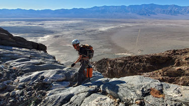
Tombstone Canyon (Black Mountains)
| Rating: | |||||||||||||||||||||||||||||||
|---|---|---|---|---|---|---|---|---|---|---|---|---|---|---|---|---|---|---|---|---|---|---|---|---|---|---|---|---|---|---|---|
| | Difficulty:3A IV (v3a1 IV) Raps:8, max ↨115ft
Red Tape:No permit required Shuttle:None Vehicle:Passenger | ||||||||||||||||||||||||||||||
| Start: | |||||||||||||||||||||||||||||||
| Parking: | |||||||||||||||||||||||||||||||
| Condition Reports: | |||||||||||||||||||||||||||||||
| Best season: | Nov-Mar
|
||||||||||||||||||||||||||||||
| Regions: | |||||||||||||||||||||||||||||||
Introduction[edit]
NOTE: This makes the 2nd canyon in Death Valley named "Tombstone Canyon" . The First one was completed in the Cottonwood Mountains on February 2, 2013. That one completed by Scott Swaney, Rick Kent, Verdi Tanrierdi, Tina Tretina & Jared Plummer. This second canyon named "Tombstone Canyon" was completed December 19, 2020 by Rick Kent & team. Just to attempt to clear up any confusion as to the names being the same inside Death Valley National Park.
Approach[edit]
From the junction of Highway 190 and Badwater Road, drive about 27.6 miles south on Badwater Road. Note, this is about 11.0 miles south of the Badwater parking area. There is a long, straight stretch of road on the south side of Copper Canyon’s enormous alluvial fan. Park at the east end of this straight stretch, where the road turns at the foot of the mountain.
Hike north from the parking spot, staying in the alluvial paths just left of the more rocky alluvial fan. After about .6 mile, continue hiking on easy terrain to the northeast, and then north up into a wash. About .1 mile into the wash, look for a dryfall on the right.
About 50 feet past this dryfall, on the same (right) side of the wash, ascend the steep slope. Avoid the tempting smooth terrain on the left (north). Stay to the right and go up the more steppy stuff. About 50 feet up, there is a rock outcrop, and you will want to head for the left side of that. Directly above the rock outcrop, find your way into a very small gully. As soon as the terrain levels out a bit (about 120 feet up), exit to the right and enter a significant and obvious drainage.
Continue up this drainage, bypassing left or right or climbing each dryfall as it is encountered. After about .3 to .4 mile, fork right, into what appears to be a side drainage. Another few hundred feet after that, fork right again. From there, continue up the drainages, forking to the right every time there is a choice, until it levels out at the top, at a minor saddle, just below elevation 1000 feet. From here, the canyon in front of you is High Noon Canyon.
From the level area, angle to the left (northeast) into High Noon Canyon. Ascend directly up the slope on the opposite side. After about 350 feet of ascent, the route will level out. Angle down to the right (south) to cross over a shallow drainage and back up onto the ridge on the other side. Continue east-southeast up the ridge to around elevation 2600 feet.
The canyon to the right is the upper part of Six Shooter North. Angle to the right (south) to traverse into the canyon, winding up on the canyon floor at around the same elevation, 2600 feet. From here, there is a reasonable (for DV) route up the other side of the canyon. Ascend to the ridge on the south side.
Turn left (south-southeast) and go up the broad ridge about 200 vertical feet. From here, around elevation 2950 feet, angle to the right (south) and pass above the top of a shallow gully, which is the top of Six Shooter South.
Continue south over another broad ridge, across a shallow gully, and then to the next ridge. Continue down into a deeper gully. This is Trigger Finger Canyon.
Continue directly across Trigger Finger and ascend the opposite slope a few-hundred vertical feet, up and over a relatively flat area, and then down into the next drainage. This shallow gully is the top of Tombstone Canyon.
Descent[edit]
The upper half (about 1500 feet of descent) of this canyon is a trip through rubble hell. I’ve done a couple-hundred Death Valley canyons, and the upper part of this one is in the top 5 worst. Hopefully, you’re the kind of person who reads ahead and saw this description before deciding to do this canyon!
Rap 1: 70ft?
Rap 2: 65ft?
Rap 3: 115ft?
Rap 4: 85ft?
Rap 5: 50ft?
Rap 6: 15ft?
Rap 7: 35ft?
Rap 8: 60ft?
Rappel length is rope length, not drop height. All rappel lengths are approximate. Some are only estimated, not actually measured. Numbers provided as a rough guide only. Be aware of your surroundings and do not blindly follow any canyoneering info. Max rap length of 115 feet is an approximation.
Exit[edit]
About .3 mile of downhill on alluvial fan, and then another .3 mile on the road.
Red tape[edit]
Beta sites[edit]
Trip reports and media[edit]
Background[edit]
Rick Kent discovered the canyon and came up with the name in 2018.
First descent: 19 December 2020. Mike Cressman, Mark Duttweiler, Justin Ibershoff, Rick Kent, Ali Miller, Sarah Perlotto, Josh Rodriguez, Tim Seavy, Tina Tretina, Abby Wines. (Alphabetical order.)
