Tunki
| Rating: | ||||||||||||||||
|---|---|---|---|---|---|---|---|---|---|---|---|---|---|---|---|---|
| | Raps:22, max ↨197ft
Red Tape:No permit required Shuttle:None Vehicle:Passenger Rock type:Shale | |||||||||||||||
| Location: | ||||||||||||||||
| Condition Reports: | ||||||||||||||||
| Best season: | ||||||||||||||||
| Regions: | ||||||||||||||||
Introduction[edit]
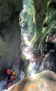
Tunki is one of the most technical canyons in the area, simply from having more than 20 rappels up to nearly 60 meters in height. The canyon is quite beautiful and descends down through a narrow gorge with high walls. It ultimately joins the Ch'alla canyon drainage which you can repeat part of, or exit back out onto the approach trail from the morning.
Update 2023: This canyon has not been descended since 2019 (we didn't do it during 2023 either), so be fully prepared to replace a lot of the anchors if you descend this.
Approach[edit]
Drive to the town of Ch'alla along a paved road. Just after the bridge that you pass when entering the town, go to the left and leave a vehicle. The bridge spans the Ch'alla canyon, which is a separate descent but shares the final part with Tunki.
The hike starts on the other side of the road going uphill and has a number of turns. It is best to follow the GPS track. It should take about 1h15m to get to the start of the canyon.
Descent[edit]
You start with a beautiful narrow stretch that leads down toward a 55m waterfall. There are some toboggans along the way. The final section beyond this has a series of open and closed spaces, and ultimately you will join the Ch'alla canyon. From here you can continue with 3-5 more rappels or bail onto the approach trail to hike back.
Exit[edit]
Either follow the Ch'alla canyon all the way to the paved bridge which will add 5 rappels, or bail onto the approach trail and hike back along it.
Red tape[edit]
Permission required to descend. Please see Coroico region page for more information.
Beta sites[edit]
Trip reports and media[edit]
Background[edit]
First descent in September 2018 by Carlos Carranza, Cristian Villca Mendoza, and Edu Gomez Perez.
