Tuross Falls Canyon
| Rating: | |||||||||||||||||||||||||||||||
|---|---|---|---|---|---|---|---|---|---|---|---|---|---|---|---|---|---|---|---|---|---|---|---|---|---|---|---|---|---|---|---|
| | Raps:1, max ↨180ft
Red Tape:No permit required Shuttle:None Vehicle:Passenger | ||||||||||||||||||||||||||||||
| Location: | |||||||||||||||||||||||||||||||
| Condition Reports: | |||||||||||||||||||||||||||||||
| Best season: | Oct-Mar
|
||||||||||||||||||||||||||||||
| Regions: | |||||||||||||||||||||||||||||||
Introduction[edit]
Tuross is an interesting canyon around 2hrs drive south of Canberra, starting near the Cascades campground in the Wadbilliga National Park. A shortened version can be done by exiting early before the 55m abseil.
Driving instructions: Drive south towards Cooma on the Monaro Highway. At the first roundabout, just north of Cooma, turn left onto Polo Flat Road. Turn left again immediately after crossing the railway line (disused), onto Numeralla Road. Follow Numeralla Road for about 40 minutes. After going through the hamlet of Numeralla, the road changes name to Countegany Road, then a little further on to Badja Road. Turn right shortly after this onto Badja Forest Road, which is a dirt road. From here, follow the signs to The Cascades- turn right onto Peters Road, then right onto Tuross Falls Road. Follow Tuross Falls Road to the end, where you can either go to the camp site or the parking area. The parking area is also used by people visiting both Tuross Cascades, and Tuross Falls Lookout.
Approach[edit]
Access is easy via the Cascades walking track and viewing platform.
Follow the signs to the Cascades from the camp ground or the parking area (it's less than a 5 minute walk). From the Cascades, walk downstream for about 30 minutes to the first wade. Another 30 minutes of walking takes you to the first swim and the start of the main canyon section. This upper section mostly consists of climbing over and around large boulders.
It should be emphasised that in higher water conditions, the character of this canyon changes significantly, and there is constant wading and swimming from the Cascades all the way to Tuross Falls. In higher water, there are multiple hydraulic hazards that (mostly strainers and siphons) can potentially pose a risk to an unobservant party.
Descent[edit]
At the first swim it is possible to climb around the right hand side and jump (~8-9m drop). It is also possible to climb back up from the water and repeat this jump numerous times, but make sure someone checks for submerged debris and overall depth before jumping. Smaller drops can also be jumped from below the main jump, on the corner.
After the first swim there is a short boulder section followed by another 100m swim, then another short boulder section followed by another long swim, then one final short boulder section before Tuross Falls, and the main abseil.
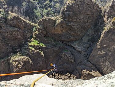
The 55m abseil is from bolts on TL. It is an epic drop and feels very remote. There are only fixed hangers at the anchor point (NO slings, mallions or rings) so it's best to bring some tape or something you are willing to leave behind. The abseil is not 40m as some reports.
After the abseil there is a difficult climb down section into a short swim. Stick to the very right hand walk to climb down an easier chimney, rather than trying to climb down the rocks near the centre. Coming around the sharp right hand corner is another waterfall and a 5m or so drop into another pool. This can be jumped, but there are submerged rocks, so have someone climb down first and find the deep points. This is another good pool to play in, with several good jumps from various heights.
A gully leaves up to the left from this pool and looks very inviting as an exit gully as it heads straight up to the tourist track and an observation deck, however the climb up is too exposed and most of the rocks are just loosely packed in. In its current state it is way too dangerous and has seen people stranded near the top of the gully unable to get out.
Continue following the canyon downstream, around the sharp bend and after 200m of rock hopping and a short swim, the exit "track" heads up the right hand side of the canyon. It is not obvious at all, but follows a small overgrown ledge heading up at a comfortable angle of ascent. There is an aluminium work ladder (how the hell someone got that in there is amazing) right near the bottom which marks the start. The ladder is covered in vines and growth so make sure your party are all looking closely.
Exit[edit]
Climb up the ladder and start the precarious ascent.
The "track" is not that easy to follow and it is all on loose soil on the edge of a very steep cliff, so it is quite treacherous most of the time. The deeper grassy hand-holds are often better than the bomber looking rock holds. The rocks often turn out to friend-hurting missiles when you accidentally dislodge them. Trailing party members beware.
The track takes you to the top of the narrow ridge opposite Tuross Falls, and then to a spectacular viewpoint of the falls. Continue to the top of the ridge where you find yourself at the end of a narrow fire trail. Follow the trail for only a few minutes south-west and exit the track as it turns to head directly south. Start walking directly west from the track and after you drop down into a gully, you will head up over another ridge and then down the other side you will find yourself back at the bottom edge of the first wade pool in the upper section of the creek. Continue back upstream until you reach The Cascades, then back to your car.
If you are not abseiling, either reverse the canyon or exit via the tourist track leading to the viewing platform. To exit via the walking track, walk about 100m back from the falls on the true left of the river (right hand side facing upstream) and around a slight bend there is a rocky section of hill that is easy to climb. Walk up the hill and onto the flat section for about 400m, keeping nearby the cliff and then gully on your right hand side until you intersect the lookout track, a small but well worn trail. Turn left and follow it for about 30 minutes back to the carpark.
The fixed hangers have likely been installed by trad climbers as there are some remote and rarely accessed climbs in the area.
Red tape[edit]
None current. Check the NSW NPWS website prior to going (https://www.nationalparks.nsw.gov.au/visit-a-park/parks/wadbilliga-national-park/local-alerts).
Be aware that there is a possibility that NSW State Forests Corporation could temporarily close the entry road for forestry operations.
Beta sites[edit]
A lot of this report is from the former canyoning.org.au forum, which is now defunct with the URL used by the Australian Canyoning Association. That forum also credits immortaloutdoors.com which does not appear to exist anymore, but is available on WaybackMachine.

