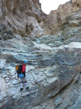
Typhon Canyon (South Fork)
| Rating: | |||||||||||||||||||||||||||||||
|---|---|---|---|---|---|---|---|---|---|---|---|---|---|---|---|---|---|---|---|---|---|---|---|---|---|---|---|---|---|---|---|
| | Difficulty:3A IV (v3a1 IV) Raps:24, max ↨185ft
Red Tape:No permit required Shuttle:Required 60 min Vehicle:Passenger Rock type:Metamorphic and Limestone | ||||||||||||||||||||||||||||||
| Location: | |||||||||||||||||||||||||||||||
| Condition Reports: | 19 Dec 2025
"Weather was surprisingly warm, Id say in the high 50s at the beginning of the day ~6am at Dantes Point.. Approach was fine except the final ridge |
||||||||||||||||||||||||||||||
| Best season: | Oct - Mar
|
||||||||||||||||||||||||||||||
| Regions: | |||||||||||||||||||||||||||||||
Introduction[edit]
Approach[edit]
From Dante's View parking area go along the ridgeline on a well defined trail. After about an hour, descend a saddle down light scree in wide gulley a couple hundred feet before gaining a ridge on left. Head down ridge 1300 ft until some rock protrusion start showing up and enter canyon on left.
(If you are following Bluegnomb beta note that there are no white painted rocks to mark the trail.)
Descent[edit]
Nov. 10, 2019 our GPS data showed 12.1 miles total traveled from car to car (Dante's View to Badwater), 6.5 miles of technical section. 360 elevation gain and 8 1/2 hours moving through canyon, plus another hour of rest/lunch/breaks. This is a bit different than the previous beta.
From Jan 22' Trip
- Bypass a couple drops on right
- R1 - 80 ft down broken runnel off single rock
- Bypass a water carved water course by going right
- Down through an ungulating water course
- R2 - 50' down tight runnel off Boulder constriction
- Walk short ways to short downclimb
- R3- 60' from anchor point, drop is probably 40 ft
- R4 - 25' off small Boulder
- Walk a ways
- R6 - 65' cairn
- R7 - 100' cairn dryfall
- Short 10' slide
- Walk a while
- Semi technical downclimb 20 ft
- Hike for a long ways, canyon opens up in tan rock layer
- R8 - 70' off cairn ending by passing through diagonal arch!
- R9 - 50' off cairn
- R10 - 40' cairn next door from 9
- Walk a bit, down climb left
- Go over major rockfall
- Walk for a while, go through the climbing gym
- Reach an intimidating looking downclimb that can be easily descended down the ramp
- Walk through a slotty cave like section
- R11 - 25' cairn
- R12 - 40' fiddlestick off boulder could easily use webbing
- R13 - 40' off Boulder construction
- R14 - 160' off chockstone 160’ awkward start
- R15 - 185' slung Boulder over three tiered rappel. First into the pothole (30ft), then over the side onto the white rock and then all the way down (30 ft)
- R16 - 30' cairn
- R17 - 100' cairn: 30 + tier (30) + 40 very approximate
- R18 - 25' off knot chock
- R19 - 20' (optional) down slide. (Removed knot chock anchor)
- R20 - 35' boulder constriction
- R21 - 18' slung boulder (probably optional)
- R22 - 25’ off cairn
- R23 - 30' off boulder fiddle sticked
- R24 - 30’ off boulder
- R25 - 40’ rappel down an otherwise steep down climb from small rock chockstone (probably optional)
(There are many downclimbs in the canyon, not all are listed here.)
Exit[edit]
Short walk to road
Red tape[edit]
Beta sites[edit]
 BluuGnome.com : Typhon Canyon - South Fork
 HikeArizona.com : Typhon Canyon
 Super Amazing Map : Typhon Canyon (South Fork)
- Jan 22' Trip
Trip reports and media[edit]
Background[edit]
Discovered and named by Rick Kent. First descent, 22 March 2008: Rick Kent and Mike Cressman.
