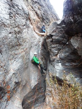
Uranus Canyon
| Rating: | |||||||||||||||||||||||||||||||
|---|---|---|---|---|---|---|---|---|---|---|---|---|---|---|---|---|---|---|---|---|---|---|---|---|---|---|---|---|---|---|---|
| | Difficulty:3A IV (v3a1 IV) Raps:11-19, max ↨105ft
Red Tape:No permit required Shuttle:None Vehicle:Passenger Rock type:Limestone | ||||||||||||||||||||||||||||||
| Start: | |||||||||||||||||||||||||||||||
| Parking: | |||||||||||||||||||||||||||||||
| Condition Reports: | 16 Feb 2025
"A great time with excellent folks! We opted to drive and park rather than start from slabby, and highly recommend it if you don’t have a risk of los |
||||||||||||||||||||||||||||||
| Best season: | Oct-Mar
|
||||||||||||||||||||||||||||||
| Regions: | |||||||||||||||||||||||||||||||
Introduction[edit]
Uranus Canyon has many short rappels. Even the "longer" rappels are really multiple short drops. Described as 11-19 rappels, depending on how whether consecutive rappels are combined (requiring more than 105' listed here as longest rappel) and on the group's comfort with downclimbs.
The whole canyon is in limestone, portions of which have copious amounts of photogenic fossils. The fossils are less numerous than in Gastropod Casket Canyon or Fossil Snail Canyon, but the approach is shorter and the canyon felt more fun than those. We found remains of six bighorn sheep in the canyon.
A cooler option for warm days. The canyon and approach are at 3,000-5,000 feet in elevation. The canyon faces east, so it is shaded in the afternoon.
A bonus for those camping at 'Slabby Acres' is that you can walk from your campsite.
The approach and exit include a 2.4-mile, 750-foot elevation, hike on an alluvial fan. It's not horrendous but it seemed to really drag in both directions.
There were a lot of bees at two small pools of water.
Approach[edit]
Ideal parking is about 1/2 mile west of entrance to 'Slabby Acres' on CA-190. This location sets you up so you can exit by following a drainage. Walking from Slabby would also work.
Walk 2.4 miles north towards an obvious gap. Watch out for cholla.
You will be in a wash in the gap between two mountains. At a major junction in the wash, go left up the wash. When the wash gets to a dry fall, exit by going up the ridge on your right. You might be following portions of a game trail on and off. Your goal is the light-colored saddle on the ridge.
At saddle, follow ridge up. At a very noticeable place, the ridge flattens out. Here you contour to the right to the next ridge. You'll be looking down into Uranus Canyon.
Descend on the far side of that ridge in a shallow gully (about 300'). There will be a few places you do short, easy downclimbs. Helmets recommended due to loose rock.
Descent[edit]
R1 70-foot, 3-stage sloping drop. Anchor from a pinch under a large chock stone. Some stages could be down-climbed. This could be combined with R2.
R2 40-foot, anchored with fiddlestick from a small solid arch at ground level 20 feet back from edge. The rappel goes to a stinky pool with lots of bees, but this could be avoided. There were remains of a dead sheep here. This rappel is at a junction with another fork. We saw webbing on the anchor for the other fork.
Downclimb/slide that some might want meat anchor for.
R4 80-foot, anchored from small stone arch on left wall, two-stage. First a 20-foot slope that is almost climbable, then 12 feet over a chockstone.
Downclimb
R5 35 feet, anchored from pinch point 20 feet back from edge.
Fun 20-foot downclimb
R6 35 feet, from a pinch on chocked rock on the right side 15 feet back from edge. Could be combined with R7.
R7 80 feet two-stage from a rock on left. Big boulders in the middle of rappel, and lots of bees under the boulders.
R8 80 feet from knot chock and small rock chock on left. Could be climbed. Long slope with fossils.
Flat open section of canyon.
R9 (unrecorded length), from cairn anchor. Pretty rappel.
Spicy downclimb.
R10 20 feet, anchored from a pinch. Descend over chockstone. A pinch between two rocks at the top grabbed the previous group's rope tail.
R11 105 feet, including 20 feet back to the rock chock anchor. Last chute could be climbed.
R12 20 feet, anchored from chocked rock. Descend over large chockstone shaped like an iceberg with an alcove under it.
R13 30 feet, anchored by meat anchor then counter weighted with rope through hole in back side of chockstone. Two-stage, ten feet each.
R14 40 feet, anchored from rock on ground level.
R15 (optional?) 90 feet, anchored from two knot chocks on left. Slope, then over a white boulder. Probably could be climbed.
R16 (optional) 20 feet, plus distance to pinch anchor. Or a long bybass on left.
R17 (optional) 15 feet, plus 20 feet to rock we slung rope around. Could be climbed, but were losing light and tired.
Remains of concrete dam, likely constructed to provide water for wildlife. This is your signal you are definitely done with technical canyon.
Exit[edit]
Hike down drainage. It will curve north and you will be frustrated you are going away from your car. Continue until wall on your right gets short and easily climbable. Climb up and had back to your right to a low saddle.
Descend the other side, basically straight back to your car following the wash.
Red tape[edit]
It is illegal to remove anything from Death Valley National Park, including fossils and bighorn sheep skulls.
Also note that 'Slabby Acres' is privately-owned. The owners might decide to evict or prohibit camping at any time.
Beta sites[edit]
Trip reports and media[edit]
First Descent 2-18-17 Trip Report details:
Background[edit]
First Descent 2-18-17 - led by Scott Swaney & team (see above trip report)
