Urumbilum Canyon
| Rating: | |||||||||||||||||||||||||||||||
|---|---|---|---|---|---|---|---|---|---|---|---|---|---|---|---|---|---|---|---|---|---|---|---|---|---|---|---|---|---|---|---|
|
| |||||||||||||||||||||||||||||||
| | Raps:9, max ↨171ft
Red Tape: Shuttle:Optional 30 min Vehicle:Passenger | ||||||||||||||||||||||||||||||
| Location: | |||||||||||||||||||||||||||||||
| Shuttle: | |||||||||||||||||||||||||||||||
| Condition Reports: | 20 Apr 2025
"Orara gauge at 330 ml/day.. Last person can pull down rope on R7 after crossing flow and standing at CR at top of log (3-4 m above pool) to minimi |
||||||||||||||||||||||||||||||
| Best season: | Oct-Apr (avg for this region)
|
||||||||||||||||||||||||||||||
| Regions: | |||||||||||||||||||||||||||||||

Introduction
This is one of the more popular canyons in the area due to its beautiful scenery and challenging abseils. It is quite constricted and can be demanding in high water.
Water levels
River Gauge ML/day: Orara @ Orange Grove 204068 - WaterNSW WaterInsights
- <150 (174 m3/s) = a3, easy
- 150 to 300 (3.47 m3/s) = a4
- >300 = a4+, solid!
Note: The catchment for Orara @ Orange Grove 204068 river gauge is approximately 126 square kilometres according to Water NSW. The catchment above and along Urumbilum Canyon is approximately 5 square kilometres. As a result it is possible for Orara @ Orange Grove river gauge to not accurately represent the conditions in Urumbilum. The Orara @ Orange Grove river gauge is located at -30.25779, 153.01140, approximately 16km downstream (following river, not "as the crow flys") of the start of Urumbilum Canyon start.
Approach
Long car shuffle: from the intersection of Range Road and Pine Road, turn onto Pine Road and follow this all the way to the bottom. Pine Road has huge water bars and requires high clearance vehicles. Note that two other roads shown on the NSW topo in the National Park, Jersey Bull Road and Wayper Creek Road are impassable from the top. Bottom car can be parked where Pine Road intersects with Jersey Bull Road - there is a nice grassy patch and a sign. Or you can now drive 1.2km up Jersey Bull Road from here to the Bindarray picnic area to save a 1.2km road walk (requires 1 creek crossing).
Then drive back up Pine Road, onto Range Road and down Urumbilum Creek Road to the ford, and the start of the canyon. This is where the top car goes.
Shorter 4wd shuffle: drive about 1km along the powerline track, ie. left from Range Road about 400m before the turnoff to Bangalore Road. Leave a car at the gate at the intersection with Jersey Bull road. The powerline track was clear in October 2025. It is also possible to reach the gate by driving along Jersey Bull road from Pine road. This track was clear in April 2026.
Descent
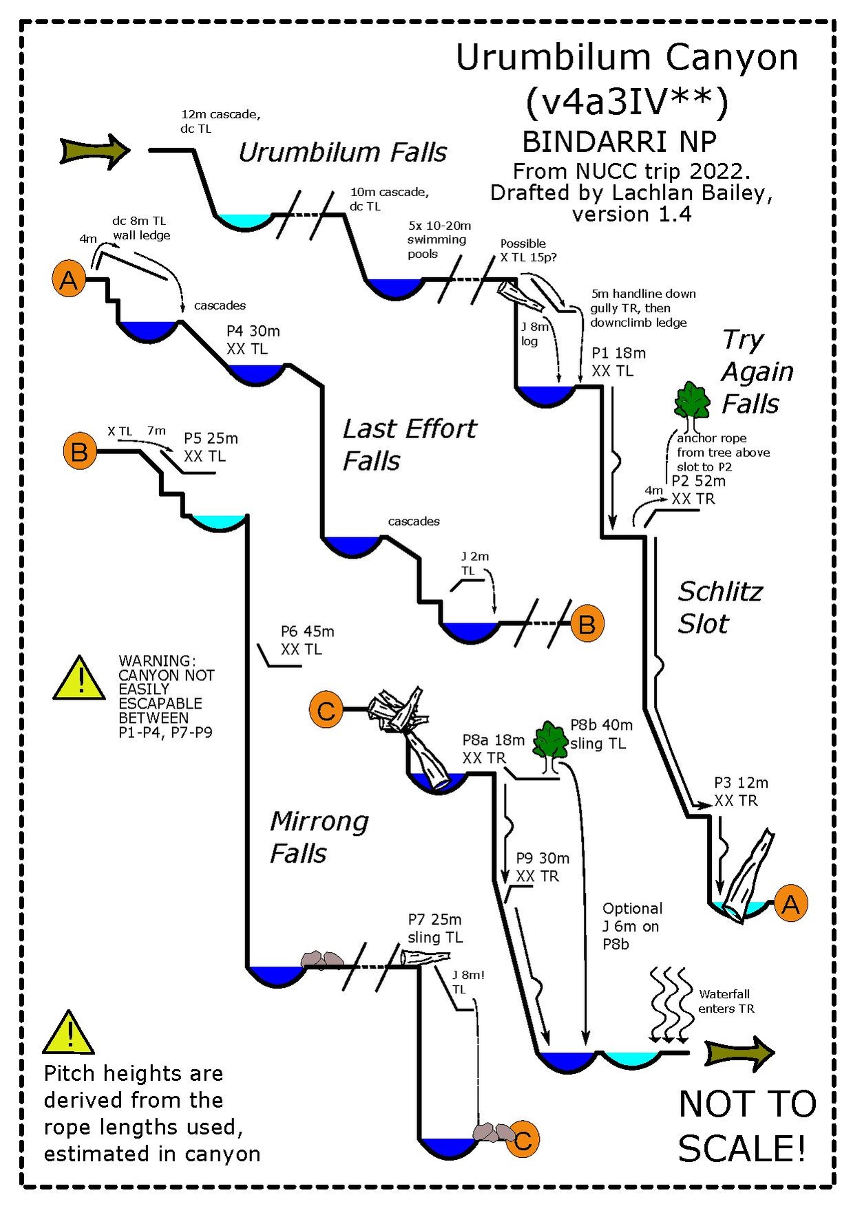
Get changed into wetsuits at top car
| Rap | M | L/R | Description |
|---|---|---|---|
| Easy, flat creek walking until the drops begin | |||
| 12 | CL | Down climb followed by some more creek walking | |
| R0 | 20 | CL | XX (bolts). Or 5m handline CR then scramble down more on CR and do 5m jump into pool |
| R1 | 18 | CL. | Abseil down through flow onto rocks. |
| R2 | 52 | CR | Schlitz slot. Abseil down slot through flow. Beware of foot entrapments in centreline of slot. Watch for spillover in pool at the bottom - there is a shallow ledge in pool on CL. |
| R3 | 10 | CR | Log / strainer in pool. |
| CL | Immediately after R3, use ledges on CL to down climb into pool. | ||
| R4 | 25 | CL | Anchor is a bit back from the edge - bolts are on rock across pool from where waterfall begins. Pool at the bottom of drop is very deep - can do >10m jump from ledge on CL of waterfall, or 3m jump from ledge CR - abseil down to ledges. |
| Creek walking section which includes multiple small jumps and a few downclimbs | |||
| R5 | 18 | CL | Anchor is high up near a small tree. If you’re at the small pool just before the waterfall drops off then you’ve gone too far down - look up. |
| R6 | 40 | CL. | XX Accessed using R5 - bolts are part way down waterfall on rock on CL. |
| Another creek walking section with more small jumps and down climbs, possible exits CR for a shorter day, but it's a shame to miss R7, R8, R9. | |||
| R7 | 25 | CL | Log sling. Very large logs at bottom that obstruct route. Abseil through flow from CL to CR crossing the flow. Be very careful not to get your rope stuck. Topo says there is an option for a technical jump towards the bottom - this no longer exists due to massive logs. With the presence of the large logs across the route it’s recommended a future party split this drop in two by adding some bolts half way down … maybe on CR. |
| Immediately after R7 there is an impressive log jam, down climb into big pool after which there is R8. | |||
| R8/9, two options: R8a 10m and R9 30m; or R8b 45m | |||
| R8a | 10 | CR | XX only room for one person in alcove |
| R9 | 30 | CR | XX Slot waterfall in R9 is spicy - be comfortable abseiling in high flow, and likely pulldown while swimming. |
| R8b | 45 | CL | Sling around tree. Dry abseil into deep |
| If exiting down creek there are two optional rappels to avoid small hazards at the confluence Bangalore creek RL | |||
| 5m | CL | Under boulder | |
| 5m | CR | Side of rock into pool |
Exit
Walk-out with long car shuffle: Creek walk along Urumbilum River. Almost immediately after the intersection intersection of Bangalore and Urumbilum rivers is some small drops:
- 3m drop CL single bolt - on slight overhanging large boulder
- 8m drop CR single bolt - up high… will need to scramble up
Then creek walk all the way down the river - watch out for snakes. You will eventually get to a picnic area (marked as a ford on the map) and then can follow Jersey Bull Road back to the bottom car.
Climb-out with short car shuffle: scramble up the steep ridge across from the junction of Bangalore into Urumbilum, to reach Jersey Bull road. Some bushbashing, some logging tracks. Mostly clear but steep. Walk up the road to a top car at the gate on the powerline track.
One-car long trip returning to top: After exiting the large, deep pool of the final abseil P9, the creekwalk turns sharply left before continuing straight for 100m. Exit on the ridgeline CL at a grove of palm trees, shortly before the creek makes a second left-hand turn. Walk directly uphill until meeting a snig track on top of the ridge. Follow this to the top of the hill (marked "475m" on the map), occasionally exiting the snig track to avoid dead trees or debris. From the top of the hill, follow the overgrown Bangalore Rd Firetrail for approximately 1.6km. Shortly after passing a massive tree blocking the path, the road takes a sharp right turn. Walk left up the embankment, skirting to the left side of a large smooth slab visible from the road. Follow the saddle uphill - several snig trails make passage easier. Locate the small, unmarked rocky creek flowing down the gully on the other side of the saddle, and follow this to where it crosses Urumbilum Creek Rd. Ensure you choose the correct direction - left or right - on Urumbilum Creek Rd to locate your parked car.
One-car short trip returning to top: A few hundred metres below Mirrong falls P6, choose a suitable ridge or similar on CR, scramble/slog steeply up to the disused part of Urumbilum road. Walk back to the car at Urumbilum creek.
Red tape
Beta sites
Trip reports and media
 YouTube.com : Craving Karst, Urumbilum Canyon, December 2022